

Adina Sommer
Antique and Contemporary Art
Winzerer Str. 154
80797 München
telephone
+49 89 304714
business hours:
by appointment
Email
![]()


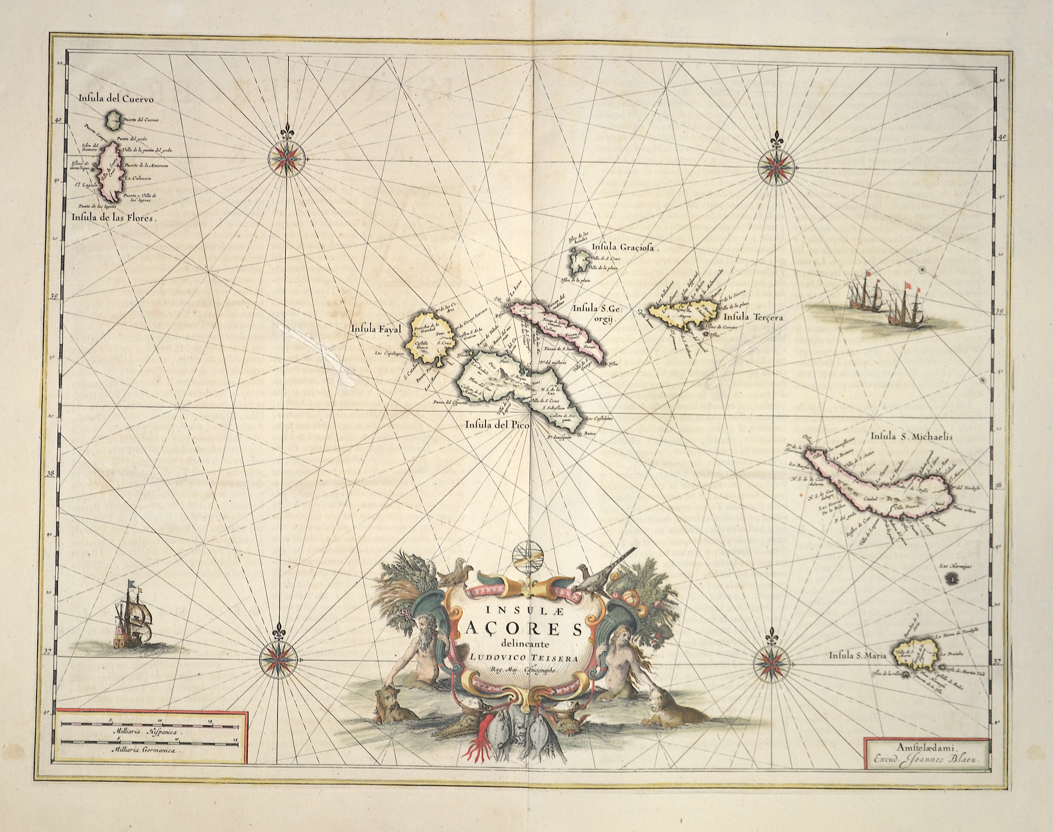
Insulae Acores delineante Ludovico teisera

| Article ID | EUE1195 |
Title | Insulae Acores delineante Ludovico teisera |
Description | Map shows the Azores Islands. |
| Year | c. 1660 |
Artist | Blaeu (1571-1638) |
Joan Guilliemus Blaeu was the eldest son of Willem Janszoon Blaeu (1571-1638), and was probably born in Alkmaar in the province of Noord-Holland in the final years of the 16th century. He was brought up in Amsterdam, and studied law at the University of Leiden before going into partnership with his father in the 1630s. Although his father Willem had cartographic interests, having studied under the Danish astronomer Tycho Brahe and having manufactured globes and instruments, his primary business was as a printer. It was under the control of Joan that the Blaeu printing press achieved lasting fame by moving towards the printing of maps and expanding to become the largest printing press in Europe in the 17th century. By the 1660s the Theatrum Orbis Terrarum (or Atlas Maior as it had became known by this time) had expanded to between 9 and 12 volumes, depending on the language. With over 3,000 text pages and approximately 600 maps, it was the most expensive book money could buy in the later 17th century. The translation of the text from Latin into Dutch, English, German, French, and Spanish for several volumes created enormous work for those involved in typography and letterpress activities. It is estimated that over 80 men must have been employed full-time in the Blaeu printing house in Bloemgracht, not including engravers who worked elsewhere, with over 15 printing presses running simultaneously, and in 1667 a second press was acquired at Gravenstraat. At the same time as producing the Atlas Maior, Blaeu was also publishing town plans of Italy, maps for globes, and other volumes. At its peak the Blaeu press managed to produce over 1 million impressions from 1,000 copper plates within four years. | |
Historical Description | The islands are first recorded on the Portolan nautical charts of the 14th century, such as the Medici Atlas (1351) and the Atlas Catalan (1375). The Azores were officially visited and taken possession of for Portugal in 1427 by Diogo de Silves on behalf of Henry the Navigator. The Portuguese name Ilhas dos Açores ("Hawk Islands") originated, according to the official Azorean account, because of the numerous buzzards living there, which the Portuguese conquerors initially mistook for hawks. The name remained even after the error was discovered. Portuguese settlement began in the mid-15th century, first on Santa Maria Island from 1431. The Azores soon became an important base on the way to the possessions in Central and South America. Thus, Christopher Columbus visited the islands in 1493 on his way back from his first voyage of discovery. |
| Dimensions (cm) | 38 x 49 |
| Condition | Wormholes perfectly restored |
| Coloring | original colored |
| Technique | Copper print |