

Adina Sommer
Antique and Contemporary Art
Winzerer Str. 154
80797 München
telephone
+49 89 304714
business hours:
by appointment
Email
![]()


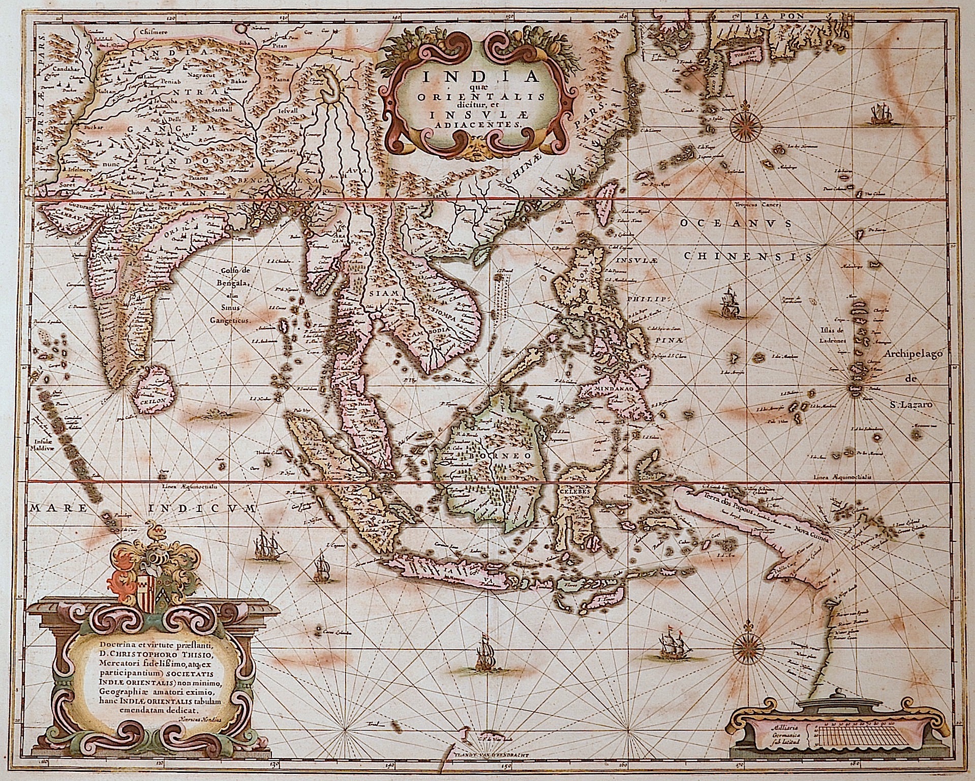
India quae Orientalis dicitur, et Insulae adiacentes.

| Article ID | ASS0982 |
Title | India quae Orientalis dicitur, et Insulae adiacentes. |
Description | Map shows total Souteast Asia with India, Indonesia and three decorative artouches with coat of arms. |
| Year | ca. 1636 |
Artist | Hondius (1597-1650) |
Jodocus Hondius (1563 –1612) was a Dutch engraver, and cartographer. He is best known for his early maps of the New World and Europe, for re-establishing the reputation of the work of Gerard Mercator, and for his portraits of Francis Drake. He helped establish Amsterdam as the center of cartography in Europe in the 17th century. He was born in Wakken and grew up in Ghent. In his early years he established himself as an engraver, instrument maker and globe maker. In 1584 he moved to London to escape religious difficulties in Flanders. While in England, Hondius was instrumental in publicizing the work of Francis Drake, who had made a circumnavigation of the world in the late 1570s. In particular, in 1589 Hondius produced a now famous map of the bay of New Albion, where Drake briefly established a settlement on the west coast of North America. Hondius' map was based on journal and eyewitness accounts of the trip and has long fueled speculation about the precise location of Drake's landing, which has not yet been firmly established by historians. Hondius is also thought to be the artist of several well-known portraits of Drake that are now in the National Portrait Gallery in London. In 1593 he moved to Amsterdam, where he remained until the end of his life. In co-operation with the Amsterdam publisher Cornelis Claesz. in 1604 he purchased the plates of Gerard Mercator's Atlas from Mercator's grandson. Mercator's work had languished in comparison to the rival Theatrum Orbis Terrarum by Ortelius. Hondius republished Mercator's work with 36 additional maps, including several which he himself had produced. Despite the addition of his own contributions, Hondius gave Mercator full credit as the author of the work, listing himself as the publisher. Hondius' new edition of Mercator's work was a great success, selling out after a year. Hondius later published a second edition, as well as a pocket version Atlas Minor. The maps have since become known as the ""Mercator/Hondius series"" . In the French edition of the Atlas Minor we find one of the first instances of a thematic map using map symbols. This is a map entitled Designatio orbis christiani (1607) showing the dispersion of major religions. Between 1605 and 1610 he was employed by John Speed to engrave the plates for Speed's The Theatre of the Empire of Great Britaine. Hondius died, aged 48, in Amsterdam. After his death, his publishing work in Amsterdam was continued by his widow, two sons, Jodocus II and Henricus, and son-in-law Johannes Janssonius, whose name appears on the Atlas as co-publisher after 1633. Eventually, starting with the first 1606 edition in Latin, about 50 editions of the Atlas were released in the main European languages. In the Islamic world, the atlas was partially translated by the Turkish scholar Katip Çelebi. The series is sometimes called the ""Mercator/Hondius/Janssonius"" series because of Janssonius's later contributions. | |
Historical Description | In the first centuries after the turn of the times, Indian traders spread their culture over large parts of Southeast Asia. The Kingdom of Funan (200-550) in the Mekong Delta developed into the first center of Hinduism and Buddhism in Southeast Asia. It was replaced by the Khmer Kingdom and the Srivijaya Empire in Sumatra. 750 Borobodur was built on Java, a terraced temple complex of enormous size. The Khmer kings created an equally impressive work of art with the construction of their Angkor Wat temple complex. From the 9th century, the Tai migrated from the north to their present-day settlement areas and met the high-ranking Mon, whose culture they shaped. In 1044 the first Burmese Empire was founded with Bagan as the capital. In Southeast Asia, extensive trade had developed from the 6th to the 16th century, numerous shipwrecks testify to this development, such as that of the Lena Shoal junk. The ship types of the junk and the balangay were used for this trade. Two main routes of trade China on the one hand and Java, Sumatra and the Malay Peninsula on the other hand could be determined. One route leads along the mainland and the second route along Borneo, Palawan to the island of Luzon. In the 15th century, Arab, Persian and Indian traders converted the Malays to Islam. The Muslim Malacca took the place of the Hindu kingdom Majapahit on Java. With the exception of Siam, all Southeast Asian countries were colonized from the 16th century. The background to colonization was the region's wealth of raw materials and spices, which were of particular value at the time. After the trade had been dominated by Arab traders for a long time, the European powers now fought over supremacy in the region. The Spaniards became active in the region at the same time and colonized with the aim of conquering China and converting to Christianity the Philippines, which they named after the Spanish King Philip II. The British came to Southeast Asia as the third major colonial power and also tried to establish themselves in the region. After initially holding an insignificant base in Indonesia, after negotiating with the local sultans, they reached control of the island of Penang and Singapore, which was then a small Malay fishing village. Together with the port city of Malacca, these areas formed the so-called Straits Settlements, the most important bases for the British in Southeast Asia. |
| Place of Publication | Amsterdam |
| Dimensions (cm) | 39,5 x 49 |
| Condition | Some restorations along the orig. outline colours |
| Coloring | original colored |
| Technique | Copper print |