

Adina Sommer
Antique and Contemporary Art
Winzerer Str. 154
80797 München
telephone
+49 89 304714
business hours:
by appointment
Email
![]()


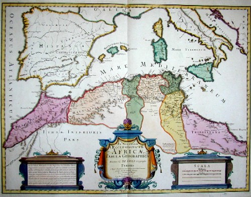
In Notitiam Ecclesiasticam Africae Tabula Geographica

| Article ID | AF0103 |
Title | In Notitiam Ecclesiasticam Africae Tabula Geographica |
Description | Map shows Marocco, Algeria and Tunesia with Spain, Balear Islands, Corsica, Sardinia and Sicily. |
| Year | dated 1700 |
Artist | L´Isle, de /Covens & Mortier (1675-1726) |
Guillaume De L’Isle (1675–1726) was a renowned French cartographer famous for his accurate maps of Europe, the Americas, and Africa. He joined the French Académie Royale des Sciences, signing his maps as “Géographe de l’Académie,” and later became Premier Géographe du Roi in 1718, teaching geography to the Dauphin. De L’Isle mostly worked from his office, relying on a strong network of traveler reports and scientific updates, ensuring his maps were precise and honest. He openly noted uncertain information, such as a disputed river in Louisiana. In 1700, he won a legal case against Jean-Baptiste Nolin for plagiarism. Unlike the Sanson workshop, which often published outdated maps, De L’Isle focused on up-to-date, scientifically grounded cartography. | |
Historical Description | North Africa in the broader geographical sense is the area of the continent of Africa that includes the Sahara and the coastal strip to the north, west and east of the Mediterranean, the Atlantic and the Red Sea. Religiously, North Africa is mainly characterized by Islam, ethnically by Berbers, Moors and Arabs, in the southernmost area also Nubians, Amhars and Black Africans. The core states of North Africa include Morocco with the Western Sahara, Algeria, Tunisia (small Maghreb), Libya (Greater Maghreb), Egypt and Sudan. Especially during the ongoing desert phase, contacts between North and sub-Saharan Africa were therefore limited almost exclusively to trade along the east and west coasts of the continent and to certain routes where there were sufficient water points, due to the difficulties of crossing the world's largest sandy desert. At the same time, this meant ethnic separation, and although North African culture has both African and Middle Eastern roots, with the Berbers possibly even European. With antiquity in the narrower sense, the interests of the Mediterranean peoples, which had previously been focused primarily on Egypt and the Near East in terms of power politics, gradually changed. As so often in history, it was trade that paved new paths; and the first people to devote themselves entirely to Mediterranean trade, even to the neglect of their own state structures, were the Phoenicians, but the place in North Africa where territorial state structures did develop, at least to some extent, was Carthage. In the period between the destruction of Carthage and Rome taking control of the Maghreb, there was a brief flourishing of local kingdoms. Two largely sedentary ethnic groups, the Moors and Numidians, were of particular importance. After the victory over Carthage, Roman culture and, above all, Roman administration spread relatively quickly from east to west along the Atlas mountain ranges across the new territories in North Africa. The North African provinces quickly became economically central to the Roman Empire, and between the 1st and 4th centuries AD, Rome's survival actually depended on grain and olive supplies from there, as the climate in North Africa at that time was wetter than it is today. When the Romans took power in the Mediterranean, a development came to an end in the course of which North Africa in particular finally became part of the Mediterranean world. |
| Place of Publication | Paris |
| Dimensions (cm) | 48 x 64 cm |
| Condition | Very good |
| Coloring | original colored |
| Technique | Copper print |