

Adina Sommer
Antique and Contemporary Art
Winzerer Str. 154
80797 München
telephone
+49 89 304714
business hours:
by appointment
Email
![]()


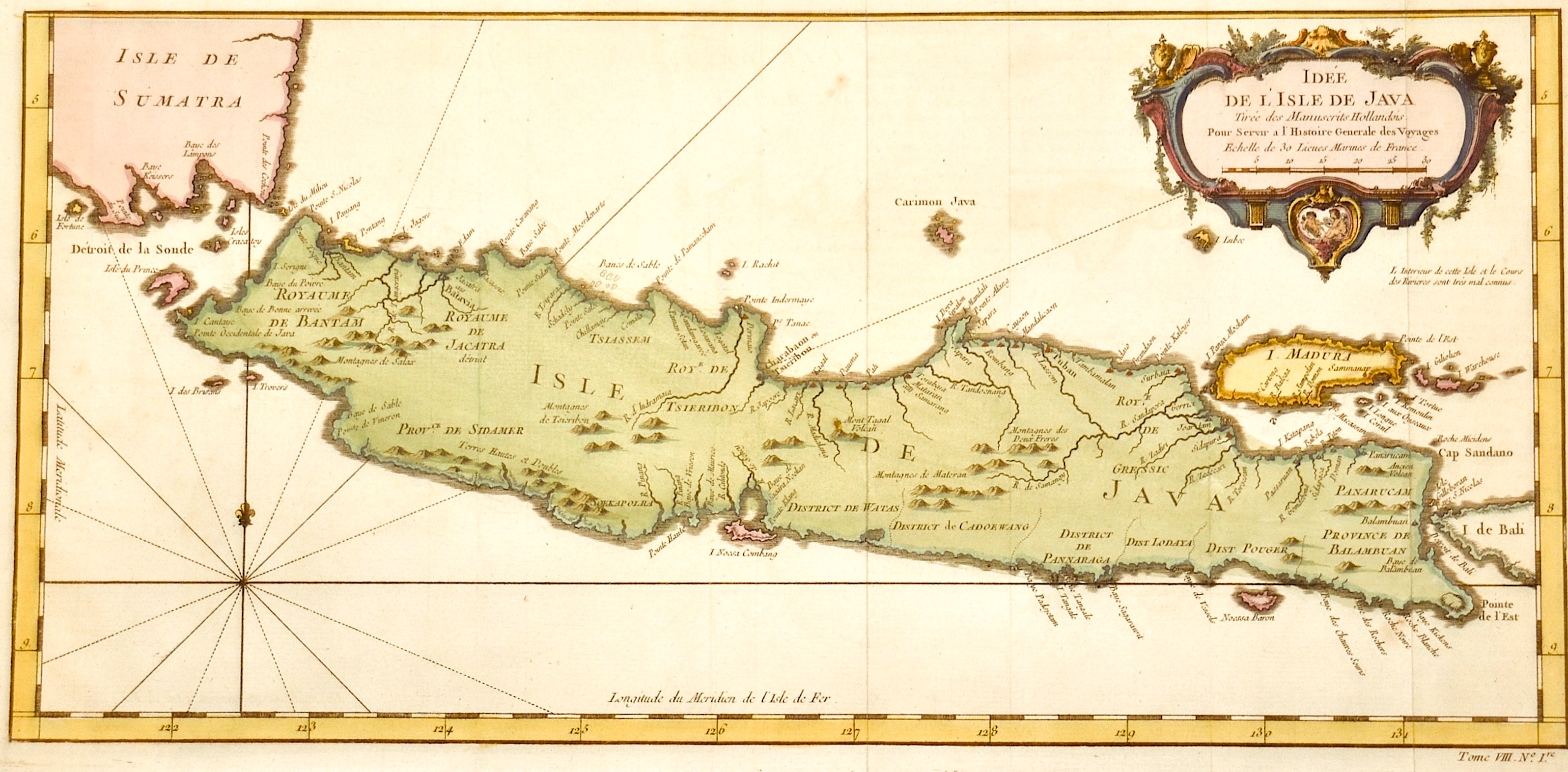
Idee de l´Isle de Java

| Article ID | ASS0371 |
Title | Idee de l´Isle de Java |
Description | Map shows the island of Java. |
| Year | ca. 1720 |
Artist | Fer, de (1646-1720) |
Nicolas de Fer ( 1646 - 1720 in Paris) was a French cartographer and geographer. He also was an engraver and publisher. De Fer was the youngest of three sons of Antoine de Fer, who was also a cartographer. When he was 12, he became the apprentice of Parisian engraver Louis Spirinx, and made his first map, of the Canal du Midi, at the age of 23. After the death of his father in June 1673, de Fer was so successful at improving the firm that, in 1690, he became the official geographer to Louis, Dauphin of France. With support from the Spanish and French Royal Families, de Fer also became official geographer for Philip V and Louis XIV, the kings of Spain and France, respectively. Because of this, his maps became Bourbon propaganda, endorsing French King Louis XIV. His business flourished, producing town plans, atlases, wall maps, and more than 600 sheet maps.He made maps of places in Europe and North America, including New Spain, places fortified by Vauban, the Low Countries, and the War of the Spanish Succession. In 1698, de Fer published a map of North America, which included a depiction of beavers building dams near Niagara Falls. Seventeen years later, Herman Moll published an identical map as his own, known as the -Beaver map-. De Fer became the official geographer for His Catholic Majesty in 1720.Two of his sons-in-law, Guillaume Danet and Jaques-François Bénard, continued the company after de Fer's death on 25 October of that year until around 1760. | |
Historical Description | The island's exceptional fertility and rainfall allowed the development of wet-field rice cultivation, which required sophisticated levels of cooperation between villages. Out of these village alliances, small kingdoms developed. The chain of volcanic mountains and associated highlands running the length of Java kept its interior regions and peoples separate and relatively isolated. Java's contact with the European colonial powers began in 1522 with a treaty between the Sunda kingdom and the Portuguese in Malacca. After its failure, the Portuguese presence was confined to Malacca, and to the eastern islands. In 1596, a four-ship expedition led by Cornelis de Houtman was the first Dutch contact with Indonesia. In June 1619 the Dutch moved to Jakarta, which influenced them under the name Batavia to the center of the colonial empire in Asia. Realization of colonial rule also spread to Java. He was particularly significant because he was heard by many as a counterweight to the culture of European perception. On the other hand, the Dutch hardly attempted Christian missionary work. The Dutch use Chinese as traders and tax collectors, they concern each other incredibly in the social relationship. At the beginning of the 19th century, the Eligible State owned control of the colony. Since the administration was proclaimed, Java has been the center of the Republic of Indonesia with the state capital Jakarta. |
| Place of Publication | Paris |
| Dimensions (cm) | 20,5 x 43 |
| Condition | Very good |
| Coloring | colored |
| Technique | Copper print |