

Adina Sommer
Antique and Contemporary Art
Winzerer Str. 154
80797 München
telephone
+49 89 304714
business hours:
by appointment
Email
![]()


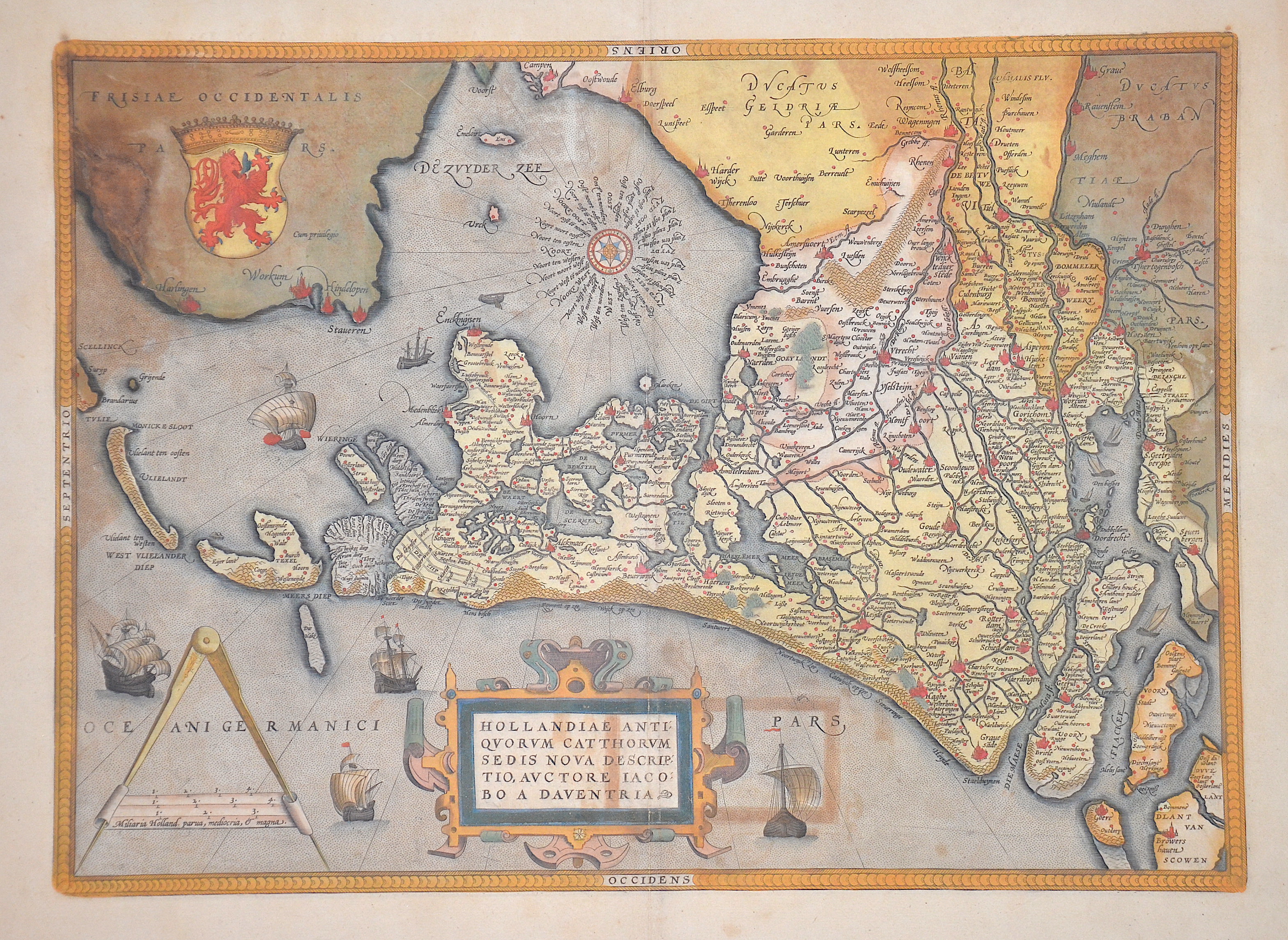
Hollandiae antiquorum cattorum sedis nova descriptio, auctore Jacobo A Daventria

| Article ID | EUN592 |
Title | Hollandiae antiquorum cattorum sedis nova descriptio, auctore Jacobo A Daventria |
Description | Map shows the whole of Holland with, wind rose, 5 sailing ship charts, a title and mileage indicator cartouche. At the top left is the former coat of arms of the county of Holland. |
| Year | ca. 1570 -1612 |
Artist | Ortelius (1527-1598) |
Abraham Ortelius (1527–1598) was a Flemish cartographer and publisher from Antwerp. Originally a map colorist, he became a major figure in cartography through his Theatrum Orbis Terrarum (1570), considered the first modern atlas—a uniform collection of reliable maps in book form. Influenced by Gerardus Mercator, Ortelius published several maps before compiling the Theatrum, which clearly showed America as a separate continent. The work was published in 42 editions and 7 languages by 1612. Unlike many of his peers, Ortelius cited his sources, and his atlas became a milestone in mapmaking and geographic knowledge. | |
Historical Description | After the division of the Franconian Empire, the lower lands belonged to the East Franconian Kingdom (Regnum Teutonicum) and then to the Holy Roman Empire. Under Emperor Charles V, who was also King of Spain, the country was divided into seventeen provinces and also included what is now Belgium and parts of northern France and western Germany. The rift between Catholics loyal to Spain and radical Calvinists was torn too deep and led to the Calvinist provinces of Holland, Zeeland and Utrecht joining together in a defensive alliance in 1579, the Union of Utrecht. This treaty became the charter of a new state, the Republic of the United Netherlands. Only after an eighty-year war was the independence of the Netherlands from Spain recognized in the Peace of Westphalia in May 1648. This date is considered the birthday of today's Netherlands. As a result, as the republic of the Seven United Provinces, the Netherlands grew to become the greatest trading and economic power of the 17th century. This era is known as the Golden Age. However, this did not come from the state, but from the first two public companies in history, the Dutch East India Company (VOC) and the Dutch West India Company (WIC). The founding of New Amsterdam is well known (Nieuw Amsterdam), which was later renamed New York. In Asia, the Dutch created their colonial empire, the Dutch East Indies, what is now Indonesia. The Netherlands also gained colonies in northeastern South America. In Europe, the Netherlands was a great power in the 17th century, led by bourgeois politicians like Johan van Oldenbarnevelt and Johan de Witt. |
| Place of Publication | Antwerp |
| Dimensions (cm) | 35 x 49 cm |
| Condition | Mounted, some restorations at the old colored parts |
| Coloring | original colored |
| Technique | Copper print |