

Adina Sommer
Antique and Contemporary Art
Winzerer Str. 154
80797 München
telephone
+49 89 304714
business hours:
by appointment
Email
![]()


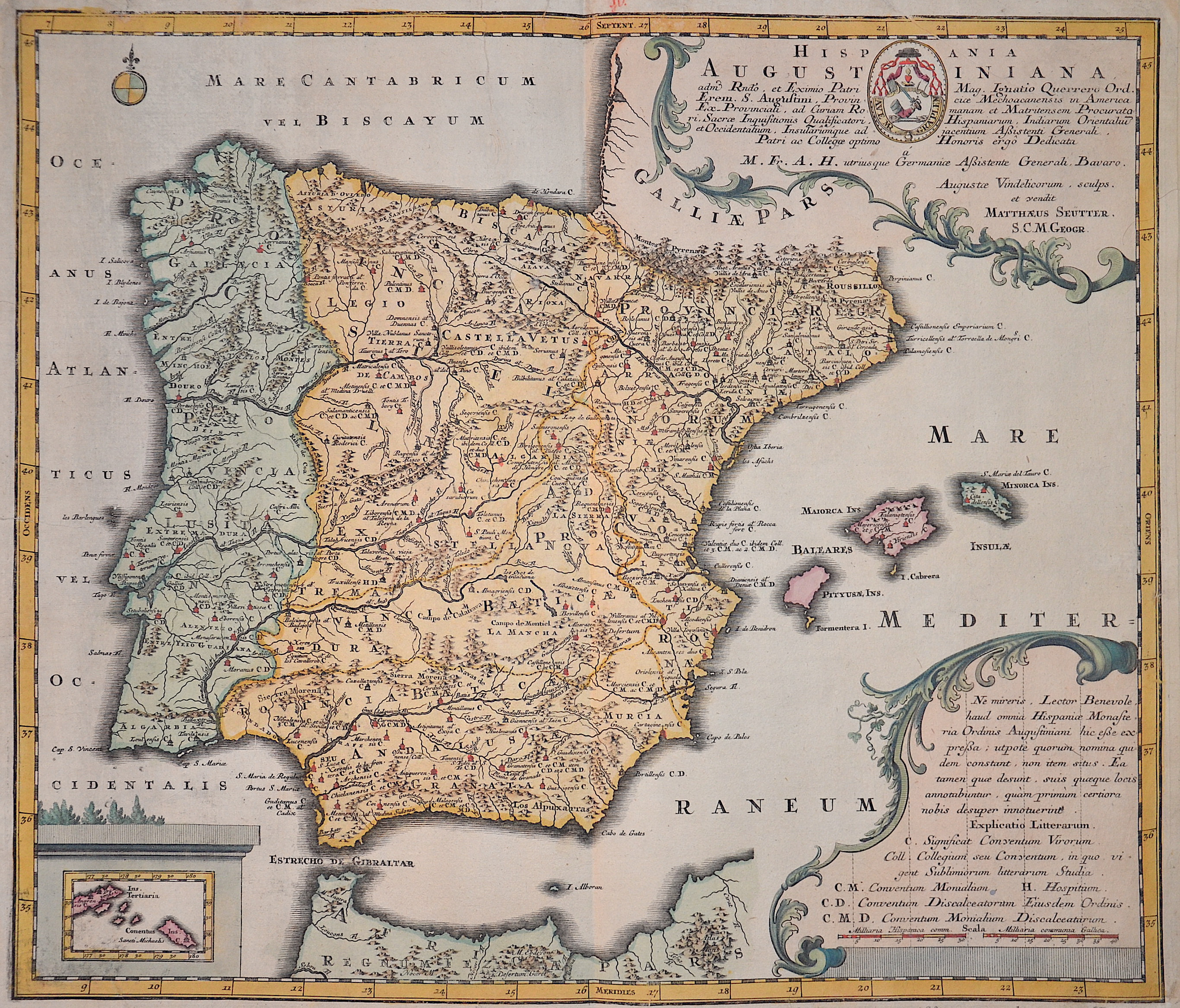
Hispania Augustiniana

| Article ID | EUE3802 |
Title | Hispania Augustiniana |
Description | Decorative mao of Spain with Portugal, the Baleares and partly the islands of Teneriffa and the island Conentus. |
| Year | ca. 1725 |
Artist | Seutter |
Matthias Seutter (1678- 1757) Augsburg was the son of a goldsmith in Augsburg. In 1697, Seutter began his studies in Nuremberg and subsequently worked in the publishing house of Jeremias Wolff in Augsburg. In 1710, he established his own publishing house and print shop. The Seutter publishing house produced a great number of maps, atlases, and globes. However, very few original maps were printed there, as Augsburg at that time had no university and no connection to the fields of mathematics or the natural sciences. Seutter therefore copied the work of other cartographers, making his own engravings based on their models. Over 500 maps were produced in his studio. Seutter's most well-known works are the 1725 "Geographical Atlas or an Accurate Depiction of the Whole World" ("Atlas Geographicus oder Accurate Vorstellung der ganzen Welt") with 46 maps, the 1734 "Large Atlas" ("Grosser Atlas") with 131 maps, and the 1744 pocket atlas "Small Atlas" ("Atlas minor") with 64 maps. Matthäus Seutter died in 1757. Seutter's son Albrecht Karl, his son-in-law Conrad Tobias Lotter, and his business partner Johann Michael Probst ran the printing business for five more years. | |
Historical Description | In prehistoric and prehistoric times, Iberians, Celts and Basques settled on the Iberian peninsula named after the former. In the 11th century BC The Phoenicians settled on the south coast; the most famous of their colonies was Cadiz. The name Spain is derived from the Roman name Hispania (from Phoenician ishapan "land of the rock hyrax". In the early 8th century, the Moors destroyed the Visigoth Empire and conquered the entire Iberian Peninsula. Their centuries of rule shaped the country. The Arabic heritage was reflected in both the architecture and the language. However, the Moors were unable to establish themselves permanently in the northern outskirts of the peninsula. From there the "Reconquest" (Reconquista) started. In this process, which spanned several centuries (722–1492) and was not continuous, the Muslim empires were gradually pushed back by the Christian empires until the fall of Granada in 1492, the last Moorish state structure on the peninsula also disappeared. In the 15th century, the kingdoms of Castile and Aragon were united. Aragon was an important maritime power in the Mediterranean at that time. The Spanish colonial empire extended around 1600 across large parts of South and Central America, the southern part of today's USA and the Philippines. As the English and French also intensified their colonial efforts, Spain gradually lost its supremacy. The liberation wars of the American states, particularly the Mexican and South American wars of independence in the early 19th century, brought independence to most of the colonies. In 1898, the last major properties were lost to the United States during the Spanish-American War, which meant the end of the colonial empire. The African colonies that followed later (Spanish-Morocco, Spanish-Sahara and Equatorial Guinea) finally became independent in the 20th century. |
| Place of Publication | Augsburg |
| Dimensions (cm) | 49,5 x 57,5 |
| Condition | Tears on upper and lower margin perfectly restored |
| Coloring | original colored |
| Technique | Copper print |