

Adina Sommer
Antique and Contemporary Art
Winzerer Str. 154
80797 München
telephone
+49 89 304714
business hours:
by appointment
Email
![]()


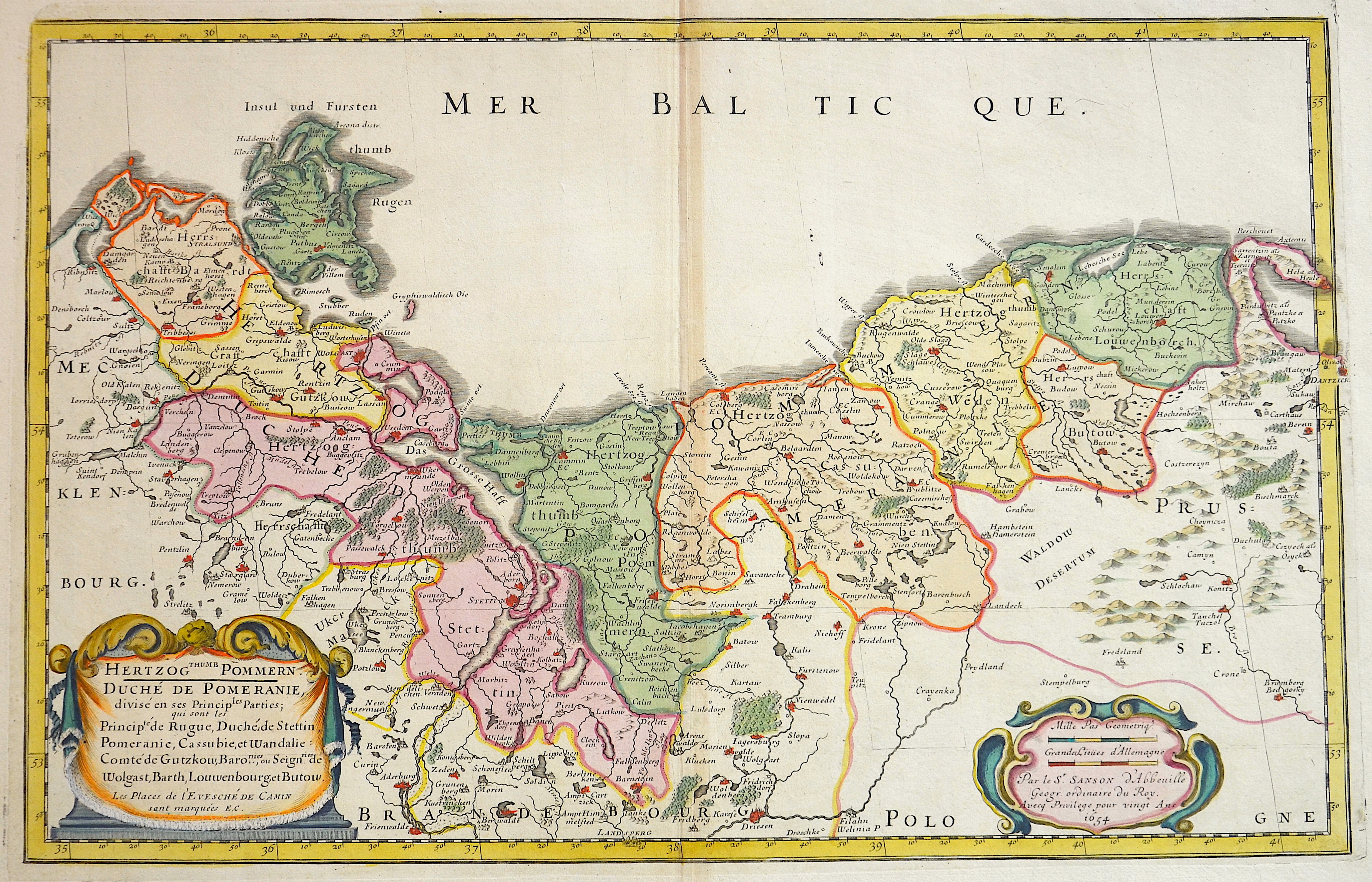
Herzogthumb Pommern

| Article ID | EUD1883 |
Title | Herzogthumb Pommern |
Description | Map shows total Pommern with the island of Ruegen |
| Year | dated 1654 |
Artist | Sanson (1600-1667) |
Nicolas Sanson (1600–1667) was a French cartographer, termed by some the creator of French geography, in which he's been called the father of French cartography. Active from 1627, Sanson issued his first map of importance, the ""Postes de France"", which was published by Melchior Tavernier in 1632. After publishing several general atlases himself he became the associate of Pierre Mariette, a publisher of prints. In 1647 Sanson accused the Jesuit Philippe Labbe of plagiarizing him in his Pharus Galliae Antiquae; in 1648 he lost his eldest son Nicolas, killed during the Fronde. Among the friends of his later years was the great Condé. He died in Paris on 7 July 1667. Two younger sons, Adrien (d. 1708) and Guillaume (d. 1703), succeeded him as geographers to the king. In 1692 Hubert Jaillot collected Sanson's maps in an Atlas nouveau. See also the 18th century editions of some of Sanson's works on Delamarche under the titles of Atlas de géographie ancienne and Atlas britannique; and the Catalogue des cartes et livres de géographie de Sanson (1702). | |
Historical Description | The name Pomerania is the Germanized form of a Slavic landscape name, which is derived from a Slavic phrase meaning "by the sea". Before the Great Migration, the later Pomerania was settled by the East Germanic tribes of the Rugians (since the 6th century BC) in the west and the Goths (since around 100 BC) in the east. When large parts of them sought new places in the south in the course of the migration of peoples, Slavic tribes settled there from the end of the 5th century. In the 12th and 13th centuries, the Pomeranian imperial fiefdom experienced a demographic as well as an economic and cultural turning point in the course of its integration into the ecclesiastical and secular structures of the empire and the massive settlement of Germans and Flemings in the course of the eastern settlement. It became part of the Low German-speaking area. This development was promoted by the dukes from the Slavic house of griffins, who wanted to increase the number of inhabitants and the tax power of their fiefs. Numerous monasteries, towns and villages were newly founded or expanded, thus creating the current settlement structure. From 1534 the Reformation found its way into Pomerania. By confiscating the extensive ecclesiastical lands, the dukes expanded their position of power. With the Peace of Westphalia in 1648, Western Pomerania became part of Brandenburg, and Western Pomerania became Swedish Pomerania. The country was divided and economically poor. During the Swedish-Polish War (1655–1660) and also in the Swedish-Brandenburg War (1674–1679), the area was occupied by Swedish troops, and the larger cities of Stettin, Stralsund and Greifswald, which had been developed into fortresses, were besieged. The Brandenburg Elector Friedrich Wilhelm I succeeded in conquering all of Swedish Pomerania in 1678. Although the estates had already paid homage to him, under pressure from France in the Peace of Saint-Germain he had to give up the conquered areas with the exception of the narrow strip of land east of the Oder. Brandenburg and later the Kingdom of Prussia never waived their claims to the whole of Pomerania. After the end of the Great Northern War (1700–1721), West Pomerania came south of the Peene with the islands of Usedom and Wollin to the Kingdom of Prussia, which had administered this area since 1713 under Sequester. Borders were shifted several times, but with the accession of the GDR to the area of application of the Basic Law of the Federal Republic of Germany, the state of Mecklenburg-Western Pomerania was reconstituted in October 1990, albeit with a different regional structure. |
| Place of Publication | Paris |
| Dimensions (cm) | 32,5 x 50,5 |
| Condition | Very good |
| Coloring | original colored |
| Technique | Copper print |