

Adina Sommer
Antique and Contemporary Art
Winzerer Str. 154
80797 München
telephone
+49 89 304714
business hours:
by appointment
Email
![]()


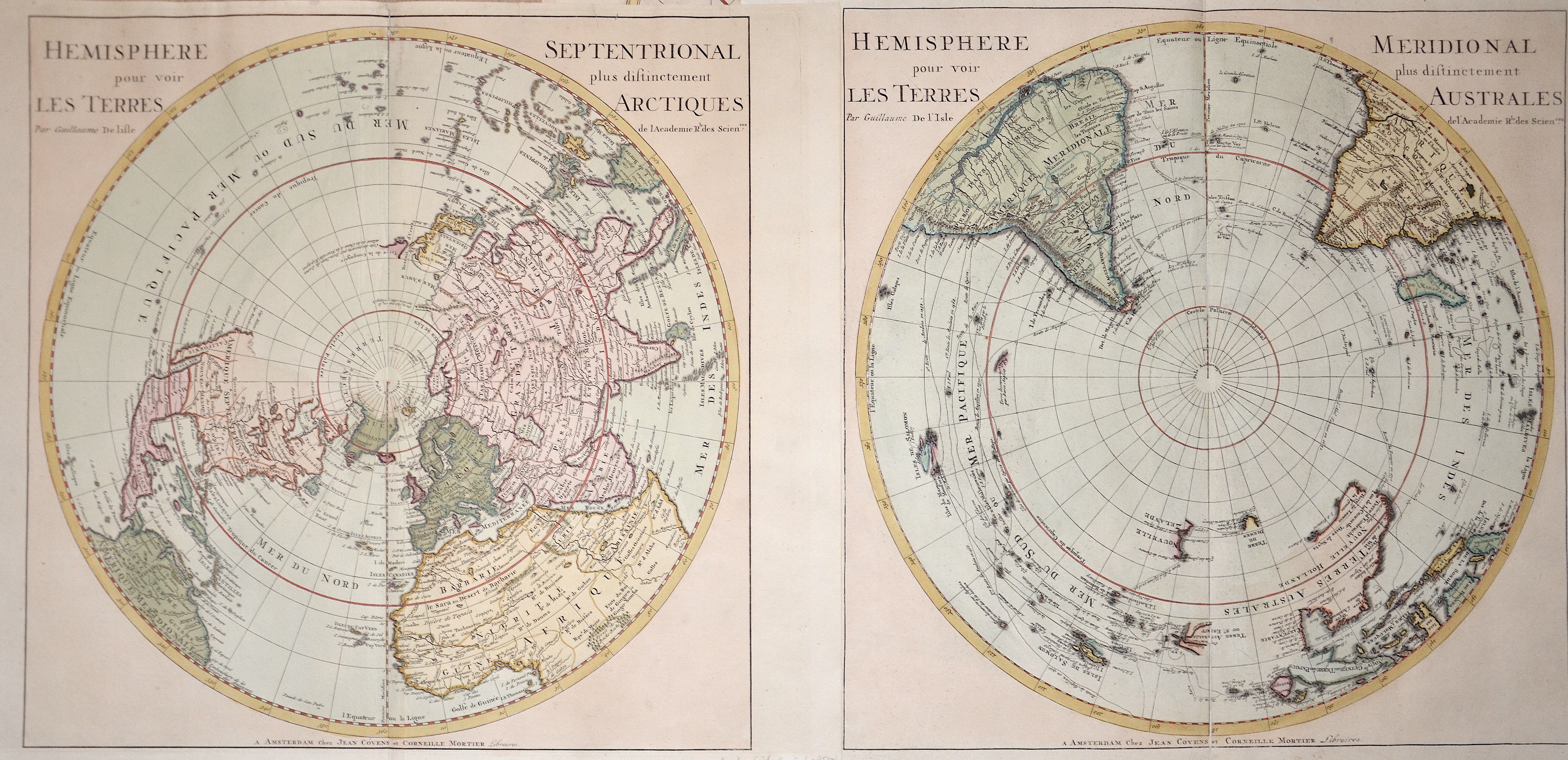
Hemisphere Septenrional” & “Hemisphere Meridional

| Article ID | PO0228 |
Title | Hemisphere Septenrional” & “Hemisphere Meridional |
Description | 2 maps with the northern and southern hemisphere shown in a polar projection. |
| Year | dated 1714 |
Artist | L´Isle, de /Covens & Mortier (1675-1726) |
Guillaume De L’Isle (1675–1726) was a renowned French cartographer famous for his accurate maps of Europe, the Americas, and Africa. He joined the French Académie Royale des Sciences, signing his maps as “Géographe de l’Académie,” and later became Premier Géographe du Roi in 1718, teaching geography to the Dauphin. De L’Isle mostly worked from his office, relying on a strong network of traveler reports and scientific updates, ensuring his maps were precise and honest. He openly noted uncertain information, such as a disputed river in Louisiana. In 1700, he won a legal case against Jean-Baptiste Nolin for plagiarism. Unlike the Sanson workshop, which often published outdated maps, De L’Isle focused on up-to-date, scientifically grounded cartography. | |
Historical Description | South Pole: Situated on the continent of Antarctica, it is the site of the United States Amundsen–Scott South Pole Station, which was established in 1956 and has been permanently staffed since that year. The Geographic South Pole is distinct from the South Magnetic Pole, the position of which is defined based on Earth's magnetic field. The South Pole is at the center of the Southern Hemisphere. In 1820, several expeditions claimed to have been the first to have sighted Antarctica. The basic geography of the Antarctic coastline was not understood until the mid-to-late 19th century. American naval officer Charles Wilkes claimed correctly that Antarctica was a new continent, basing the claim on his exploration in 1839–40, while James Clark Ross, in his expedition of 1839–43, hoped that he might be able to sail all the way to the South Pole. British explorer Robert Falcon Scott on the Discovery Expedition of 1901–04 was the first to attempt to find a route from the Antarctic coastline to the South Pole. The first men to reach the Geographic South Pole were the Norwegian Roald Amundsen and his party on December 14, 1911. Amundsen named his camp Polheim and the entire plateau surrounding the Pole King Haakon VII Vidde in honour of King Haakon VII of Norway. North Pole: While the South Pole lies on a continental land mass, the North Pole is located in the middle of the Arctic Ocean amid waters that are almost permanently covered with constantly shifting sea ice. Attempts to reach the North Pole began in the late 19th century, with the record for "Farthest North" being surpassed on numerous occasions. The first undisputed expedition to reach the North Pole was that of the airship Norge, which overflew the area in 1926 with 16 men on board, including expedition leader Roald Amundsen. Three prior expeditions – led by Frederick Cook (1908, land), Robert Peary (1909, land) and Richard E. Byrd (1926, aerial) – were once also accepted as having reached the Pole. However, in each case later analysis of expedition data has cast doubt upon the accuracy of their claims. |
| Place of Publication | Amsterdam |
| Dimensions (cm) | 46 x 46 |
| Condition | Very good |
| Coloring | colored |
| Technique | Copper print |