

Adina Sommer
Antique and Contemporary Art
Winzerer Str. 154
80797 München
telephone
+49 89 304714
business hours:
by appointment
Email
![]()


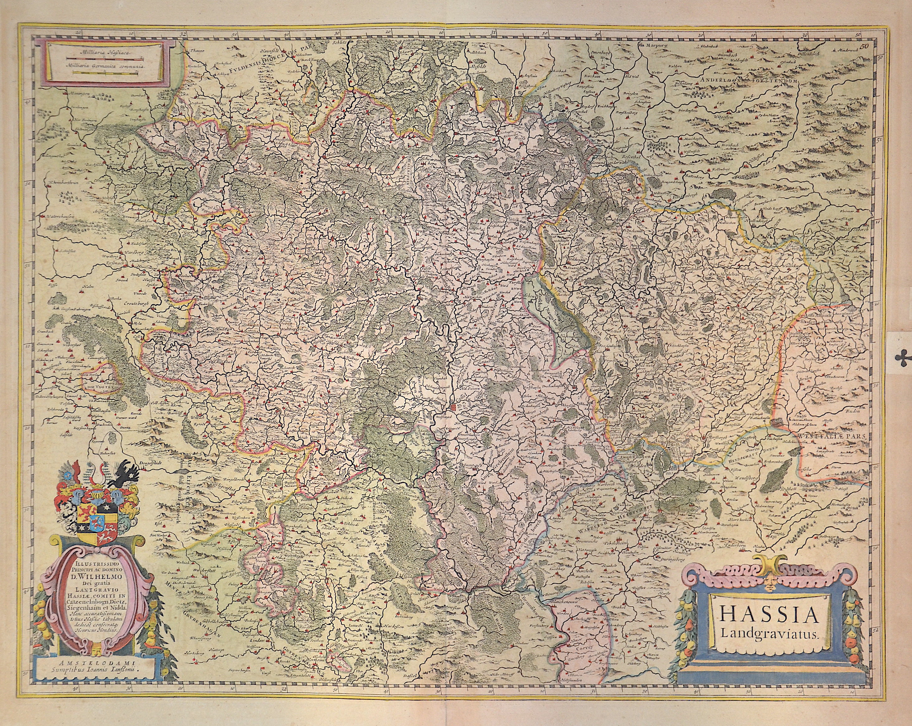
Hassia Landgraviatus.

| Article ID | EUD0047 |
Title | Hassia Landgraviatus. |
Description | Map shows the area between Alsfeld, Eisenach and Northeim, a title cartouche and the coat of arms of the Landgraviate of Hesse. |
| Year | ca. 1638 |
Artist | Janssonius/Mercator-Hondius, H. (1588-1664) |
Johannes Janssonius (Jansson),( 1588- 1664) Amsterdam was born in Arnhem, the son of Jan Janszoon the Elder,a publisher and bookseller. In 1612 he married Elisabeth de Hondt, the daughter of Jodocus Hondius. He produced his first maps in 1616 of France and Italy. In 1623 Janssonius owned a bookstore in Frankfurt am Main, later also in Danzig, Stockholm, Copenhagen, Berlin, Königsberg, Geneva and Lyon. In the 1630s he formed a partnership with his brother in law Henricus Hondius, and together they published atlases as Mercator/Hondius/Janssonius. Under the leadership of Janssonius the Hondius Atlas was steadily enlarged. Renamed Atlas Novus, it had three volumes in 1638, one fully dedicated to Italy. 1646 a fourth volume came out with English County Maps, a year after a similar issue by Willem Blaeu. Janssonius' maps are similar to those of Blaeu, and he is often accused of copying from his rival, but many of his maps predate those of Blaeu and/or covered different regions. By 1660, at which point the atlas bore the appropriate name Atlas Major, there were 11 volumes, containing the work of about a hundred credited authors and engravers. It included a description of most of the cities of the world (Townatlas), of the waterworld (Atlas Maritimus in 33 maps), and of the Ancient World (60 maps). The eleventh volume was the Atlas of the Heavens by Andreas Cellarius. Editions were printed in Dutch, Latin, French, and a few times in German. | |
Historical Description | The history of Hesse in the 16th to 19th centuries was shaped by significant political, religious, and social changes. This period was marked by the Reformation, the Thirty Years' War, the Napoleonic Wars, and changes within the German Confederation. In the 16th century, Hesse was a state in the Holy Roman Empire. The Reformation began in Hesse in 1527, when Landgrave Philip the Magnanimous of Hesse became one of the first German princes to adopt the Lutheran faith. As a result, Hesse became a center of the Reformation, which brought profound religious and political changes to the region. In the 17th century, Hesse was affected by the Thirty Years' War (1618–1648). The war, which plunged Europe into a devastating conflict, also had catastrophic consequences for Hesse. In particular, the mid-century saw economic decline and social hardships. The Peace of Westphalia (1648) ended the war, but its economic and political repercussions were felt for a long time. In the 18th century, Hesse began to stabilize. The state was an important part of the Holy Roman Empire and was governed by the Landgraves of Hesse-Kassel. Hesse-Kassel was a prosperous region, particularly benefiting from tax revenues generated through trade in iron and salt. The early 19th century was shaped by the Napoleonic Wars and the resulting upheavals. In 1806, Hesse-Kassel joined the Confederation of the Rhine and came under French influence. After the end of the Napoleonic era and the decisions of the Congress of Vienna (1815), Hesse-Kassel came under the control of the House of Hesse again but became part of the German Confederation, a loose union of German states. In 1866, Hesse took part in the Austro-Prussian War and, after the conflict, was annexed by Prussia and integrated into the Prussian province of Hesse-Nassau. By the end of the 19th century, Hesse had become part of the newly unified German Empire, established in 1871 under Prussian leadership, and the region experienced a phase of industrialization and modernization. |
| Place of Publication | Amsterdam |
| Dimensions (cm) | 44 x 56 cm |
| Condition | Very good |
| Coloring | original colored |
| Technique | Copper print |