

Adina Sommer
Antique and Contemporary Art
Winzerer Str. 154
80797 München
telephone
+49 89 304714
business hours:
by appointment
Email
![]()


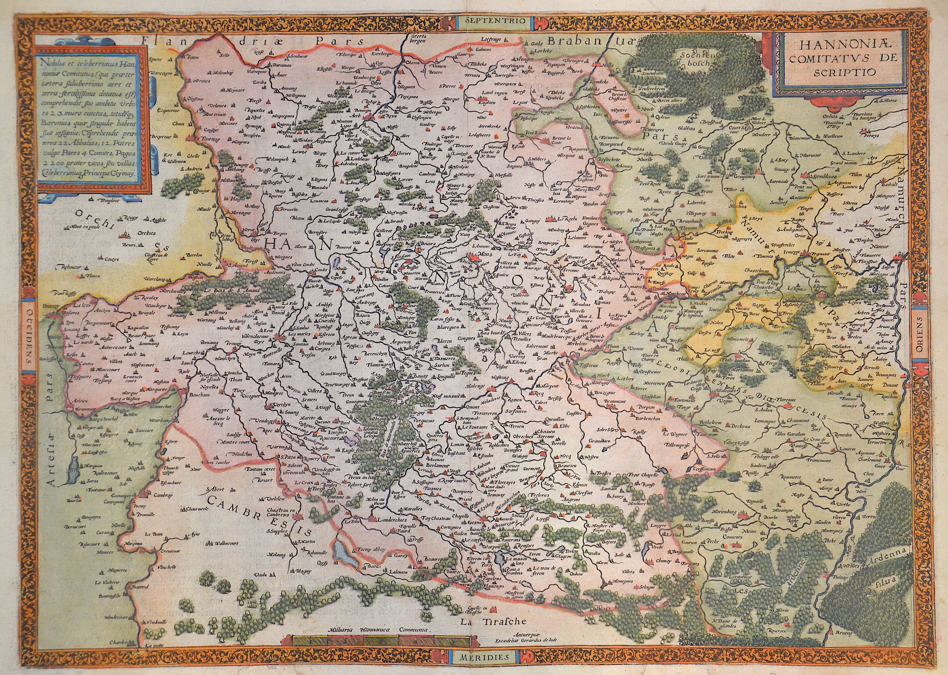
Hannoniae Comitatus de scriptio

| Article ID | EUB4835 |
Title | Hannoniae Comitatus de scriptio |
Description | Map shows the province of Hainaut in Belgium (partly France) with the city of Mons, Tournai, Ath, Charleroi, Walcourt, Maubeuge, Aymries, Dour, Valenciennes, La Cateau-Cambrésis and many more. Furthermore, two scroll cartouches and a mileage scale. |
| Year | ca. 1593 |
Artist | Jode, de (1570-1634) |
Gerard de Jode (1509–1591)Antwerp, was a cartographer, engraver and. In 1547 he was admitted to the Guild of St. Luke, and began his work as a publisher and printseller. He often printed the works of other cartographers including Gastaldi's map of the world in 1555, Jacob van Deventer's map of Brabant in 1558, Ortelius' eight sheet map of the world in 1564, and maps by Bartholomeus Musinus and Fernando Alvares Seco. His most outstanding work is a two volume atlas Speculum Orbis Terrarum published in 1578. It was aimed at competing with another atlas, Theatrum Orbis Terrarum by Ortelius, published eight years earlier in 1570. The competing atlas had become so popular by the time he finally published his own atlas however, that his version never sold well, despite his outstanding reputation. Only about a dozen examples have survived. Gerard de Jode made plans for another enlarged edition, which was uncompleted at his death in 1591. His son Cornelis de Jode took over and published the Speculum Orbis Terrae in 1593. This never sold well . Scholars consider many of de Jode's maps to be superior to those of Ortelius, both in detail and style. In constructing his world map, HEMISPHERIUM AB AEQUINOCTIALI LINEA, AD CIRCULUM POLI ANTARCTICI, published in 1593, Gerard de Jode was strongly influenced by Guillaume Postel’s 1581 polar planisphère, Polo aptata Nova Charta Universi. Gerard de Jode was probably the maker of a globe made in Antwerp that also owes much to the cosmographic ideas of Guillaume Postel. | |
Historical Description | As the province of Belgica - a name introduced by Caesar - what is now Belgium experienced many rulers. From the High Middle Ages to the early modern period, the cities of Flanders with their cloth industries represented one of the two centers of the European economy. Politically, the individual territories came under the House of Burgundy, which was inherited by the Habsburgs in 1477. In 1579 the Catholic Union of Arras and the Calvinist-Protestant Union of Utrecht were formed. The provinces of the Union of Utrecht broke away from Spain in 1581 and founded the Republic of the Seven United Provinces, whose independence was recognized in the Peace of Westphalia of 1648 after the end of the Eighty Years War. The provinces of the Union of Arras, Flanders and Brabant were administered as the Spanish Netherlands by a Spanish governor. After the extinction of the Spanish Habsburgs (1700) and the resulting War of the Spanish Succession, the Austrian Netherlands came under the rule of the Austrian Habsburgs in 1714. As a result of the absolutist-centralistic efforts of the Austrian ruler Joseph II, the Brabant Revolution came in 1789 and the short-lived United Belgian States. Revolutionary France annexed the Austrian Netherlands between 1792 and 1794, followed by incorporation into the French Republic in 1795. At the Congress of Vienna (1815) the provinces were awarded to the Netherlands. After the Belgian Revolution, the country gained independence in 1830. |
| Place of Publication | Antwerp |
| Dimensions (cm) | 36 x 50 cm |
| Condition | Missing parts external margin restored |
| Coloring | original colored |
| Technique | Copper print |