

Adina Sommer
Antique and Contemporary Art
Winzerer Str. 154
80797 München
telephone
+49 89 304714
business hours:
by appointment
Email
![]()


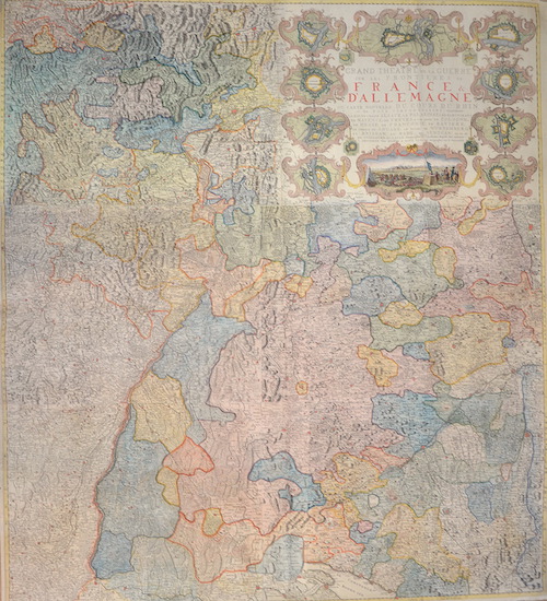
Grand Theatre de la Guerre sur les Frontieres de France et D’Allemagne ou Carte nouvelle du Cours du Rhin

| Article ID | EUD4754 |
Title | Grand Theatre de la Guerre sur les Frontieres de France et D’Allemagne ou Carte nouvelle du Cours du Rhin |
Description | Magnificent, large wall map shows Baden-Württemberg, Swabia and Hesse with the course of the Rhine from Lake Constance through Schaffhausen, Basel, Strasbourg, Worms, Mainz, Kassel, Koblenz and Bonn. Top right is the title framed with 14 city maps (Strasbourg, Koblenz, Landau, Breisach, Mainz, Mannheim, Heilbronn, Freiburg, etc.) of which a view of "Siege de Philipsbourg" in France. Issued in: Atlas nouveau, contenant toutes les parties su Monde, ou sont exactement remarquees les empires, monarchies, royaumes, etats, republiques, &c. Par Guillaume de l'Isle. Premier Geographe de sa Majeste. A Amsterdam, Chez Jean Covens & Corneille Mortier, sur le Vygendam. |
| Year | ca. 1742 |
Artist | Ottens/ De L´Isle (1700-1750) |
Joachim Ottens (1663 – 1719). Family of Publishers in Amsterdam and his sons Josua and Renier. Joachim Ottens .Joachim Ottens was the founder of the firm and worked before for Frederick de Wit . Joachim died only a few years later, his sons Renier and Joshua took over the firm and presided over its most prolific period. | |
Historical Description | The concept of Germany as a distinct region in central Europe can be traced to Roman commander Julius Caesar, who referred to the unconquered area east of the Rhine as Germania, thus distinguishing it from Gaul (France), which he had conquered. In the High Middle Ages, the regional dukes, princes and bishops gained power at the expense of the emperors. Martin Luther led the Protestant Reformationagainst the Catholic Church after 1517, as the northern states became Protestant, while the southern states remained Catholic. The two parts of the Holy Roman Empire clashed in the Thirty Years' War (1618–1648). 1648 marked the effective end of the Holy Roman Empire and the beginning of the modern nation-state system, with Germany divided into numerous independent states, such as Prussia, Bavaria and Saxony. |
| Place of Publication | Amsterdam |
| Dimensions (cm) | 139,5 x 124 cm |
| Condition | Printed on 6 sheets joined together, folds partly restored |
| Coloring | original colored |
| Technique | Copper print |