

- Alsace
- Aquitaine
- Auvergne
- Bourgogne
- Bourgogne-Franche-Comte
- Brittany
- Centre
- Champagne
- France Islands
- Gascogne
- Gironde
- Hauts-de-France
- Ile de France
- Languedoc
- Lothringen
- Midi-Pyrénées
- Nivernais
- Nord-Pas-de-Calais
- Normandie
- Occitanie
- Pas-de-Calais
- Pays de la Loire
- Picardie
- Poitou-Charentes
- Provence-Alpes-Cote d Azur
- Pyrénées
- Rhone- Alpes
- Saintonge
- Savoyen
- Tourain
- Westcoast
Adina Sommer
Antique and Contemporary Art
Winzerer Str. 154
80797 München
telephone
+49 89 304714
business hours:
by appointment
Email
![]()


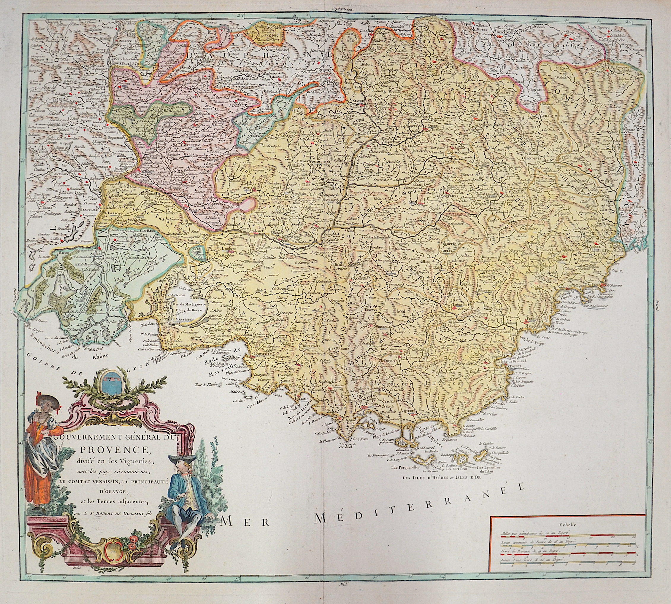
Gouvernement General de Provence divise en fes Vigueries,..

| Article ID | EUF4626 |
Title | Gouvernement General de Provence divise en fes Vigueries,.. |
Description | Map shows the Provenceand the beautiful Cote d´Azur in France, with magnificent cartouche. |
| Year | ca. 1750 |
Artist | Vaugondy,de (1723-1786) |
Didier Robert de Vaugondy (1723 -1786) also known as Le Sieur or Monsieur Robert, and his son, were leading cartographers in France during the 18th century. In 1757, Gilles and Didier Robert De Vaugondy published The Atlas Universel, one of the most important atlases of the 18th century. To produce the atlas, the Vaugondys integrated older sources with more modern surveyed maps. They verified and corrected the latitude and longitude of many regional maps in the atlas with astronomical observations. The older material was revised with the addition of many new place names. In 1760, Didier Robert de Vaugondy was appointed geographer to Louis XV. Gilles and Didier Robert De Vaugondy produced their maps and terrestrial globes working together as father and son. Globes of a variety of sizes were made by gluing copperplate-printed gores on a plaster-finished papier-mache core, a complicated and expensive manufacturing process, employing several specialists. In some cases it is uncertain whether Gilles or Didier made a given map. Gilles often signed maps as M.Robert, while Didier commonly signed his maps as ""Robert de Vaugondy"", or added ""fils"" or ""filio"" after his name. The Robert de Vaugondys were descended from the Nicolas Sanson family through Sanson's grandson, Pierre Moulard-Sanson. From him, they inherited much of Sanson's cartographic material, which they combined with maps and plates acquired after Hubert Jaillot's death in 1712 to form the basis the Atlas Universel. | |
Historical Description | Around 600 BC began the systematic colonization of the coast of Provence by Greeks from the Asia Minor city of Phocaea. The Phocaeans had come under pressure from the Persians and, during their voyages along the Mediterranean coast, had discovered the port basin of the later city of Marseille, created by nature. There is a legend according to which the Celtic king Nann was looking for a husband for his daughter Gyptis and gave his daughter the free choice. She chose a beautiful Greek stranger. On this they are said to have founded the city of Marseilles, then Massalia (later Massilia). This city experienced a tremendous increase in population. The city slowly began to develop into a large trading settlement, trading even with the distant Celtic tribes in what is now northern Germany. Above all, the good location by the sea made Massalia so successful. After almost 600 years as a Roman province, the land was conquered by the Visigoths in 470/477. From 934 on, Provence belonged to the united Kingdom of Burgundy, and from 1032 to the Holy Roman Empire due to an inheritance treaty that came to fruition. In 1498, the part of Provence that belonged to France at that time was incorporated into the Domaine royal, from 1660 the territory was administered like a province and in 1789, in the course of the French Revolution, it was divided into departments. Only the parts of Provence located in the Maritime Alps (also called the Maritime Alps), which had become independent over time (for example, the County of Nice and the Principality of Monaco), remained with the Holy Roman Empire, and some of them joined France only later. |
| Place of Publication | Paris |
| Dimensions (cm) | 48,5 x 54 cm |
| Condition | Some restoration at centerfold |
| Coloring | original colored |
| Technique | Copper print |