

Adina Sommer
Antique and Contemporary Art
Winzerer Str. 154
80797 München
telephone
+49 89 304714
business hours:
by appointment
Email
![]()


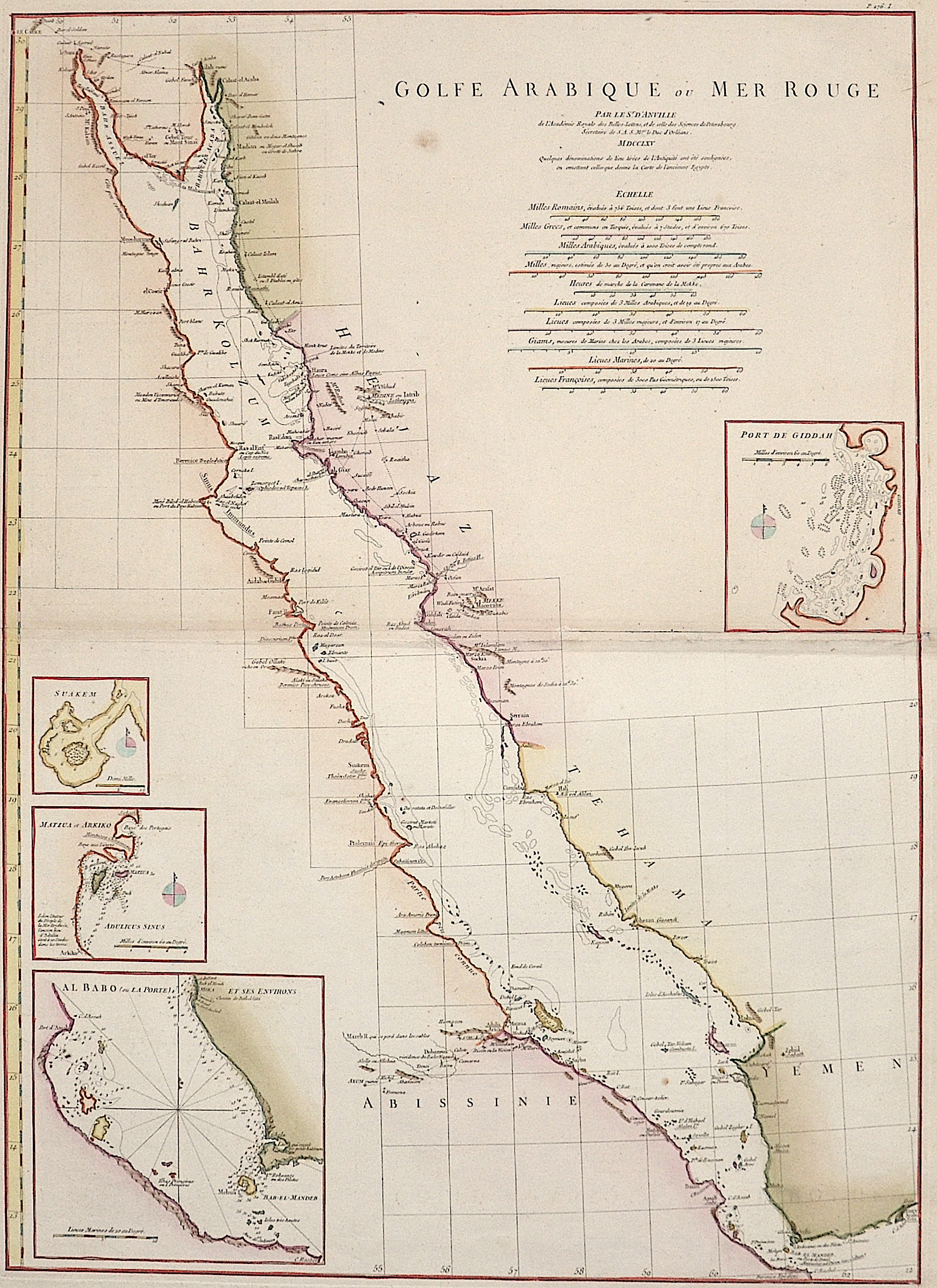
Golfe Arabique ou Mer Rouge

| Article ID | ASA1069 |
Title | Golfe Arabique ou Mer Rouge |
Description | Map depicts the Red Sea with coasts of Egypt, Sudan and the Arabian peninsula. 4 inset maps, 1. The city of Bur Sudan (Suakem), 2. The island Matzua and Arkiko in Sudan, 3. The harbour of Dschidda in Saudi-Arabia, 4. The strait of Bab-el-Mandeb with the island Perim. |
| Year | dated 1765 |
Artist | Anville´d (1697-1782) |
Jean Baptiste Bourguignon d'Anville (1697 -1782), was a French geographer and the reformer of old and new cartography. Bourguignon d'Anville devoted himself early to geographical studies, already in the age of 21 became a royal geographer.With this appointment he later rose as a private secretary of Louis, Duke of Orléans. He published 211 maps and became a member of the Académie des sciences in 1773. His valuable map collection, consisting of 10,500 numbers, was purchased for the Royal Library of Paris, now the Bibliothèque Nationale de France. Jean Baptiste Bourguignon d'Anville, was a geographer and cartographer who greatly improved the standards of map making. Particularly valuable are his maps of ancient geography, which are characterized by careful, accurate work and are largely based on original research. He left unknown areas of continents blank and noted dubious information as such; compared to the elaborate maps of his predecessors, his maps seemed empty. His first serious map, that of ancient Greece, was published when he was fifteen years old. At the age of twenty-two he was appointed one of the king's geographers and began to attract the attention of the first authorities. D'Anville's studies included everything geographical in the world's literature as far as he could find it: To this end, he searched not only ancient and modern historians, travelers, and storytellers of every kind, but also poets, orators, and philosophers. One of his favorite themes was to reform geography by putting an end to blind copying of older maps, by testing the generally accepted positions of places by a rigorous examination of all descriptive authority, and by excluding from cartography any name that was inadequately supported. | |
Historical Description | Arabia, an early empire on the largely uninhabitable Arabian Peninsula, was the legendary Saba in the south, which at times ruled all of southwest Arabia and had colonies in Eritrea and Tanzania. In the seventh century, Islam became the dominant religion on the peninsula. The Islamic prophet Muhammad was born in Mecca around 570 and began preaching in the city in 610, but immigrated to Medina in 622. Mohammed founded a new unified polity on the Arabian Peninsula which, under the subsequent caliphates of Rashidun and Umayyads, experienced a century of rapid expansion of Arab power far beyond the Arabian Peninsula in the form of a vast Muslim Arab Empire with an expanding sphere of influence from the northwest Indian subcontinent across Central Asia, the Middle East, North Africa, South Italy and the Iberian Peninsula to the Pyrenees. Despite its spiritual significance, Arabia soon became politically a fringe region of the Islamic world, with the main medieval Islamic states located at different times in cities as distant as Damascus, Baghdad and Cairo. However, from the 10th century (and indeed until the 20th century) the Hashemite Sharifs of Mecca retained a state in the most developed part of the region, the Hejaz. Their domain originally included only the holy cities of Mecca and Medina, but was extended to the rest of the Hejaz in the 13th century. Although the Sharifs in the Hejaz exercised largely independent authority, they were usually subject to the suzerainty of one of the great Islamic empires of the time. In the Middle Ages, this included the Abbasids of Baghdad and the Fatimids, Ayyubids and Mamluks of Egypt. |
| Place of Publication | Paris |
| Dimensions (cm) | 67 x 48 |
| Condition | Some restoration at centerfold |
| Coloring | original colored |
| Technique | Copper print |