

Adina Sommer
Antique and Contemporary Art
Winzerer Str. 154
80797 München
telephone
+49 89 304714
business hours:
by appointment
Email
![]()


Geographia Cl. Ptolemaei Alexandrini Olim Bilibaldo Pirckheimherio traslata,.. A Iosepho Moletio Mathematico
| Article ID | B0296 |
Title | Geographia Cl. Ptolemaei Alexandrini Olim Bilibaldo Pirckheimherio traslata,.. A Iosepho Moletio Mathematico |
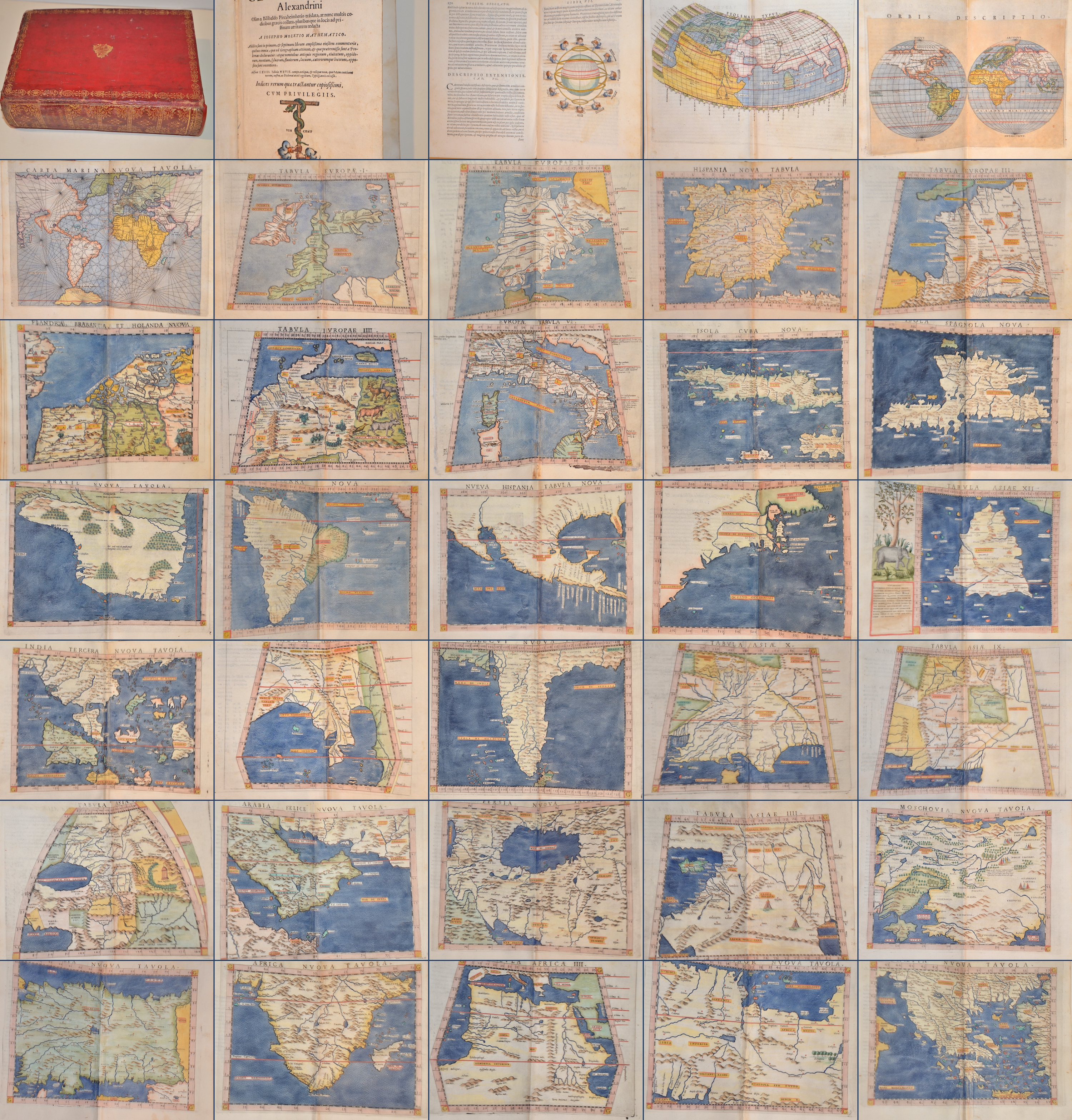
Magnificent and rare atlas, published by Vincentio Valgrisi (1490-??) after Claudius Ptolomeus, text by Giuseppe Moleto. 64 numbered double-page maps of which 27 are Ptolemaic maps showing the ancient world, including the “Old World”. 37 “modern” maps including 2 world maps and several woodcut diagrams, illustrations and decorative initials. Title page with Valgrisi's printer's mark, a tau cross with a snake coiled around it, held by two hands and inscribed with his name “Vincent”. BOOK LIST: Title page, preface “Aloysio Cornelio Cardinali”, Claudii Ptolemaei Alexandrini Geograficae enarrationis Liber Primus. pp. 1 - 112, Cl. Ptolomaei Geographicae enarrationis, Liber II-VIII pp. 1 - 286. 64 numbered maps, 63 pages index. The text of this atlas was written by Giuseppe Moleto (1531-1588), an Italian mathematician. It is based on the translation by Wilibald Pirckheimer from 1525. Moleto relies on the enlarged maps by Ruscelli in his edition of 1561, which in turn are based on those by Jacopo Gastaldi. Moleto also included some of Girolamo Ruscelli's innovations from his own edition: the world map with the double hemisphere and the “Carta Marina Nuova Tavola”, a rare sea chart of the world. Ruscelli also produced a revised version of the Zeno map of the Arctic, which was first published in 1558. The Zeno map describes the alleged voyage of the author's ancestors in the 1390s to Greenland, Iceland, the mythical islands of Friesland and Icaria and what is now thought to be Newfoundland and Labrador. While Zeno shows the connection between Greenland and Norway, Ruscelli updated the map by eliminating this land bridge. Despite its inaccuracies and the inclusion of mythical lands, the Zeno map remained the predominant map of the Arctic and Greenland for many years. Six other maps of the New World show the South American continent, Brazil, Central America and the Baja Peninsula, the east coast of North America, Cuba and Hispaniola. Moleto contrasts the Ptolemaic maps with those of the time, making it easy to compare old and new. Some small restorations at the top fold of the double maps and from map 33 onwards a slight tidemark at the top. | |
| Year | c. 1562 |
Artist | Ptolemy/ Valgrisi (1490-??) |
Vincenzo Valgrisi (born around 1490 near Lyon), also known by the Latin name Vicentius Valgrisius, was a French-born printer who published around 200 works over the course of his career, including the atlas “Geographia Cl. Ptolemaei Alexandrini Olim Bilibaldo Pirckheimherio traslata, A Iosepho Moletio Mathematico”. Most of his works were published in Venice, including this atlas. Only a short period from 1549 to 1551 was published in Rome. Many of the books published in the Venetian bookshop bear the imprint “Ex Officina Erasmiana”. In 1570, he was fined by the Roman Inquisition for selling forbidden books. His warehouse contained 1,150 volumes of banned works, including 400 copies of Simolachri, historie e figure de la morte, Valgrisi's imitation of Hans Holbein's Dance of Death. | |
Historical Description | The term Atlas goes back to Gerhard Mercator and his work Atlas sive Cosmographicae Meditationes de Fabrica Mundi et Fabricati Figura, published posthumously in 1595 ("Atlas or cosmographic considerations about the creation of the world and the form of it"). In the foreword, Mercator explains the naming of his work in relation to the mythical King Atlas of Mauritania, who appears to Diodorus Siculus as a wise connoisseur of the stars and their spherical shape. Atlas of Mauritania belongs to the legendary circle around the Titan Atlas. As early as 100 AD, Marinus von Tyrus introduced the grad network card. Around 50 years later, Claudius Ptolemy made a kind of atlas. The beginning of the great voyages of discovery heralded a new development in cartography. Until the 15th century, maps were based on the classic works of Ptolemy (2nd century AD) and atlases, any collection of linked maps. The first atlas, in the sense of a book that was published in a specific edition with cards of the same format that were specially designed or produced for this edition, was Theatrum Orbis Terrarum (i.e. world stage) by Abraham Ortelius (1527–1598) , 1570 appeared in Antwerp, a tome with 70 current maps, which were coordinated in terms of content. 41 editions are known, which were published in different languages until 1612. Such an atlas was that of Gerhard and Cornelis de Jode: Speculum Orbis Terrarum. The first to use Atlas as a title for a similar work was Gerhard Mercator (1512–1594, still known from the projection of the same name, 1569), who was born in Rupelmonde in Flanders and who wrote the atlas published shortly after his death, sive Cosmographicae Meditationes de Fabrica Mundi and Fabricati Figura. France: The golden age is called the heyday of the 17th century in Holland. But the end of this era was also the end of the leading position of the Dutch in the field of Atlas cartography. Atlases were reissued, but not kept up to date. The dominance was taken over by France, which was then predominant in science and art. Already in 1652 Nicolas Sanson (1600–1667) and Pierre Mariette (1603–1657) published an atlas, which in 1658 was followed by the Cartes générales de toutes les parties du monde (Paris, 1658, with 113 cards, six more editions until 1676) which the Dutch atlases surpassed in reliability and timeliness. Triangulation has greatly improved the accuracy of the maps. A first example of this is the atlases by Nicolas de Fer (1646-1720), who wrote his Atlas curieux ou le monde dressé (Paris, 1699, 2 vols with 295 panels), based on the latest survey data from the French Académie des sciences and these Also had data checked by astronomers. The Atlas Nouveau by Guillaume Delisle (1675–1726), which appeared in Amsterdam in 1730, had 56 cards; in later editions extended to 138. Delisle maintained relationships with scholars and authorities around the world (including the Russian Tsar Peter the Great) with the intention of acquiring original templates for his cards. The famous cartographer Jean-Baptiste Bourguignon d’Anville (1697–1782) not only used up-to-date geodetic data, but also, after a critical examination, reports from explorers. His Atlas Général (1780, 46 sheets) is known. Rigobert Bonne (1727–1794), who is still famous due to the map projection named after him, made a name for himself with the Atlas modern ou collection de cartes sur toutes les parties du globe terrestre (Paris, 1771) and with Nicolas Desmarest (1725–1815) wrote a three-volume atlas for the new edition (Paris, 1787/88) published by Panckouke of the famous Encyclopédie by Diderot and d'Alembert. England: The most famous 18th century English atlases were New and Compleat Atlas (1720, 27 maps) by Herman Moll, New General Atlas (1721, 48 plates) by Senex, General Atlas (1770) and New Universal Atlas (1790) by Kitchin, General Atlas of the four grand quarters of the World (1778, later General Atlas of the World) von Faden, u. a. However, they cannot be compared to the French atlases in the same period. Germany:World map from the Atlas portatilis (1717–1780) by Melissantes and Johann Christoph Weigel. The scientific value of the atlases that appeared in Germany in the 18th century was limited. The best-known cartographer and publisher was Johann Baptist Homann (1664–1724) from Nuremberg, who published several large atlases, such as the Great Atlas of the Whole World (1716, 126 maps). His heirs expanded the publishing house with a 3-volume Atlas geographicus maior (1740), which also contained works by others. A student of Homann, Mattias Seutter (1678–1756) from Augsburg published various atlases, for example an Atlas Geographicus (1720) with 46 maps, which was published several times. In general, however, Seutter's works are not very original and mostly reproductions. The small two-part ATLAS PORTATILIS by Johann Christoph Weigel (copperplate engraver) and Johann Gottfried Gregorii alias MELISSANTES (text author) underwent several editions between 1717/1723 and 1780. The second part, called Continuirter ATLAS PORTATILIS GERMANICUS, was somewhat accurate due to the partial use of the good templates by Adam Friedrich Zürner, which also explains the decades of use of these handy pocket and school atlases. Austria: It was only in Austria at the end of the 18th century that there was talk of its own Atlas culture. The best-known works are Schrämbl's General Great Atlas (Vienna, 1786 and later, 133 maps) and probably the most name-rich Atlas of all time, the scene of the five parts of the world, published by Franz Johann Joseph von Reilly (Vienna, 1789 and later) 830 plates that were not fully finished. |
| Place of Publication | Venice |
| Dimensions (cm) | 23 x 16,5 cm |
| Condition | Binding in calfskin with gold embossing and gilt edges. |
| Coloring | original colored |
| Technique | Woodcut |