

Adina Sommer
Antique and Contemporary Art
Winzerer Str. 154
80797 München
telephone
+49 89 304714
business hours:
by appointment
Email
![]()


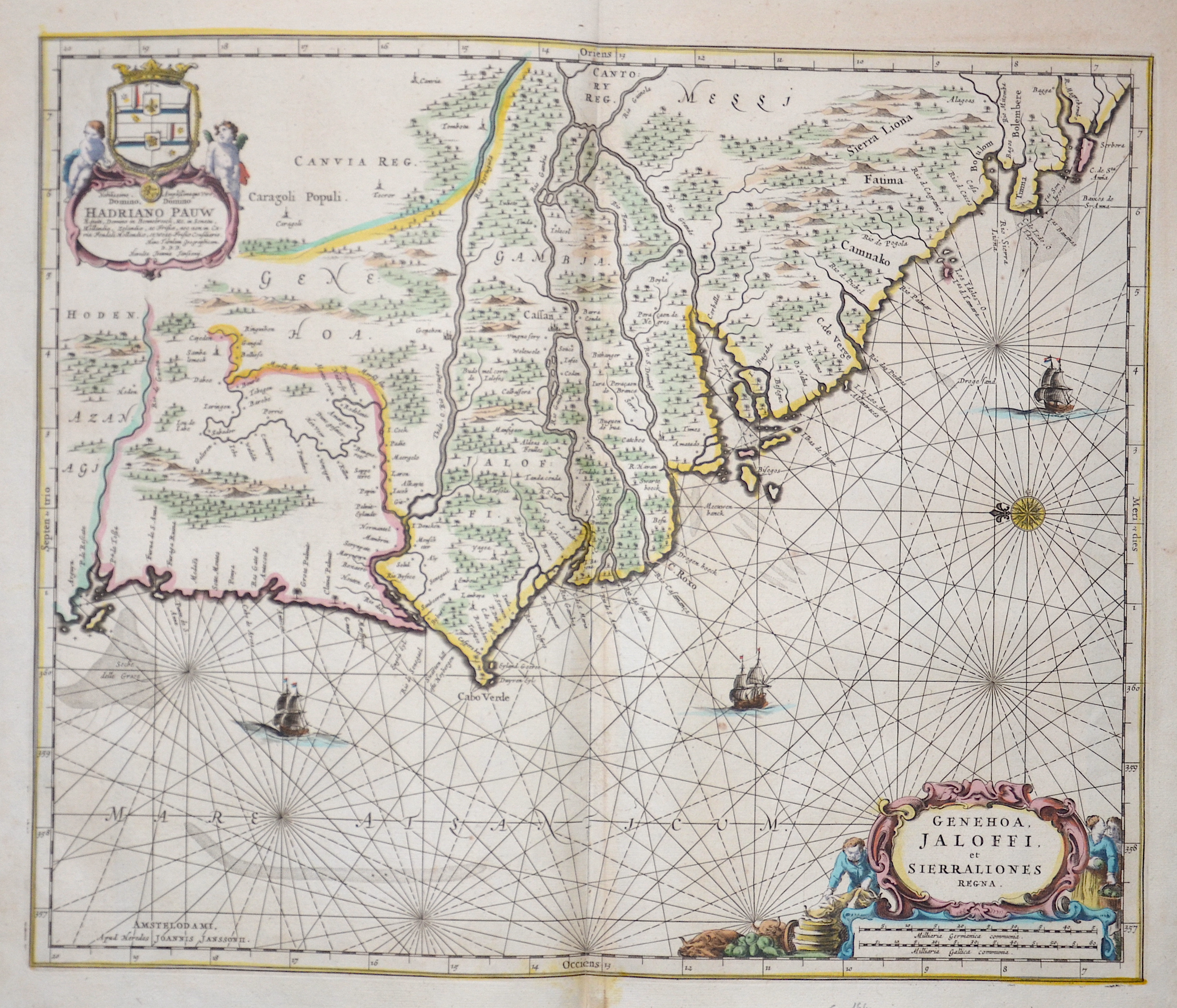
Genehoa, Jaloffi, et Sierraliones Regna.

| Article ID | AF0487 |
Title | Genehoa, Jaloffi, et Sierraliones Regna. |
Description | Map shows Gambia, Senegal and partly Sierra Leone in Africa with two magnificent cartouches, three sailing ships and a wind rose. |
| Year | ca. 1660 |
Artist | Janssonius (1588-1664) |
Johannes Janssonius (Jansson),( 1588- 1664) Amsterdam was born in Arnhem, the son of Jan Janszoon the Elder,a publisher and bookseller. In 1612 he married Elisabeth de Hondt, the daughter of Jodocus Hondius. He produced his first maps in 1616 of France and Italy. In 1623 Janssonius owned a bookstore in Frankfurt am Main, later also in Danzig, Stockholm, Copenhagen, Berlin, Königsberg, Geneva and Lyon. In the 1630s he formed a partnership with his brother in law Henricus Hondius, and together they published atlases as Mercator/Hondius/Janssonius. Under the leadership of Janssonius the Hondius Atlas was steadily enlarged. Renamed Atlas Novus, it had three volumes in 1638, one fully dedicated to Italy. 1646 a fourth volume came out with English County Maps, a year after a similar issue by Willem Blaeu. Janssonius' maps are similar to those of Blaeu, and he is often accused of copying from his rival, but many of his maps predate those of Blaeu and/or covered different regions. By 1660, at which point the atlas bore the appropriate name ""Atlas Major"", there were 11 volumes, containing the work of about a hundred credited authors and engravers. It included a description of ""most of the cities of the world"" (Townatlas), of the waterworld (Atlas Maritimus in 33 maps), and of the Ancient World (60 maps). The eleventh volume was the Atlas of the Heavens by Andreas Cellarius. Editions were printed in Dutch, Latin, French, and a few times in German. | |
Historical Description | The fertile banks of the Gambia River have been populated for millennia. The Carthaginian Hanno the Navigator gave a written record around 470 BC, in the report of his trip to West Africa. The connection to the Mediterranean region only broke down with the fall of the Roman Empire and the spread of Islam. Arab traders provided the first written accounts of the Gambia region in the 9th and 10th centuries. During the tenth century, Muslim merchants and scholars founded communities in several West African trade centers. Both groups established trade routes between the Sahara areas, which led to a large export of locals as slaves, along with gold and ivory, and to the import of industrial goods. In the middle of the 15th century, numerous voyages of discovery initiated by Henry the Navigator led to the western tip of Africa. In the following years, Portuguese traders took the route by ship as a means of transport. At that time, Gambia was part of the Mali Empire. In 1618, King James I granted a British company the privilege to trade with The Gambia and the Gold Coast, today's Ghana. The Netherlands and the Duchy of Courland also had short-term colonies in what is now the Gambia. From the late 17th to the late 18th century, England and France fought over political and economic rule over the rivers in Senegal and The Gambia. The Paris Peace Treaty of 1763 gave Great Britain control of the Gambia, the French only got a small enclave around Albreda north of the river. This was ceded to Great Britain in 1857. In 1816 the English built a military base in Bathurst (now Banjul). The following years, Banjul was temporarily under the British Governor General in Sierra Leone. It wasn't until 1888 that Gambia became an independent colony. The border between the French colony of Senegal and the Gambia was finally established. |
| Place of Publication | Amsterdam |
| Dimensions (cm) | 42 x 50 cm |
| Condition | Perfect condition |
| Coloring | original colored |
| Technique | Copper print |