

Adina Sommer
Antique and Contemporary Art
Winzerer Str. 154
80797 München
telephone
+49 89 304714
business hours:
by appointment
Email
![]()


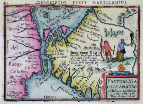
Fretum Magellanicum

| Article ID | AMS0727 |
Title | Fretum Magellanicum |
Description | Map shows the Magellan Street with the south part of America and Tierra del Fuego. |
| Year | ca. 1630 |
Artist | Kaerius (1570-1630) |
Pieter van den Keere, or Petrus Kaerius (1570-1630). He was born in Ghent, and in 1584 moved with his family for religious reasons to London. From his time in England there is a map of Ireland from 1592, Hyberniae novissima descriptio. It was published by Hondius and served as a model for later editions of the Theatrum of Abraham Ortelius. Keere also contributed to John Norden's Speculum Britanniae of 1593. He also worked with Petrus Bertius, Cornelis Claesz, Petrus Plancius, the House of Visscher, and Lucas Janszoon Waghenaer. In 1595, there appeared a large wall map of Europe in 10 sheets, Nova totius Europae descriptio. From 1603, Keere began creating large urban panoramas, including Utrecht, Cologne, Amsterdam, and Paris. Around 1604, he was preparing the publication of the atlas Germania Inferior id est Provincuarum XVII. This first appeared in 1617, with a foreword by Petrus Montanus. | |
Historical Description | Ferdinand Magellan (1480 –1521) was a Portuguese explorer who organised the Spanish expedition to the East Indies from 1519 to 1522, resulting in the first circumnavigation of the Earth, completed by Juan Sebastián Elcano. Born into a Portuguese noble family in around 1480, Magellan became a skilled sailor and naval officer and was eventually selected by King Charles I of Spain to search for a westward route to the Maluku Islands (the "Spice Islands"). Commanding a fleet of five vessels, he headed south through the Atlantic Ocean to Patagonia, passing through the Strait of Magellan into a body of water he named the "peaceful sea" (the modern Pacific Ocean). Despite a series of storms and mutinies, the expedition reached the Spice Islands in 1521 and returned home via the Indian Ocean to complete the first circuit of the globe. Magellan did not complete the entire voyage, as he was killed during the Battle of Mactan in the Philippines in 1521. Tierra del Fuego is an archipelago off the southernmost tip of the South American mainland, across the Strait of Magellan. The archipelago consists of the main island, Isla Grande de Tierra del Fuego. Europeans first explored the islands during Ferdinand Magellan's expedition of 1520; Tierra del Fuego and similar namings stem from sightings of the many bonfires that the natives built. |
| Place of Publication | Amsterdam |
| Dimensions (cm) | 9 x 12,5 |
| Condition | Very good |
| Coloring | original colored |
| Technique | Copper print |