

Adina Sommer
Antique and Contemporary Art
Winzerer Str. 154
80797 München
telephone
+49 89 304714
business hours:
by appointment
Email
![]()


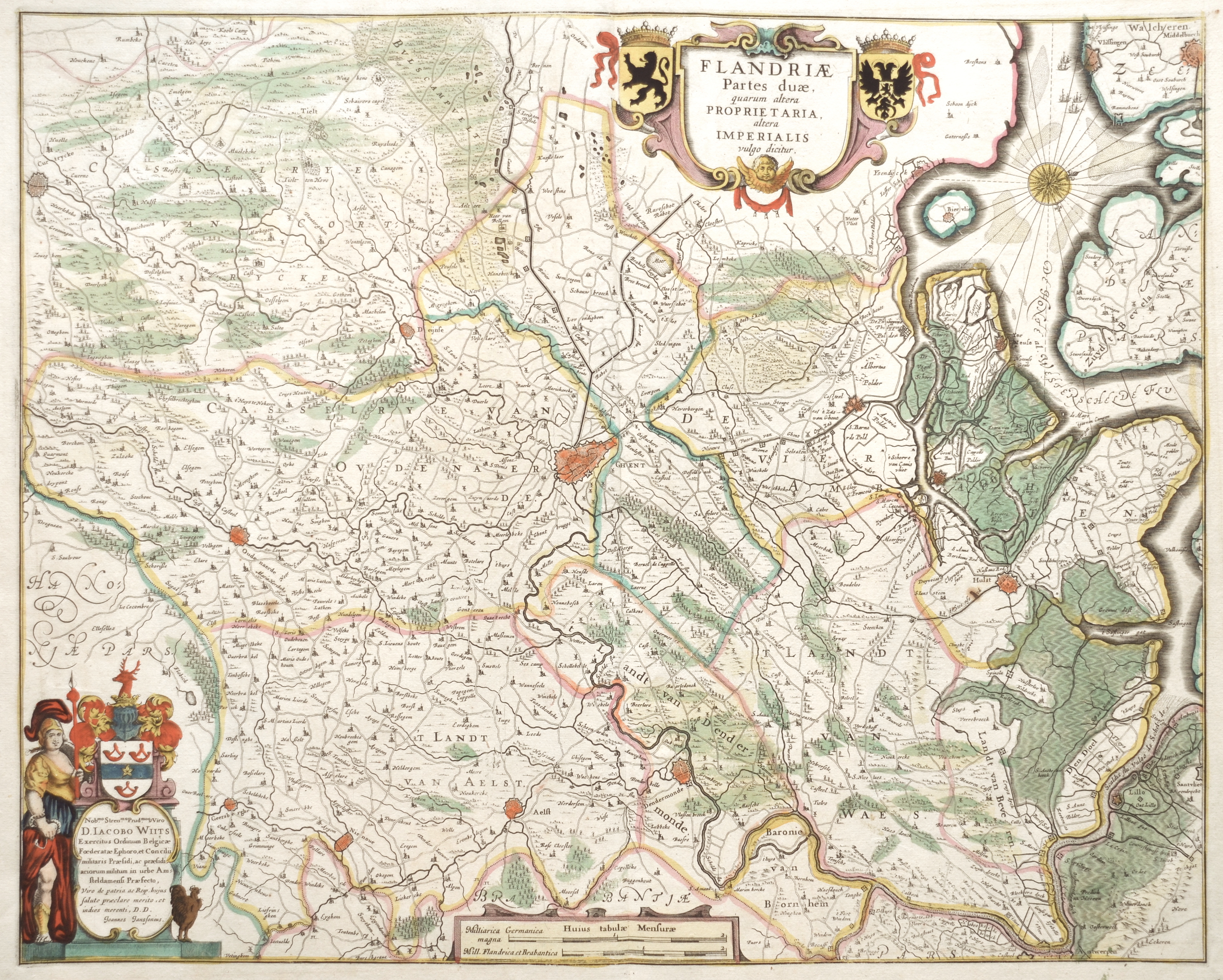
Flandriae Partes duae, quarum altera Proprietaria, altera Imperialis vulgo dicitur,

| Article ID | EUB4105 |
Title | Flandriae Partes duae, quarum altera Proprietaria, altera Imperialis vulgo dicitur, |
Description | Map shows total Flandria ( Belgium) with cartouches with decorative coat of arms. The map is showing the cities of Gent, Aalst, Axel, Hust and others. |
| Year | ca. 1660 |
Artist | Janssonius (1588-1664) |
Johannes Janssonius (Jansson)( 1588- 1664) Amsterdam, was born in Arnhem, the son of Jan Janszoon the Elder, a publisher and bookseller. In 1612 he married Elisabeth de Hondt, the daughter of Jodocus Hondius. He produced his first maps in 1616 of France and Italy. In 1623 Janssonius owned a bookstore in Frankfurt am Main, later also in Danzig, Stockholm, Copenhagen, Berlin, Königsberg, Geneva and Lyon. In the 1630s he formed a partnership with his brother in law Henricus Hondius, and together they published atlases as Mercator/Hondius/Janssonius. Under the leadership of Janssonius the Hondius Atlas was steadily enlarged. Renamed Atlas Novus, it had three volumes in 1638, one fully dedicated to Italy. 1646 a fourth volume came out with ""English County Maps"", a year after a similar issue by Willem Blaeu. Janssonius' maps are similar to those of Blaeu, and he is often accused of copying from his rival, but many of his maps predate those of Blaeu and/or covered different regions. By 1660, at which point the atlas bore the appropriate name ""Atlas Major"", there were 11 volumes, containing the work of about a hundred credited authors and engravers. It included a description of ""most of the cities of the world"" (Townatlas), of the waterworld (Atlas Maritimus in 33 maps), and of the Ancient World (60 maps). The eleventh volume was the Atlas of the Heavens by Andreas Cellarius. Editions were printed in Dutch, Latin, French, and a few times in German. | |
Historical Description | As the province of Belgica - a name introduced by Caesar - what is now Belgium experienced many rulers. From the High Middle Ages to the early modern period, the cities of Flanders with their cloth industries represented one of the two centers of the European economy. Politically, the individual territories came under the House of Burgundy, which was inherited by the Habsburgs in 1477. In 1579 the Catholic Union of Arras and the Calvinist-Protestant Union of Utrecht were formed. The provinces of the Union of Utrecht broke away from Spain in 1581 and founded the Republic of the Seven United Provinces, whose independence was recognized in the Peace of Westphalia of 1648 after the end of the Eighty Years War. The provinces of the Union of Arras, Flanders and Brabant were administered as the Spanish Netherlands by a Spanish governor. After the extinction of the Spanish Habsburgs (1700) and the resulting War of the Spanish Succession, the Austrian Netherlands came under the rule of the Austrian Habsburgs in 1714. As a result of the absolutist-centralistic efforts of the Austrian ruler Joseph II, the Brabant Revolution came in 1789 and the short-lived United Belgian States. Revolutionary France annexed the Austrian Netherlands between 1792 and 1794, followed by incorporation into the French Republic in 1795. At the Congress of Vienna (1815) the provinces were awarded to the Netherlands. After the Belgian Revolution, the country gained independence in 1830. |
| Place of Publication | Amsterdam |
| Dimensions (cm) | 41 x 51,5 cm |
| Condition | Some folds |
| Coloring | original colored |
| Technique | Copper print |