

Adina Sommer
Antique and Contemporary Art
Winzerer Str. 154
80797 München
telephone
+49 89 304714
business hours:
by appointment
Email
![]()


Europae
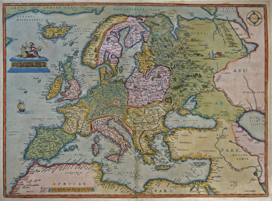

| Article ID | EUX1690 |
Title | Europae |
Description | Map shows total Europe with all countries and its borders and a titel cartouche. |
| Year | ca. 1590 |
Artist | Ortelius (1527-1598) |
Abraham Ortelius (1527–1598) was a Flemish cartographer and publisher from Antwerp. Originally a map colorist, he became a major figure in cartography through his Theatrum Orbis Terrarum (1570), considered the first modern atlas—a uniform collection of reliable maps in book form. Influenced by Gerardus Mercator, Ortelius published several maps before compiling the Theatrum, which clearly showed America as a separate continent. The work was published in 42 editions and 7 languages by 1612. Unlike many of his peers, Ortelius cited his sources, and his atlas became a milestone in mapmaking and geographic knowledge. | |
Historical Description | The history of Europe from the 15th to the 19th century was shaped by profound political, social, and cultural changes that formed modern Europe. At the beginning of the 15th century, Europe was marked by the effects of the Middle Ages and the feudal structure. A significant event was the Renaissance, which began around 1400 in Italy and marked a revival of classical ancient culture, art, and sciences. The invention of the printing press by Johannes Gutenberg around 1440 was also revolutionary and promoted the spread of knowledge. By the end of the century, European explorers, such as Christopher Columbus, began finding new trade routes, which led to the discovery of the New World. The 16th century was defined by the Reformation, when Martin Luther published his 95 Theses in 1517, challenging the Catholic Church. This led to religious conflicts and the division of Western Christianity into Catholics and Protestants. Politically, Europe saw the rise of the Habsburg Empire and the development of nation-states such as France and England. The age of exploration continued, leading to a new wave of colonization. The 17th century was a time of wars and political instability, including the Thirty Years' War (1618–1648), which devastated much of Europe. These conflicts resulted in significant territorial changes and the establishment of the modern Treaty of Westphalia in 1648. During this time, Absolutism took root, with monarchs like Louis XIV of France exercising absolute power. The 18th century was marked by the ideas of the Enlightenment, which emphasized reason, science, and individual freedom. This led to profound political and social reforms. At the same time, major wars such as the War of Spanish Succession (1701–1714) and the Seven Years' War (1756–1763) took place. The century ended with the events of the French Revolution (1789), which overthrew the monarchy and established the Republic. This paved the way for the Napoleonic Wars and the Napoleonic Era, which triggered political and social upheavals throughout Europe. The 19th century was shaped by the aftermath of the French Revolution and the Napoleonic Wars, which reshaped Europe's political system. After Napoleon's defeat in 1815, Europe was reorganized at the Congress of Vienna. Nationalism and Liberalism grew, leading to significant political upheavals, including the German Confederation, the unification of Italy, and the formation of the German Empire in 1871. At the same time, industrialization and urbanization began, significantly altering Europe's economic and social structure. The 19th century ended with the outbreak of World War I in 1914, which shattered the entire European power structure and many social systems. |
| Place of Publication | Antwerp |
| Dimensions (cm) | 34,5 x 46 |
| Condition | Missing part at center perfectly replaced, mounted |
| Coloring | original colored |
| Technique | Copper print |