

Adina Sommer
Antique and Contemporary Art
Winzerer Str. 154
80797 München
telephone
+49 89 304714
business hours:
by appointment
Email
![]()


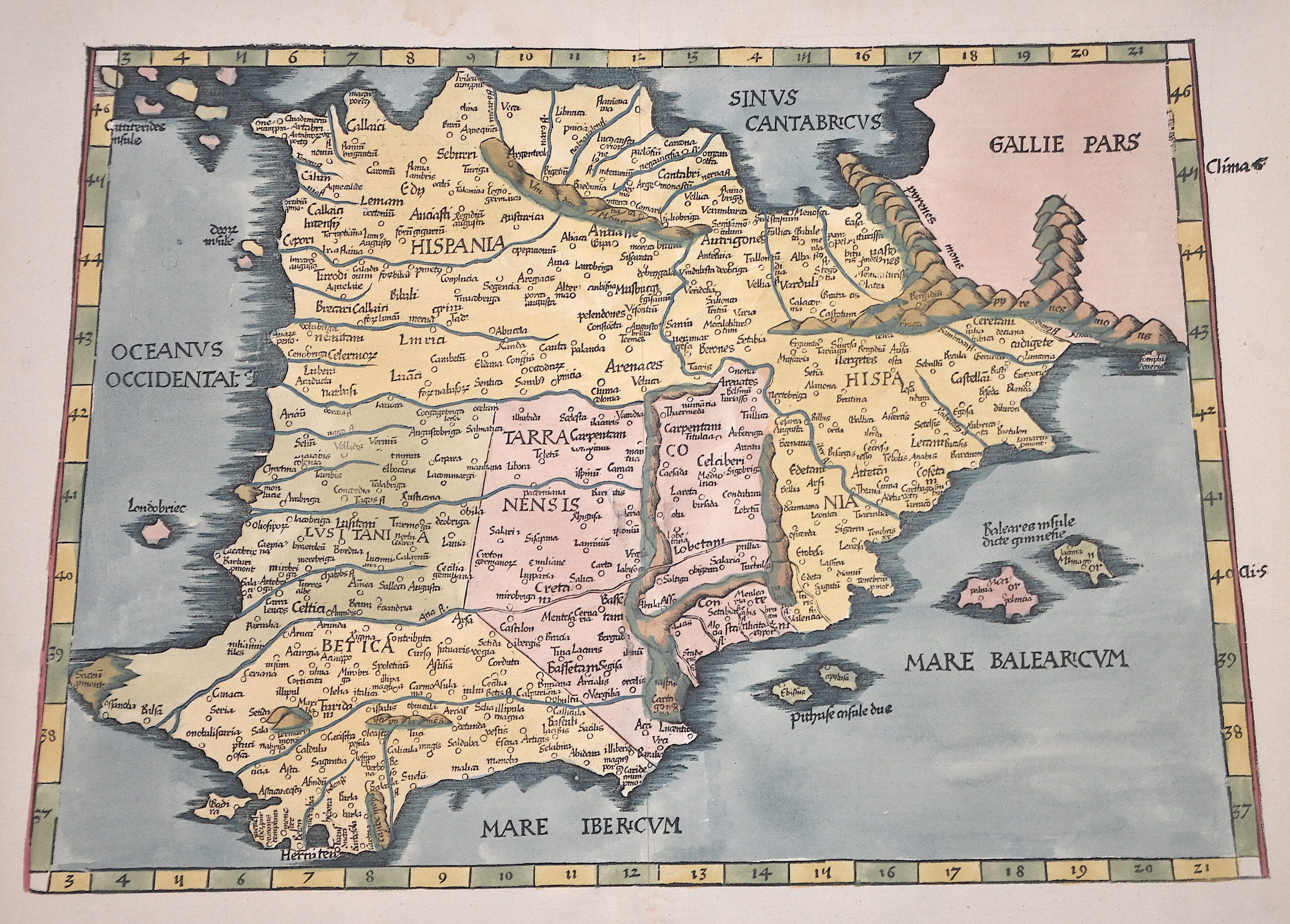
Europae tabula secunda continet Hispaniam…

| Article ID | EUE1319 |
Title | Europae tabula secunda continet Hispaniam… |
Description | Map shows in trapezoidal form the Iberian Peninsula with Spain, Portugal and the Balearic Islands (Mallorca, Menorca, Ibiza). From the atlas "Geographie opus novissima traductione e gricorum archetypis". |
| Year | ca. 1513 |
Artist | Ptolemy/Waldseemüller- Johann Schott (1477-1550) |
Johann Schott (1477–1550) reissued Martin Waldseemüller’s maps, including 20 detailed regional maps in his atlas Tabula Moderna Germanie, making it one of the most important works of its time. Schott is also known for the atlases Alexandri Magni and Margarita philosophica. Martin Waldseemüller (born c. 1470s, Radolfzell, Germany) studied at Freiburg University and later moved to Lorraine, France, where he joined the intellectual circle Gymnasium Vosagense. He died in 1522. Waldseemüller created the 1507 wall map that first named America and completed maps for a 1513 edition of Ptolemy’s Geography. His atlas merged cartographic science with printing art and included 20 modern maps alongside Ptolemaic ones, using a new quadratic projection. Johannes Schott printed the atlas, with Waldseemüller providing the drawings. Editors Jacobus Äschler and George Uebel worked on the text. Supported by René, Duke of Lorraine, Waldseemüller developed new maps abandoning Ptolemy’s projection for rectilinear meridians and parallels. Due to the Duke’s death, printing was delayed until 1512. The atlas included 26 classical Ptolemaic maps plus 20 new ones published separately. The New World map was based on recent, reliable information attributed to “The Admiral,” believed to be Columbus, leading to the atlas being called the Admiral Atlas. Schott printed a version with minor corrections in Augsburg. Ptolemy’s Geographia (c. 100–160 AD) listed geographic coordinates for nearly 10,000 locations across Africa, Asia, and Europe, organized into regions—an early concept of an atlas. Research on this work, notably at the University of Thessaloniki, continues today. Most maps bear a watermark of a triple-pointed crown. | |
Historical Description | In prehistoric and prehistoric times, Iberians, Celts and Basques settled on the Iberian peninsula named after the former. In the 11th century BC The Phoenicians settled on the south coast; the most famous of their colonies was Cadiz. The name Spain is derived from the Roman name Hispania (from Phoenician ishapan "land of the rock hyrax". In the early 8th century, the Moors destroyed the Visigoth Empire and conquered the entire Iberian Peninsula. Their centuries of rule shaped the country. The Arabic heritage was reflected in both the architecture and the language. However, the Moors were unable to establish themselves permanently in the northern outskirts of the peninsula. From there the "Reconquest" (Reconquista) started. In this process, which spanned several centuries (722–1492) and was not continuous, the Muslim empires were gradually pushed back by the Christian empires until the fall of Granada in 1492, the last Moorish state structure on the peninsula also disappeared. In the 15th century, the kingdoms of Castile and Aragon were united. Aragon was an important maritime power in the Mediterranean at that time. The Spanish colonial empire extended around 1600 across large parts of South and Central America, the southern part of today's USA and the Philippines. As the English and French also intensified their colonial efforts, Spain gradually lost its supremacy. The liberation wars of the American states, particularly the Mexican and South American wars of independence in the early 19th century, brought independence to most of the colonies. In 1898, the last major properties were lost to the United States during the Spanish-American War, which meant the end of the colonial empire. The African colonies that followed later (Spanish-Morocco, Spanish-Sahara and Equatorial Guinea) finally became independent in the 20th century. |
| Place of Publication | Strassburg |
| Dimensions (cm) | 31 x 45,5 |
| Condition | Perfect condition |
| Coloring | original colored |
| Technique | Copper print |