

Adina Sommer
Antique and Contemporary Art
Winzerer Str. 154
80797 München
telephone
+49 89 304714
business hours:
by appointment
Email
![]()


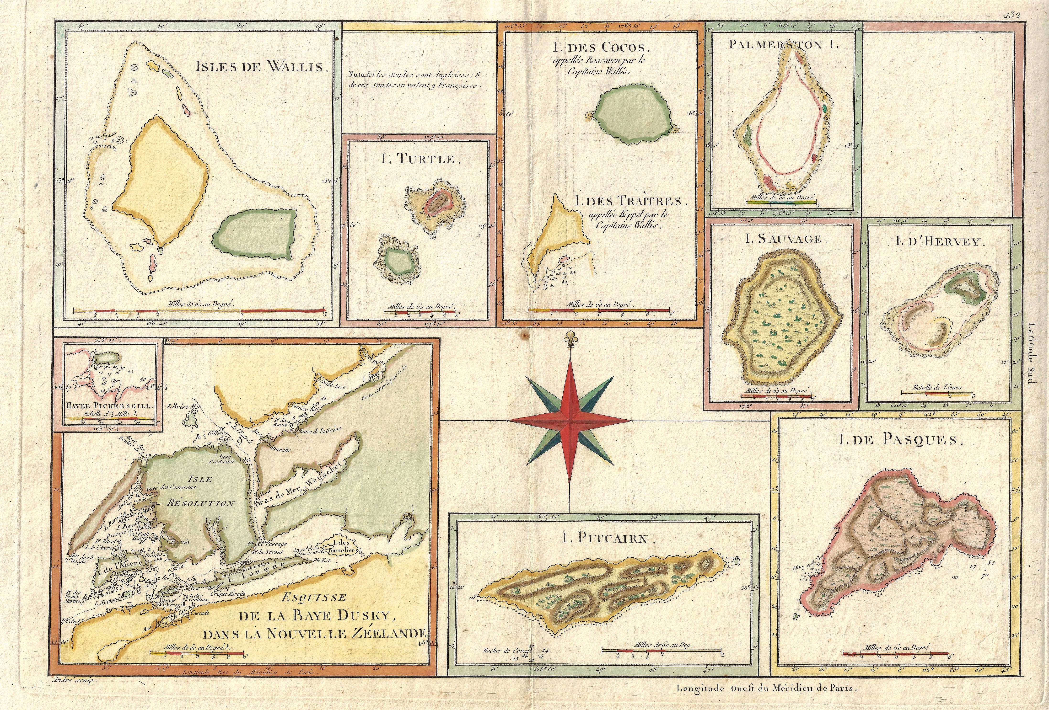
Esquisse de la Baye Dusky, dans la Nouvelle Zéelande.

| Article ID | OZ0415 |
Title | Esquisse de la Baye Dusky, dans la Nouvelle Zéelande. |
Description | Ten maps and a compass rose on one sheet. They show Dusky Sound (a fjord in New Zealand), Pitcairn in the Pacific, Wallis in the Southern Pacific (between Fiji and Samoa), I. des Cocos in Southeast Asia, I. de Pasques (Easter Islands), etc. |
| Year | ca. 1787 |
Artist | Bonne (1727-1795) |
Rigobert Bonne (1727–1795) was one of the most important cartographers of the late 18th century. In 1773 Bonne succeeded Jacques Nicolas Bellin as Royal Cartographer to France in the office of the Hydrographer at the Depôt de la Marine. Working in his official capacity, Bonne compiled some of the most detailed and accurate maps of the period. Bonne’s work represents an important step in the evolution of the cartographic ideology away from the decorative work of the 17th and early 18th century towards a more detail oriented and practical aesthetic. With regard to the rendering of terrain Bonne maps bear many stylistic similarities to those of his predecessor, Bellin. However, Bonne maps generally abandon such common 18th century decorative features such as hand coloring, elaborate decorative cartouches, and compass roses. While mostly focusing on coastal regions, the work of Bonne is highly regarded for its detail, historical importance, and overall aesthetic appeal. | |
Historical Description | New Zealand was discovered by Polynesians around the end of the 13th century, or at the latest in the first half of the 14th century, and was settled in several waves of immigration. The descendants of the first immigrants founded the Māori culture. The first Māori to reach the land found no mammals. To feed themselves, they first hunted the moa, a flightless bird remotely similar to the African ostrich. The first European to set eyes on New Zealand was the Dutch navigator Abel Tasman. His mission was to find the "Great Southern Land" because valuable raw materials were suspected there. On his voyage, in 1642, he discovered a "great high land" on the South Island, today's West Coast region. He was not sure and suspected that he had discovered another piece of Staten Landt coast. When he went to Golden Bay in what is now the Tasman region to explore the land up close, he had his first bloody encounter with the "aborigines" in which four Dutch sailors were killed. The "discoverer of New Zealand" never set foot on New Zealand soil. A year later, when an expedition under Hendrik Brouwer determined that the coastal strip found by Tasman did not belong to Staten Landt, the country was named Nova Zeelandia (Latin) or Nieuw Zeeland (Dutch), in reference to Australia, which had been called Nova Hollandia or Nieuw Holland. Like Tasman, the British captain James Cook was to find a suspected southern continent. In 1769, Cook's ship Endeavour, coming from Tahiti, encountered New Zealand at the southwestern point of the bay called Poverty Bay. After first hostile encounters, but then also successful approaches with Māori, Cook first circumnavigated the North Island and, after a longer stay in the Marlborough Sounds, the South Island and was thus able to prove that New Zealand was islands and not part of a continent. Cook and the scientists accompanying him began to map the country thoroughly, they explored flora and fauna extensively and gathered information about the Māori. Only a few weeks after Cook, Jean François Marie de Surville also reached the islands. In the following years, mainly whalers, sealers and later missionaries migrated to New Zealand. These maintained pronounced contacts with the Māori. The two parties engaged in lively trade with each other, and some Europeans also lived together with the Māori. |
| Place of Publication | Paris |
| Dimensions (cm) | 23,5 x 34,5 cm |
| Condition | Perfect condition |
| Coloring | colored |
| Technique | Copper print |