

Adina Sommer
Antique and Contemporary Art
Winzerer Str. 154
80797 München
telephone
+49 89 304714
business hours:
by appointment
Email
![]()


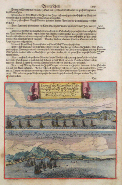
Entwurff der Nassanischen Flotta, wie dieselbe ahn dem Ufer New Hispanien gelegen, und auff die Schiffe von Manila kommend gewart hat

| Article ID | AMZ0688 |
Title | Entwurff der Nassanischen Flotta, wie dieselbe ahn dem Ufer New Hispanien gelegen, und auff die Schiffe von Manila kommend gewart hat |
Description | Map shows the coast of Accapulco( Map shows the coast of the island Guagan in the Pacific ocean. Theodor De Bry’s Grand Voyages, an illustrated collection of accounts of the Americas, defined the early European picture of the New World. |
| Year | ca. 1630 |
Artist | Bry, de - Merian (1528-1598) |
In 1631, Matthäus Merian and Johann Ludwig Gottfried published Historia Antipodum, a heavily abridged, single-volume version of Theodor De Bry’s 14-part America series. After De Bry’s death, his sons continued the project. Merian, a skilled engraver, later married De Bry’s daughter and collaborated with Gottfried. The Historia Antipodum reorganized numerous travel accounts into three chapters covering nature, exploration, and recent colonial developments. Merian and Gottfried significantly reworked the content, merging reports and integrating illustrations into the text. Their depiction of the natural world and Indigenous cultures—drawing in part on José de Acosta’s writings—was particularly influential. The book stands as one of the most ambitious works of early modern travel literature. | |
Historical Description | The Spanish first learned of Mexico during the Juan de Grijalva expedition of 1518. The Spanish conquest of the Aztec Empire began in February 1519 when Hernán Cortés arrived at the port in Veracruz with ca. 500 conquistadores. After taking control of that city, he moved on to the Aztec capital. In his search for gold and other riches, Cortés decided to invade and conquer the Aztec empire. When the Spaniards arrived, the ruler of the Aztec empire was Moctezuma II, who was later killed. His successor and brother Cuitláhuac took control of the Aztec empire, but was among the first to fall from the first smallpox epidemic in the area a short time later. The capture of Tenochtitlan and refounding of Mexico City in 1521 was the beginning of a 300-year-long colonial era during which Mexico was known as Nueva España (New Spain). The Kingdom of New Spain was created from the remnants of the Aztec hegemonic empire. Subsequent enlargements, such as the conquest of the Tarascan state, resulted in the creation of the Viceroyalty of New Spain in 1535. The Viceroyalty at its greatest extent included the territories of modern Mexico, Central America as far south as Costa Rica, and the western United States. The Viceregal capital Mexico City also administrated the Spanish West Indies (the Caribbean), the Spanish East Indies (the Philippines), and Spanish Florida. |
| Place of Publication | Frankfurt on Main |
| Dimensions (cm) | 28 x 17,5 cm |
| Condition | Very good |
| Coloring | original colored |
| Technique | Copper print |