

Adina Sommer
Antique and Contemporary Art
Winzerer Str. 154
80797 München
telephone
+49 89 304714
business hours:
by appointment
Email
![]()


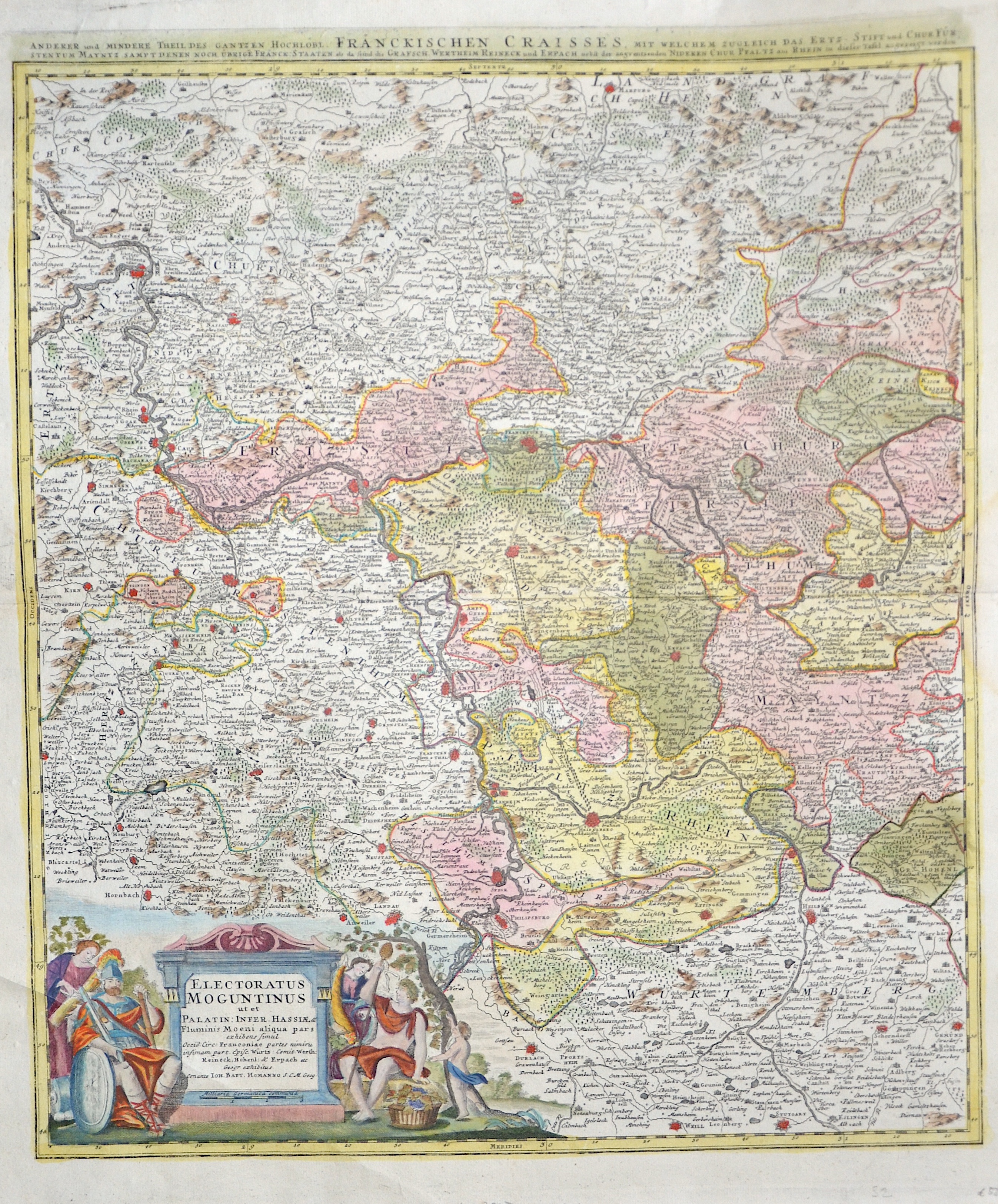
Electoratus Moguntinus ut et Palatin: Infer. Hassiae, & /Anderer und mindere Theil des gantzen hochlöbl. Fränckischen Craisses,..

| Article ID | EUD4356 |
Title | Electoratus Moguntinus ut et Palatin: Infer. Hassiae, & /Anderer und mindere Theil des gantzen hochlöbl. Fränckischen Craisses,.. |
Description | Map shows the course of the Rhine from Koblenz to Speyer with the cities of Mainz (in Rhineland-Palatinate), Darmstadt (in Hesse), Heidelberg and Wertheim (in Baden-Württemberg) and a title cartouche. |
| Year | ca. 1710 |
Artist | Homann (1664-1724) |
Johann Babtiste Homann (1664-1724), Nuremberg, was born in Oberkammlach, the Electorate of Bavaria. Although educated at a Jesuit school, and preparing for an ecclesiastical career, he eventually converted to Protestantism and from 1687 worked as a civil law notary in Nuremberg. He soon turned to engraving and cartography; in 1702 he founded his own publishing house. Homann acquired renown as a leading German cartographer, and in 1715 was appointed Imperial Geographer by Emperor Charles VI. Giving such privileges to individuals was an added right that the Holy Roman Emperor enjoyed. In the same year he was also named a member of the Prussian Academy of Sciences in Berlin. Of particular significance to cartography were the imperial printing privileges (Latin: privilegia impressoria). These protected for a time the authors in all scientific fields such as printers, copper engravers, map makers and publishers. They were also very important as a recommendation for potential customers. In 1716 Homann published his masterpiece Grosser Atlas ueber die ganze Welt (Grand Atlas of all the World). Numerous maps were drawn up in cooperation with the engraver Christoph Weigel the Elder, who also published Siebmachers Wappenbuch. Homann died in Nuremberg. He was succeeded by the Homann heirs company, which was in business until 1848. The company was known as Homann Erben, Homanniani Heredes, or Heritiers de Homann abroad. | |
Historical Description | Rhineland-Palatinate is surrounded by the states of North Rhine-Westphalia, Saarland, Baden-Württemberg and Hesse. It also borders three foreign countries: France, Luxembourg and Belgium. Rhineland-Palatinate was established in 1946 after World War II, from territory of the historically separate regions of the Free State of Prussia, the People's State of Hesse and Bavaria, by the French military administration in Allied-occupied Germany. Rhineland-Palatinate became part of the Federal Republic of Germany in 1949 and shared the country's only border with the Saar Protectorate until it was returned to German control in 1957. Rhineland-Palatinate has since developed its own identity built on its natural and cultural heritage, including the extensive Palatinate winegrowing region, its picturesque landscapes, and its many castles and palaces. |
| Place of Publication | Nuremberg |
| Dimensions (cm) | 56,5 x 48 cm |
| Condition | Perfect condition |
| Coloring | original colored |
| Technique | Copper print |