

Adina Sommer
Antique and Contemporary Art
Winzerer Str. 154
80797 München
telephone
+49 89 304714
business hours:
by appointment
Email
![]()


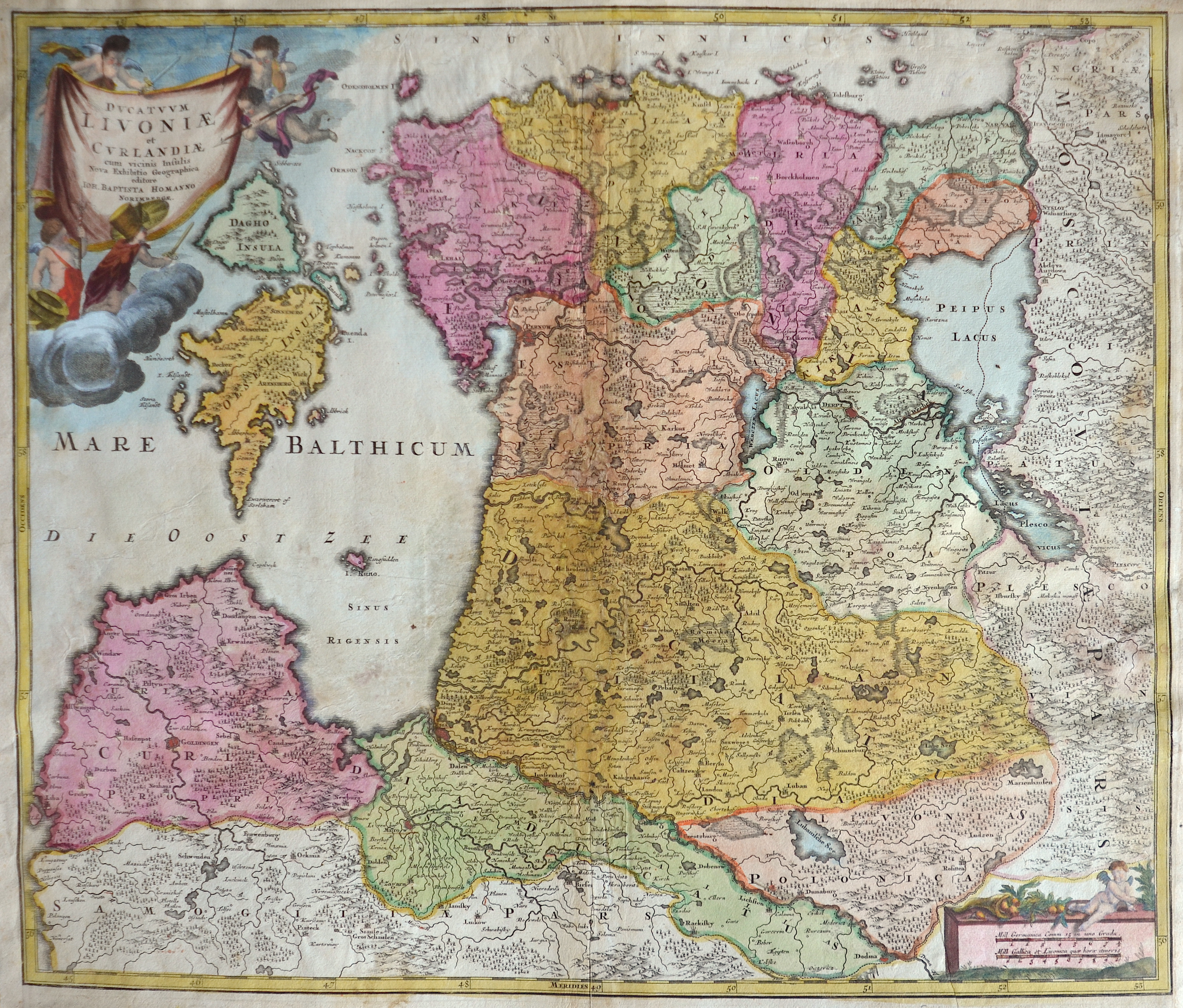
Ducatuum Livoniae et Curlandiae cum vicinis Insulis Nova Exhibitio Geographica editore..

| Article ID | EUL4167 |
Title | Ducatuum Livoniae et Curlandiae cum vicinis Insulis Nova Exhibitio Geographica editore.. |
Description | Map depicts Estland and the city Reval (Tallin), Pernau with Lettland and the city Riga, Kuldiga, Jelgava and two decorative cartouches. |
| Year | ca. 1710 |
Artist | Homann (1664-1724) |
Johann Babtiste Homann (1664-1724), Nuremberg, was born in Oberkammlach, the Electorate of Bavaria. Although educated at a Jesuit school, and preparing for an ecclesiastical career, he eventually converted to Protestantism and from 1687 worked as a civil law notary in Nuremberg. He soon turned to engraving and cartography; in 1702 he founded his own publishing house. Homann acquired renown as a leading German cartographer, and in 1715 was appointed Imperial Geographer by Emperor Charles VI. Giving such privileges to individuals was an added right that the Holy Roman Emperor enjoyed. In the same year he was also named a member of the Prussian Academy of Sciences in Berlin. Of particular significance to cartography were the imperial printing privileges (Latin: privilegia impressoria). These protected for a time the authors in all scientific fields such as printers, copper engravers, map makers and publishers. They were also very important as a recommendation for potential customers. In 1716 Homann published his masterpiece Grosser Atlas ueber die ganze Welt (Grand Atlas of all the World). Numerous maps were drawn up in cooperation with the engraver Christoph Weigel the Elder, who also published Siebmachers Wappenbuch. Homann died in Nuremberg. He was succeeded by the Homann heirs company, which was in business until 1848. The company was known as Homann Erben, Homanniani Heredes, or Heritiers de Homann abroad. | |
Historical Description | The Baltic States (Latin Balticum) is an area in Europe, which today includes the countries of Estonia, Latvia and Lithuania. The Baltic is named after the Central Latin name for the Baltic Sea as mare balticum, the "Baltic Sea". This term had been in use since the 11th century and first appeared with Adam von Bremen. The use of „mare balticum“ can be traced back to the name of a large island with rich amber deposits in northern Europe, which the ancient Roman scholar Pliny the Elder mentioned as Baltia or Balcia, actually probably Abalcia, and which was identified with the Prussian coast in the Middle Ages . The commercial cities were able to secure far-reaching freedoms within the order and achieved great wealth, especially in the 15th century, when they dominated the Baltic Sea trade as members of the Hanseatic League. The Baltic port cities were therefore culturally strongly influenced by Germany, Denmark and Sweden and have preserved this legacy in many aspects to this day. The reign of the Order over the territory of what is now Estonia and Latvia (Old Livonia) ended in the mid-16th century during the Reformation. In the Livonian War, Russia failed to conquer Livonia, but the contested territory came under the rule of its opponents, whom Livonia called for help. Livonia and Courland came under Polish sovereignty, Estonia became Swedish and the island of Saaremaa / Øsel Danish. Lithuania remained independent as it established a first alliance and treaty union with Poland, the Union of Krewo, in 1385, the others followed, and in 1569 led to the establishment of the noble republic of the Kingdom of Poland and the Grand Duchy of Lithuania. |
| Place of Publication | Nuremberg |
| Dimensions (cm) | 48,5 x 57 cm |
| Condition | Left, right and upper margin perfectly replaced, Centerfold, some missing parts perfectly restored |
| Coloring | original colored |
| Technique | Copper print |