

Adina Sommer
Antique and Contemporary Art
Winzerer Str. 154
80797 München
telephone
+49 89 304714
business hours:
by appointment
Email
![]()


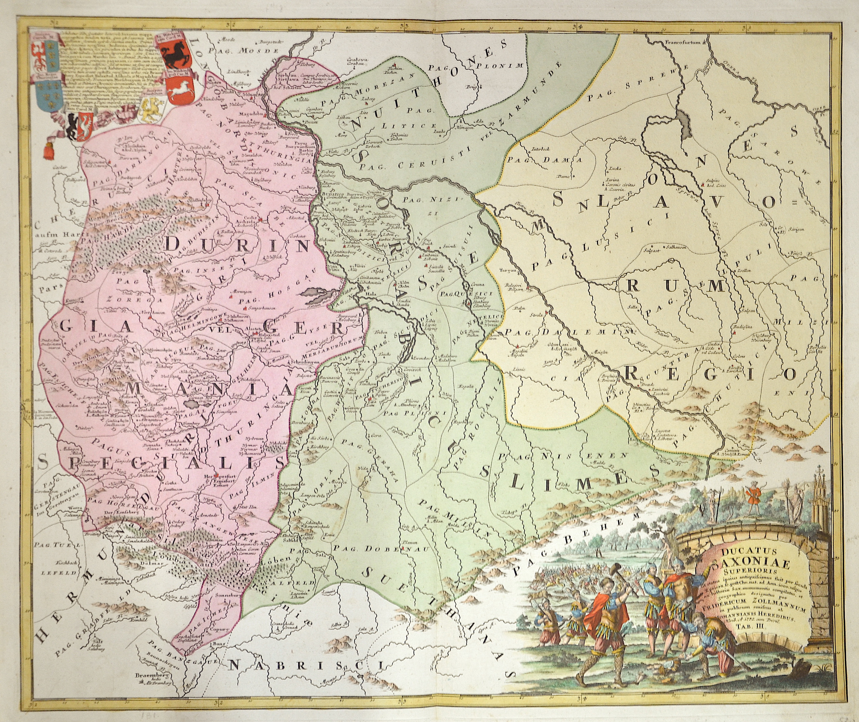
Ducatus Saxoniae Superioris ut status ipsius antiquissimus suit per Secula X. priora, sc. post Chr. nat. ad Ann. iooo..

| Article ID | EUD4677 |
Title | Ducatus Saxoniae Superioris ut status ipsius antiquissimus suit per Secula X. priora, sc. post Chr. nat. ad Ann. iooo.. |
Description | Historical map shows Saxony with Plauen, Eilenburg etc., Saxony-Anhalt with for example Quedlingburg and Thuringia with Erfurt. Cartographer Friedrich Zollmann (1690-1762) shows the dominions mainly in Upper Saxony between the 11th and the 15th century. Upper cartouche with 6 coats of arms of Inaigne Caroli M., Ina. Regni. Thuringiae, In. Witekindr. ante Carol. M. Ins Witekindi post Car. M. Below a title cartouche with warriors and four Slavic god statues: Svantovit (God of War), Flin's God of Pebbles or also known as the Forest God, Radagast (Svarožić, Sun God and Giver of Life), Zernibog (Czorneboh, Black God). |
| Year | c. 1732 |
Artist | Homann Erben |
Johann Babtiste Homann (1664-1724) was born in Oberkammlach, the Electorate of Bavaria. Although educated at a Jesuit school, and preparing for an ecclesiastical career, he eventually converted to Protestantism and from 1687 worked as a civil law notary in Nuremberg. He soon turned to engraving and cartography; in 1702 he founded his own publishing house. Homann acquired renown as a leading German cartographer, and in 1715 was appointed Imperial Geographer by Emperor Charles VI. Giving such privileges to individuals was an added right that the Holy Roman Emperor enjoyed. In the same year he was also named a member of the Prussian Academy of Sciences in Berlin. Of particular significance to cartography were the imperial printing privileges (Latin: privilegia impressoria). These protected for a time the authors in all scientific fields such as printers, copper engravers, map makers and publishers. They were also very important as a recommendation for potential customers. In 1716 Homann published his masterpiece Grosser Atlas ueber die ganze Welt (Grand Atlas of all the World). Numerous maps were drawn up in cooperation with the engraver Christoph Weigel the Elder, who also published Siebmachers Wappenbuch. Homann died in Nuremberg. He was succeeded by the Homann heirs company, which was in business until 1848. The company was known as Homann Erben, Homanniani Heredes, or Heritiers de Homann abroad. | |
Historical Description | Saxony-Wittenberg, in modern Saxony-Anhalt, became subject to the margravate of Meissen, ruled by the Wettin dynasty in 1423. This established a new and powerful state, occupying large portions of the present Free State of Saxony, Thuringia, Saxony-Anhalt and Bavaria (Coburg and its environs). Although the centre of this state was far to the southeast of the former Saxony, it came to be referred to as Upper Saxony and then simply Saxony, while the former Saxon territories were now known as Lower Saxony. In 1485, Saxony was split. A collateral line of the Wettin princes received what later became Thuringia and founded several small states there (see Ernestine duchies). The remaining Saxon state became still more powerful and was known in the 18th century for its cultural achievements, although it was politically weaker than Prussia and Austria, states which oppressed Saxony from the north and south, respectively. |
| Place of Publication | Nuremberg |
| Dimensions (cm) | 49 x 58 cm |
| Condition | Perfect condition |
| Coloring | original colored |
| Technique | Copper print |