

Adina Sommer
Antique and Contemporary Art
Winzerer Str. 154
80797 München
telephone
+49 89 304714
business hours:
by appointment
Email
![]()


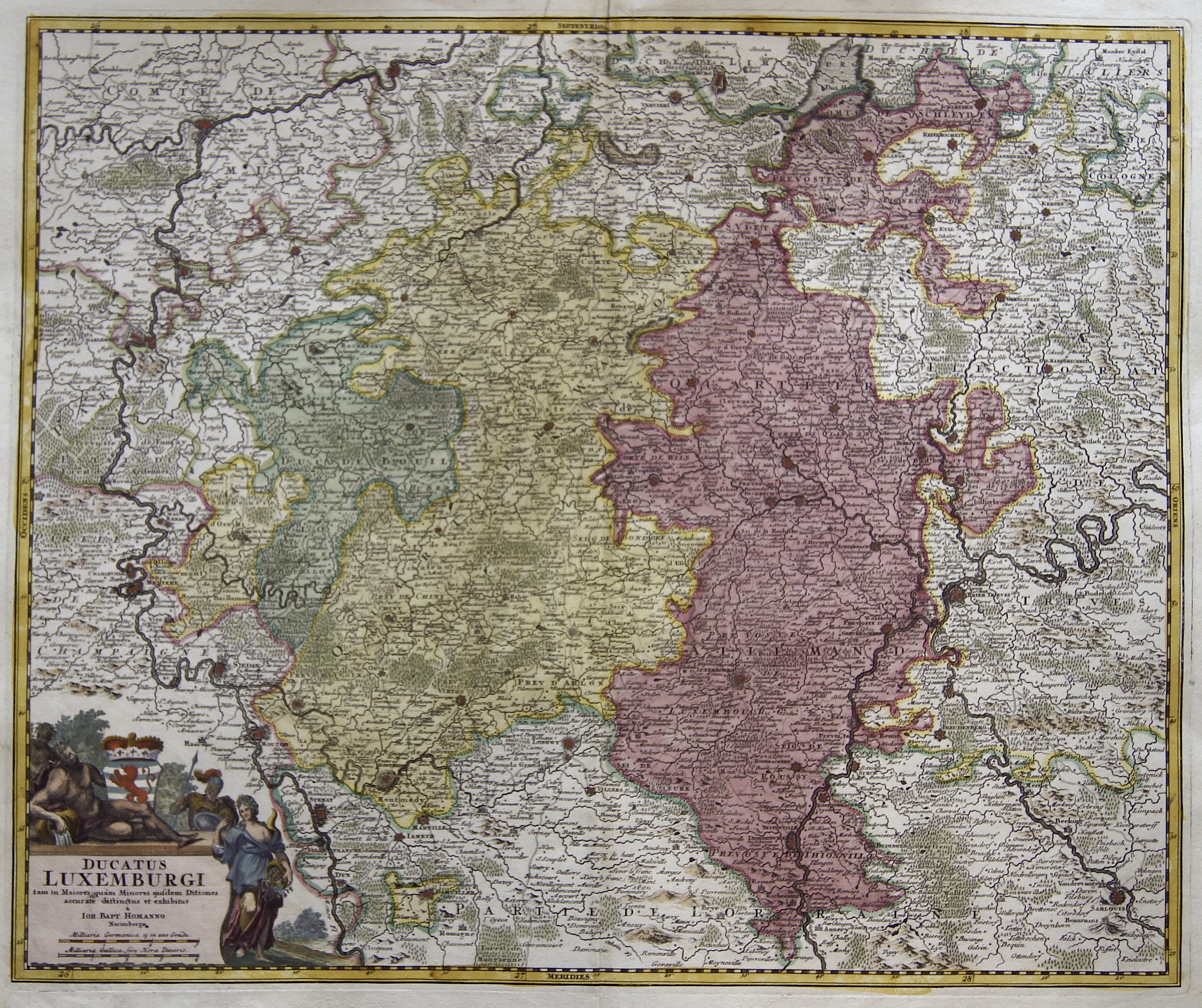
Ducatus Luxemburgi tam in Maiores quam Minores ejusdem Ditiones …

| Article ID | EUB3773 |
Title | Ducatus Luxemburgi tam in Maiores quam Minores ejusdem Ditiones … |
Description | Map shows the whole of Luxembourg, with the Walloon region (cities: Virton, Bastogne, Saint-Hubert, etc.) and partly Belgium with the province of Luxembourg in Belgium. Furthermore, a title cartouche with the coat of arms of Luxembourg. |
| Year | ca. 1710 |
Artist | Homann (1664-1724) |
Johann Babtiste Homann (1664-1724), Nuremberg, was born in Oberkammlach, the Electorate of Bavaria. Although educated at a Jesuit school, and preparing for an ecclesiastical career, he eventually converted to Protestantism and from 1687 worked as a civil law notary in Nuremberg. He soon turned to engraving and cartography; in 1702 he founded his own publishing house. Homann acquired renown as a leading German cartographer, and in 1715 was appointed Imperial Geographer by Emperor Charles VI. Giving such privileges to individuals was an added right that the Holy Roman Emperor enjoyed. In the same year he was also named a member of the Prussian Academy of Sciences in Berlin. Of particular significance to cartography were the imperial printing privileges (Latin: privilegia impressoria). These protected for a time the authors in all scientific fields such as printers, copper engravers, map makers and publishers. They were also very important as a recommendation for potential customers. In 1716 Homann published his masterpiece Grosser Atlas ueber die ganze Welt (Grand Atlas of all the World). Numerous maps were drawn up in cooperation with the engraver Christoph Weigel the Elder, who also published Siebmachers Wappenbuch. Homann died in Nuremberg. He was succeeded by the Homann heirs company, which was in business until 1848. The company was known as Homann Erben, Homanniani Heredes, or Heritiers de Homann abroad. | |
Historical Description | Luxembourg has undergone a remarkable development throughout its history. From a small county in the Middle Ages to a strategically important area during the major wars of Europe, and eventually to a modern, prosperous country within the European Union, Luxembourg has established itself as an independent and stable state. The early history of Luxembourg was strongly shaped by Roman and later Frankish rule. During the Roman period, the area was part of the empire, and in the Middle Ages, it belonged to the Frankish kingdoms. In 1354, the Holy Roman Emperor Charles IV elevated Luxembourg to a duchy, making it an important territorial possession in the Holy Roman Empire. In the 16th century, Luxembourg came under the control of the Habsburgs, who held both the Spanish and Austrian inheritances. Under Spanish rule, Luxembourg was used as a strategic point in the wars between Spain and the Netherlands. In 1795, during the French Revolution, Luxembourg was conquered by the French and incorporated into the French Empire. In 1839, after the Belgian Revolution, Luxembourg was divided between Belgium and the Kingdom of the Netherlands. The western part of the country fell to Belgium, while the eastern part remained with the Netherlands. This division shaped Luxembourg's modern geographical boundaries and gave it its current form. Today, Luxembourg is a constitutional monarchy and one of the wealthiest countries in the world. |
| Place of Publication | Nuremberg |
| Dimensions (cm) | 48 x 58 cm |
| Condition | Perfect condition |
| Coloring | original colored |
| Technique | Copper print |