

Adina Sommer
Antique and Contemporary Art
Winzerer Str. 154
80797 München
telephone
+49 89 304714
business hours:
by appointment
Email
![]()


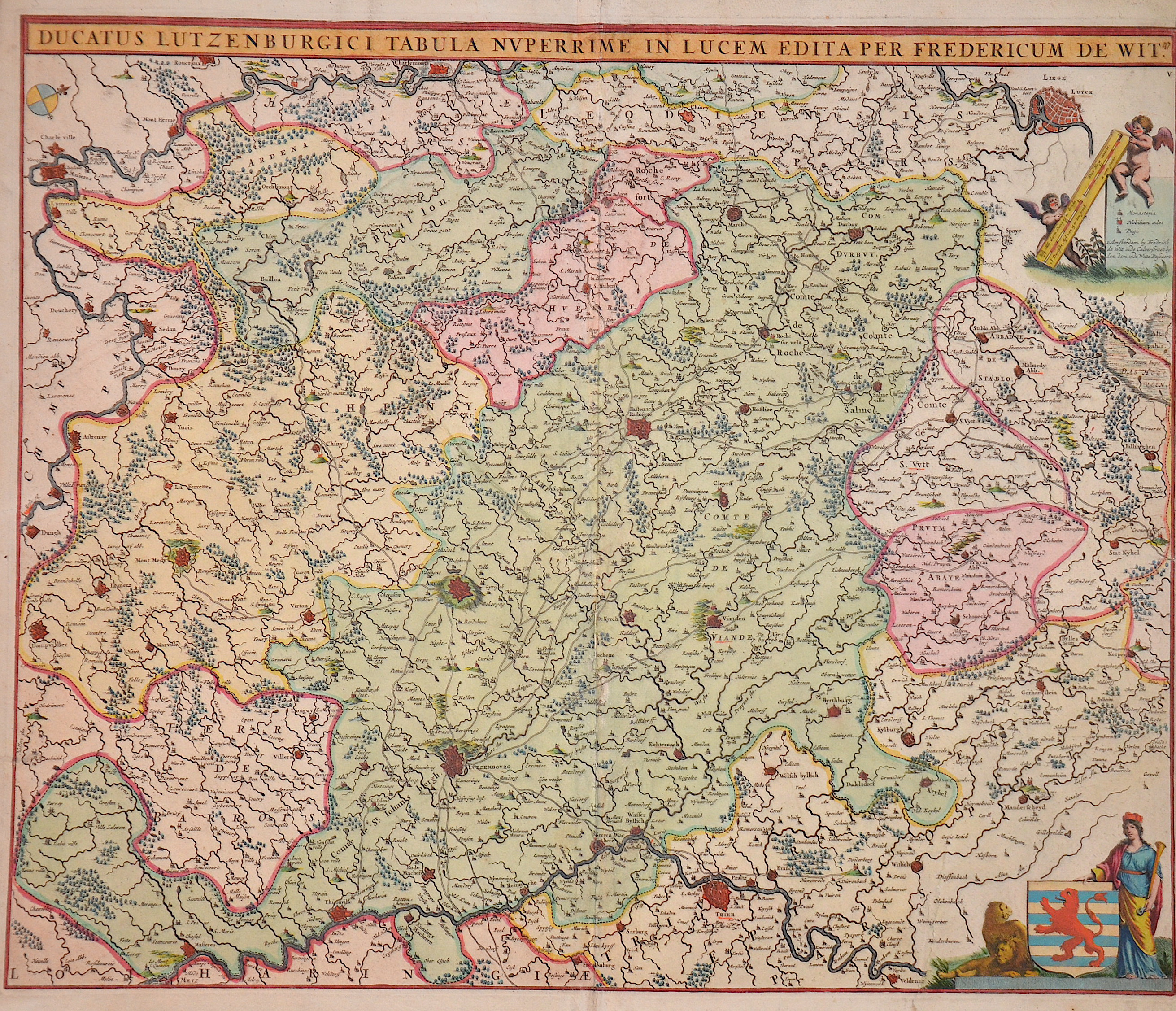
Ducatus Lutzenburgici Tabula Nuperrime in Lucem edita per Fredericum de Wit.

| Article ID | EUB5263 |
Title | Ducatus Lutzenburgici Tabula Nuperrime in Lucem edita per Fredericum de Wit. |
Description | Map shows the area around Luxembourg up to the cities of Charleville, Liège and Trier. There is also a title cartouche with the coat of arms of Luxembourg, a compass rose and a mileage indicator held by two putti. |
| Year | ca. 1670 |
Artist | Wit, de (1610-1698) |
Frederik de Wit (1610 – 1698). His Atlas began to appear around 1662 and by 1671 included anywhere from 17 to 151 maps each. In the 1690s he began to use a new title page "Atlas Maior" but continued to use his old title page. His atlas of the Low Countries first published in 1667,was named Nieuw Kaertboeck van de XVII Nederlandse Provinciën and contained 14 to 25 maps. Frederik de Wit quickly expanded upon his first small folio atlas which contained mostly maps printed from plates that he had acquired, to an atlas with 27 maps engraved by or for him. By 1671 he was publishing a large folio atlas with as many as 100 maps. Smaller atlases of 17 or 27 or 51 maps could still be purchased and by the mid-1670s an atlas of as many as 151 maps and charts could be purchased from his shop. In ca.1675 Frederik de Wit released a new nautical atlas. The charts in this atlas replaced the earlier charts from 1664 that are known today in only four bound examples and a few loose copies. Frederik de Wit new charts were sold in a chart book and as part of his atlases. Frederik de Wit published no fewer than 158 land maps and 43 charts on separate folio sheets. In 1695 Frederik de Wit began to publish a town atlas of the Netherlands after he acquired a large number of city plans at the auction of the famous Blaeu publishing firm’s printing plates. Dating Frederik de Wit atlases is considered difficult because usually no dates were recorded on the maps and their dates of publication extended over many years. | |
Historical Description | Luxembourg has undergone a remarkable development throughout its history. From a small county in the Middle Ages to a strategically important area during the major wars of Europe, and eventually to a modern, prosperous country within the European Union, Luxembourg has established itself as an independent and stable state. The early history of Luxembourg was strongly shaped by Roman and later Frankish rule. During the Roman period, the area was part of the empire, and in the Middle Ages, it belonged to the Frankish kingdoms. In 1354, the Holy Roman Emperor Charles IV elevated Luxembourg to a duchy, making it an important territorial possession in the Holy Roman Empire. In the 16th century, Luxembourg came under the control of the Habsburgs, who held both the Spanish and Austrian inheritances. Under Spanish rule, Luxembourg was used as a strategic point in the wars between Spain and the Netherlands. In 1795, during the French Revolution, Luxembourg was conquered by the French and incorporated into the French Empire. In 1839, after the Belgian Revolution, Luxembourg was divided between Belgium and the Kingdom of the Netherlands. The western part of the country fell to Belgium, while the eastern part remained with the Netherlands. This division shaped Luxembourg's modern geographical boundaries and gave it its current form. Today, Luxembourg is a constitutional monarchy and one of the wealthiest countries in the world. |
| Place of Publication | Amsterdam |
| Dimensions (cm) | 46 x 55 cm |
| Condition | Some restoration at centerfold |
| Coloring | original colored |
| Technique | Copper print |