

Adina Sommer
Antique and Contemporary Art
Winzerer Str. 154
80797 München
telephone
+49 89 304714
business hours:
by appointment
Email
![]()


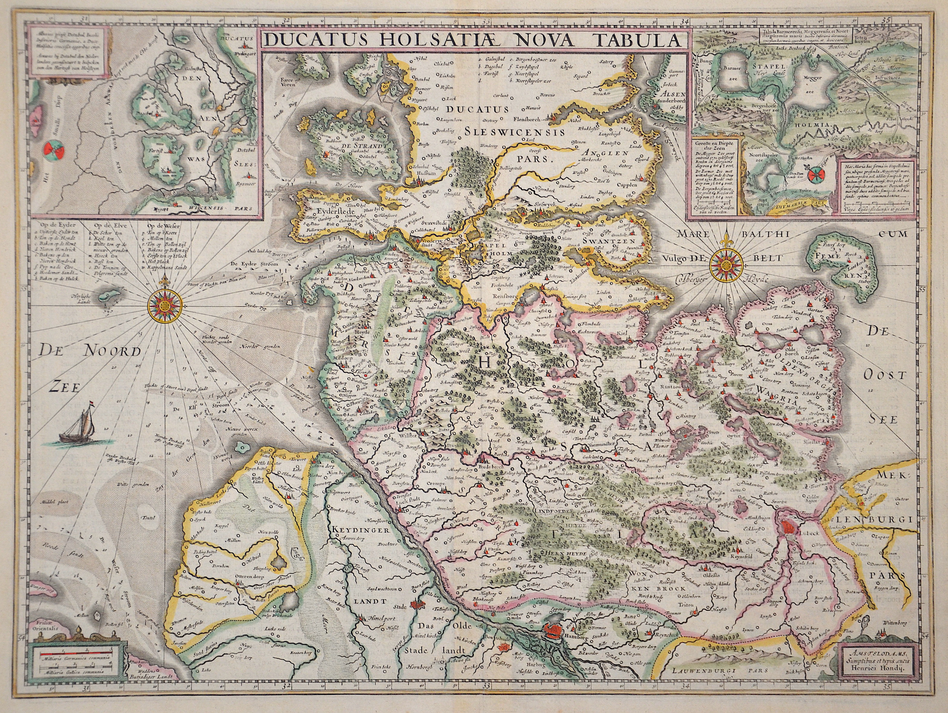
Ducatus Holsatiae Nova Tabula

| Article ID | EUD4740 |
Title | Ducatus Holsatiae Nova Tabula |
Description | Map shows Schleswig Holstein with the cities of Hamburg, Lübeck, Husum and many more. Furthermore, two wind roses, a sailing ship and two partial maps with the land gains near Husum and Niebüll, Börmerkoog and Meggerkoog in Stapelholm. |
| Year | ca. |
Artist | Hondius (1597-1650) |
Jodocus Hondius (1563 –1612) was a Dutch engraver, and cartographer. He is best known for his early maps of the New World and Europe, for re-establishing the reputation of the work of Gerard Mercator, and for his portraits of Francis Drake. He helped establish Amsterdam as the center of cartography in Europe in the 17th century. He was born in Wakken and grew up in Ghent. In his early years he established himself as an engraver, instrument maker and globe maker. In 1584 he moved to London to escape religious difficulties in Flanders. While in England, Hondius was instrumental in publicizing the work of Francis Drake, who had made a circumnavigation of the world in the late 1570s. In particular, in 1589 Hondius produced a now famous map of the bay of New Albion, where Drake briefly established a settlement on the west coast of North America. Hondius' map was based on journal and eyewitness accounts of the trip and has long fueled speculation about the precise location of Drake's landing, which has not yet been firmly established by historians. Hondius is also thought to be the artist of several well-known portraits of Drake that are now in the National Portrait Gallery in London. In 1593 he moved to Amsterdam, where he remained until the end of his life. In co-operation with the Amsterdam publisher Cornelis Claesz. in 1604 he purchased the plates of Gerard Mercator's Atlas from Mercator's grandson. Mercator's work had languished in comparison to the rival Theatrum Orbis Terrarum by Ortelius. Hondius republished Mercator's work with 36 additional maps, including several which he himself had produced. Despite the addition of his own contributions, Hondius gave Mercator full credit as the author of the work, listing himself as the publisher. Hondius' new edition of Mercator's work was a great success, selling out after a year. Hondius later published a second edition, as well as a pocket version Atlas Minor. The maps have since become known as the ""Mercator/Hondius series"" . In the French edition of the Atlas Minor we find one of the first instances of a thematic map using map symbols. This is a map entitled Designatio orbis christiani (1607) showing the dispersion of major religions. Between 1605 and 1610 he was employed by John Speed to engrave the plates for Speed's The Theatre of the Empire of Great Britaine. Hondius died, aged 48, in Amsterdam. After his death, his publishing work in Amsterdam was continued by his widow, two sons, Jodocus II and Henricus, and son-in-law Johannes Janssonius, whose name appears on the Atlas as co-publisher after 1633. Eventually, starting with the first 1606 edition in Latin, about 50 editions of the Atlas were released in the main European languages. In the Islamic world, the atlas was partially translated by the Turkish scholar Katip Çelebi. The series is sometimes called the ""Mercator/Hondius/Janssonius"" series because of Janssonius's later contributions. | |
Historical Description | After the Angling wave of emigration, Danish and Jutian settlers advanced northeast into the country. Around 770 they founded Haithabu, one of the most important trading centers of the early Middle Ages, and with the Danewerk they built a protective wall against the Saxons. In the course of the Saxon Wars, the southern part of the country came under the influence of the Franconian Empire. Between 768 and 811 there were repeated confrontations between the King of the Franconian Empire and later Christian Emperor Charlemagne and the pagan northern Germans, in the course of which the Danewerk was expanded. In a peace treaty in 811, the Eider was established as the border between the Carolingian and Danish empires. With the increasing settlement in the 12th and 13th centuries, the Eider border lost its real meaning as a dividing line, but it remained until the end of the Holy Roman Empire in 1806 and until 1864 as the border between Schleswig and Holstein. In the early 13th century the Danish king tried to integrate Holstein into his empire. However, after initial successes, it failed in the Battle of Bornhöved in 1227 due to resistance from north German princes. In 1460, after the Schauenburgs died out, the Schleswig-Holstein knighthood directly elected the Danish King Christian I from the House of Oldenburg as sovereign, he was a nephew of the last Schauenburger Adolf VIII. While the Thirty Years War broke out in the south of the empire in 1618, they stayed Schleswig and Holstein were spared fighting for the time being and experienced a high phase due to the profitable agriculture. n the course of the 17th century, the contrast between the ducal and royal parts led to increasing conflicts between the two parties. The Gottorf Duchy demanded greater sovereignty and turned away from Denmark and instead turned to the Kingdom of Sweden. This culminated at the end of the century in a multiple occupation of the ducal portion by Denmark. The Great Northern War broke out at the beginning of the 18th century. Gottorf stood on the side of Sweden, which after the defeat of the kingdom in 1713 led to the complete annexation of the ducal share in Schleswig by Denmark. The former Gottorf Duchy then only had holdings in Holstein, the annexation was declared legal in the Peace of Frederiksborg in 1720. In 1800 the whole of Schleswig-Holstein - with the exception of the Principality of Lübeck and the Duchy of Saxony-Lauenburg - was under Danish administration. The city of Altona, today a district of Hamburg, was the second largest city in the kingdom after Copenhagen. At the end of the Napoleonic Wars, Denmark found itself on the loser's side with broken finances. The emergence of nationalism in both Denmark and Germany led to a contradiction in terms of who the so-called Elbe duchies belonged to, which resulted in two wars. In both Germany and Denmark, the country was fully claimed by the nationally-minded liberals, although it was divided into a predominantly Danish-speaking and Danish-minded north and a predominantly German-speaking and German-minded south. The disagreement between the two areas led to the Schleswig-Holstein uprising, in which the German-minded people tried in vain to end Danish sovereignty. The London Protocol of 1852 guaranteed the continued existence of the entire state and stipulated that Schleswig should not be bound closer to the kingdom than Holstein, and the entire state was restored. |
| Place of Publication | Amsterdam |
| Dimensions (cm) | 38 x 51 cm |
| Condition | Perfect condition |
| Coloring | original colored |
| Technique | Copper print |