

Adina Sommer
Antique and Contemporary Art
Winzerer Str. 154
80797 München
telephone
+49 89 304714
business hours:
by appointment
Email
![]()


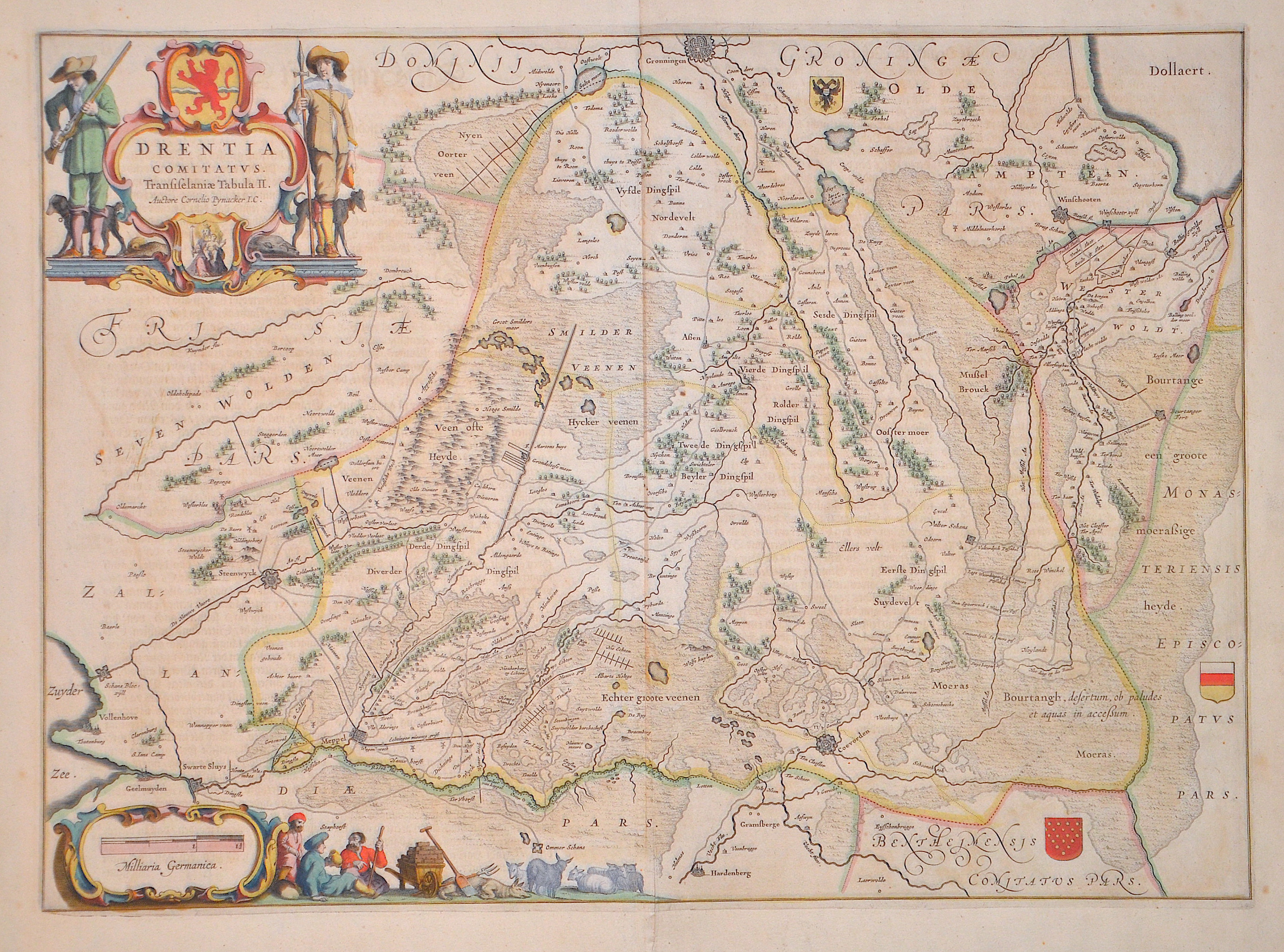
Drentia Comitatus. Transiselaniæ tabula II. Auctore Cornelio Pynacker I.C.

| Article ID | EUN5286 |
Title | Drentia Comitatus. Transiselaniæ tabula II. Auctore Cornelio Pynacker I.C. |
Description | Splendid map showing the county/province of Drenthe. Second map of Overijssel with the cities of Coevorden, Steenwijk, Groningen, Winschoten, Meppel and Assen. With a title cartouche and the coat of arms of the province of Drenthe and the province of Overijssel as well as a mileage scale cartouche and three coats of arms in the country. From ‘Theatrum Orbis Terrarum, sive Atlas Novus in quo Tabulæ et Descriptiones Omnium Regionum, Editæ a Guiljel et Ioanne Blaeu’ |
| Year | ca. 1645 |
Artist | Blaeu (1571-1638) |
Joan Guilliemus Blaeu was the eldest son of Willem Janszoon Blaeu (1571-1638), and was probably born in Alkmaar in the province of Noord-Holland in the final years of the 16th century. He was brought up in Amsterdam, and studied law at the University of Leiden before going into partnership with his father in the 1630s. Although his father Willem had cartographic interests, having studied under the Danish astronomer Tycho Brahe and having manufactured globes and instruments, his primary business was as a printer. It was under the control of Joan that the Blaeu printing press achieved lasting fame by moving towards the printing of maps and expanding to become the largest printing press in Europe in the 17th century. By the 1660s the Theatrum Orbis Terrarum (or Atlas Maior as it had became known by this time) had expanded to between 9 and 12 volumes, depending on the language. With over 3,000 text pages and approximately 600 maps, it was the most expensive book money could buy in the later 17th century. The translation of the text from Latin into Dutch, English, German, French, and Spanish for several volumes created enormous work for those involved in typography and letterpress activities. It is estimated that over 80 men must have been employed full-time in the Blaeu printing house in Bloemgracht, not including engravers who worked elsewhere, with over 15 printing presses running simultaneously, and in 1667 a second press was acquired at Gravenstraat. At the same time as producing the Atlas Maior, Blaeu was also publishing town plans of Italy, maps for globes, and other volumes. At its peak the Blaeu press managed to produce over 1 million impressions from 1,000 copper plates within four years. | |
Historical Description | The County of Drenthe was a province of the Holy Roman Empire from 1046, and of the Dutch Republic from 1581 until 1795. It corresponds to the area west of the lower Ems, today the eponymous province of Drenthe in the Netherlands. Between 1225 and 1240, the free peasants of Drenthe were in conflict with the bishops over his lordship and his tithes. In 1412, the county received its own Landrecht (territorial law). In 1522, during the Guelders Wars, the county fell to Charles II, Duke of Guelders, but he was forced to cede it to the Habsburg emperor Charles V in the Treaty of Grave of 1536. It was thereafter governed by a Habsburg stadtholder, but because it was only sparsely populated, it had the same stadtholder as the Lordship of Groningen. In the Treaty of Augsburg of 1548, Drenthe was removed from the Westphalian Circle and attached to the Burgundian Circle, making it one of the Seventeen Provinces of the Habsburg Netherlands with a special status within the Empire. |
| Place of Publication | Amsterdam |
| Dimensions (cm) | 38 x 52 cm |
| Condition | Some browning |
| Coloring | original colored |
| Technique | Copper print |