

Adina Sommer
Antique and Contemporary Art
Winzerer Str. 154
80797 München
telephone
+49 89 304714
business hours:
by appointment
Email
![]()


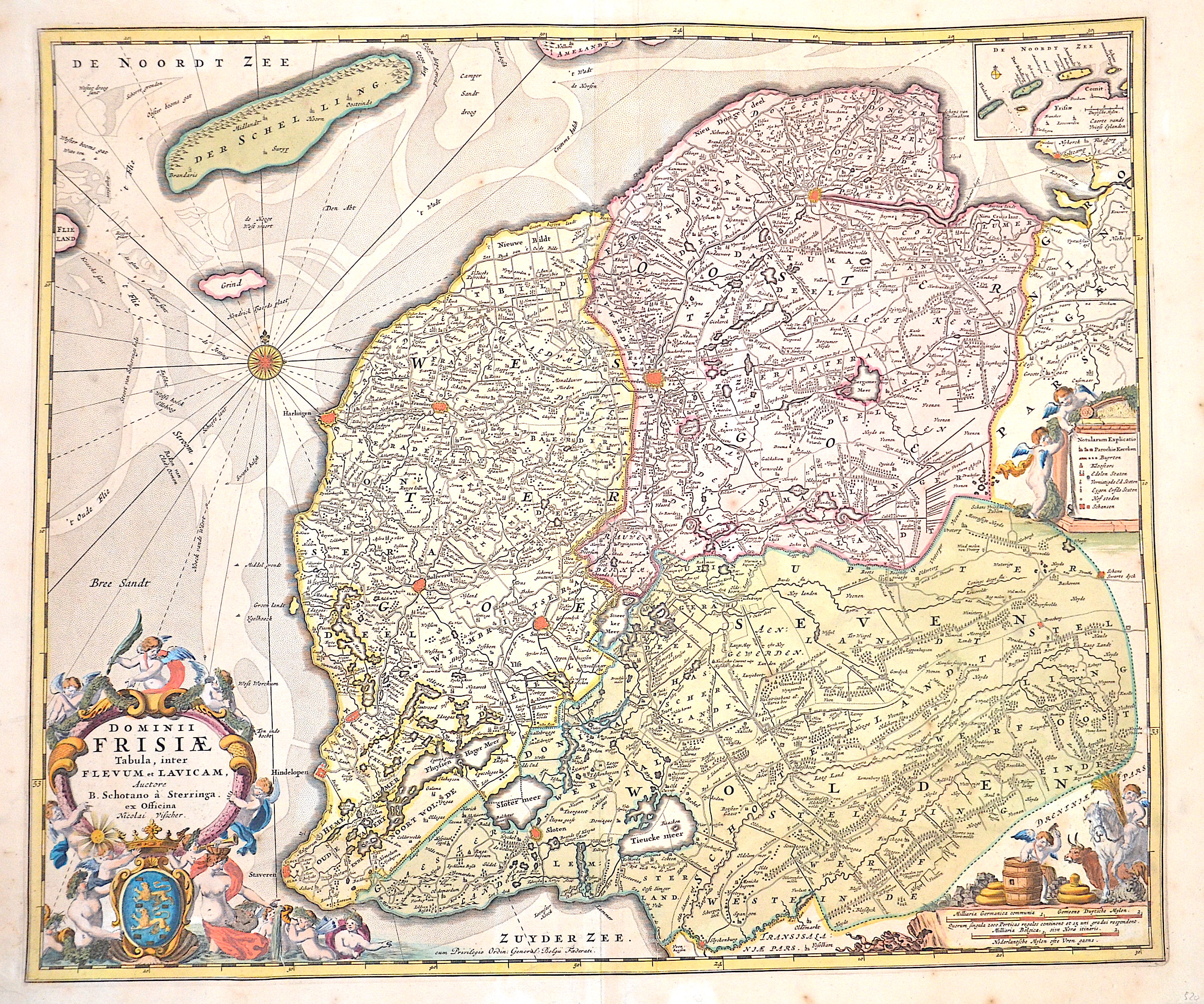
Dominii Frisiae Tabula, inter Flevum et Lavicam,..

| Article ID | EUB4952 |
Title | Dominii Frisiae Tabula, inter Flevum et Lavicam,.. |
Description | Map shows Friesland in the north of the Netherlands with the towns of Dokkum, Leeuwarden, Harlingen, in the south to Stavoren and Sleat. Furthermore the island of Terschelling, at the top right a partial map with the West Frisian islands Vlieland, Terschelling, Ameland and Schiermonnikoog. With three magnificent cartouches, a compass rose and the coat of arms of Friesland. |
| Year | ca. 1660 |
Artist | Visscher (1618-1679) |
Nicolaes Visscher I (1618 -1679) Amsterdam was a Dutch engraver, cartographer and publisher. He belonged to the Dutch art dealer, engraver and publisher dynasty founded by his father Claes Janszoon Visscher. After his father's death in 1652, he took over his father's art publishing house and initially continued publishing the atlases and maps that his father had begun. He then began publishing works under his own name. Together with his son Nicolaes Visscher II (1649-1702), he engraved a large number of printing plates, further replenishing the publisher's stock. The atlases "Atlas Contractus", "Atlas Minor" and "Germania Inferior" contain about 170 plates. After N. Visscher's death, some of Visscher's copper plates passed to Petrus Schenk II (1693-1775), who used them for numerous reprints. | |
Historical Description | After the division of the Franconian Empire, the lower lands belonged to the East Franconian Kingdom (Regnum Teutonicum) and then to the Holy Roman Empire. Under Emperor Charles V, who was also King of Spain, the country was divided into seventeen provinces and also included what is now Belgium and parts of northern France and western Germany. The rift between Catholics loyal to Spain and radical Calvinists was torn too deep and led to the Calvinist provinces of Holland, Zeeland and Utrecht joining together in a defensive alliance in 1579, the Union of Utrecht. This treaty became the charter of a new state, the Republic of the United Netherlands. Only after an eighty-year war was the independence of the Netherlands from Spain recognized in the Peace of Westphalia in May 1648. This date is considered the birthday of today's Netherlands. As a result, as the republic of the Seven United Provinces, the Netherlands grew to become the greatest trading and economic power of the 17th century. This era is known as the Golden Age. However, this did not come from the state, but from the first two public companies in history, the Dutch East India Company (VOC) and the Dutch West India Company (WIC). The founding of New Amsterdam is well known (Nieuw Amsterdam), which was later renamed New York. In Asia, the Dutch created their colonial empire, the Dutch East Indies, what is now Indonesia. The Netherlands also gained colonies in northeastern South America. In Europe, the Netherlands was a great power in the 17th century, led by bourgeois politicians like Johan van Oldenbarnevelt and Johan de Witt. |
| Place of Publication | Amsterdam |
| Dimensions (cm) | 47 x 55,5 cm |
| Condition | Some restorations due to original color, mounted. |
| Coloring | original colored |
| Technique | Copper print |