

Adina Sommer
Antique and Contemporary Art
Winzerer Str. 154
80797 München
telephone
+49 89 304714
business hours:
by appointment
Email
![]()


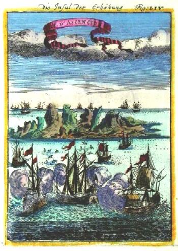
Die Insul der Erhöhung, Isle de Ascencion

| Article ID | AF0152 |
Title | Die Insul der Erhöhung, Isle de Ascencion |
Description | Map shows the Island Ascencion in the atlantic ocean near St. Helena. |
| Year | ca. 1684 |
Artist | Mallet (1630-1706) |
Alain Manesson Mallet (1630- 1706 ) was a French cartographer and engineer. He started his career as a soldier in the army of Louis XIV, became a Sergeant-Major in the artillery and an Inspector of Fortifications. He also served under the King of Portugal, before returning to France, and his appointment to the court of Louis XIV. His military engineering and mathematical background led to his position teaching mathematics at court. His major publications were Description de L'Univers (1683) in 5 volumes, and Les Travaux de Mars ou l'Art de la Guerre (1684) in 3 volumes. His Description de L'Universe contains a wide variety of information, including star maps, maps of the ancient and modern world, and a synopsis of the customs, religion and government of the many nations included in his text. It has been suggested that his background as a teacher led to his being concerned with entertaining his readers. This concern manifested itself in the charming harbor scenes and rural landscapes that he included beneath his description of astronomical concepts and diagrams. Mallet himself drew most of the figures that were engraved for this book. | |
Historical Description | Ascension, a large tropical island in the South Atlantic between Africa and South America. The originally uninhabited island was probably first discovered by João da Nova in May 1501. According to tradition, he gave it the name Ascensão because he is said to have sighted it on the Ascension of Christ (Ascensão de Jesus in Portuguese). However, this common account of the discovery and naming of the island has since been challenged, as the island already appears on the Cantino world map of 1502 as ilha ... ascenssani in the correct location. In 1701, the explorer William Dampier ran aground with his ship Roebuck in front of the island and held out with his crew for six weeks before an East India sailor picked up the castaways. Thus, the privateer and his crew are considered the first settlers on the island. When Napoleon Bonaparte was banished in 1815 to the island of St. Helena, about 700 nautical miles to the southeast, the Royal Navy occupied Ascension to make possible attempts at liberation by the French more difficult. The island was developed into a fortress. In November 1816, Christian Ignatius Latrobe, an inspector of the Moravian Church, visited the islands of St. Helena and Ascension on his return trip from the South African Moravian colony of Gnadenthal. Latrobe was looking for further settlement sites for the Herrnhut mission and was initially impressed by the beauty of Ascension Island. In 1836, Charles Darwin, coming from St. Helena, landed on Ascension aboard HMS Beagle. He was so enthralled by the island and its appearance that he, along with British biologist and botanist Joseph Dalton Hooker, began to develop a plan to revitalize this barren island. A kind of Garden of Eden or rather "Island of Eden" was to be created. |
| Place of Publication | Frankfurt on Main |
| Dimensions (cm) | 15 x 10,5 cm |
| Condition | Very good |
| Coloring | original colored |
| Technique | Copper print |