

Adina Sommer
Antique and Contemporary Art
Winzerer Str. 154
80797 München
telephone
+49 89 304714
business hours:
by appointment
Email
![]()


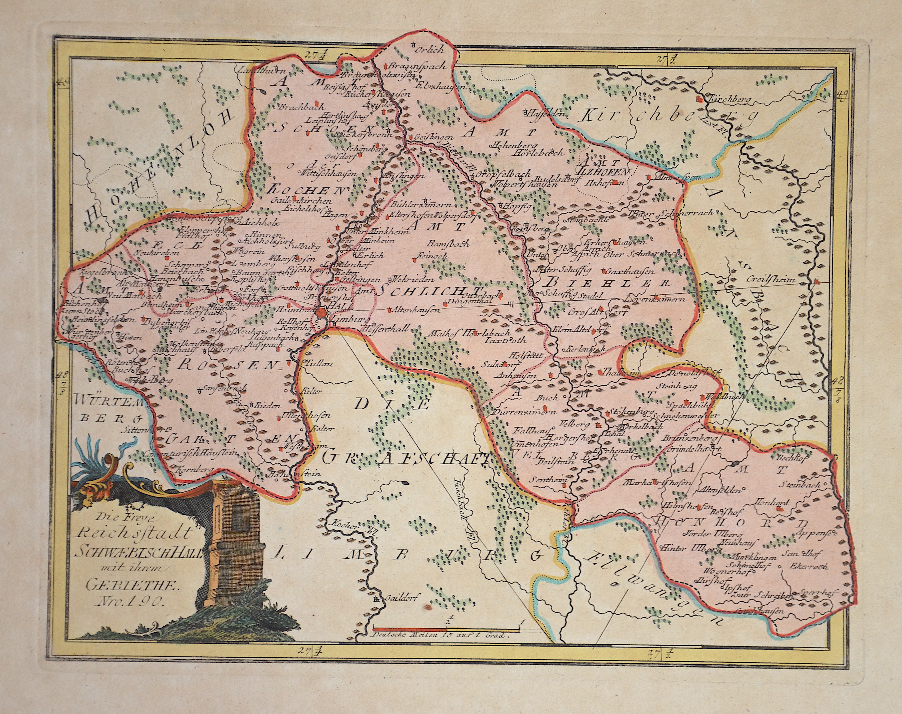
Die Freye Reichsstadt Schwaebisch Hall mit ihrem Gebiethe. Nro. 190

| Article ID | EUD4943 |
Title | Die Freye Reichsstadt Schwaebisch Hall mit ihrem Gebiethe. Nro. 190 |
Description | Map shows the area around Schwäbisch Hall with Rosengarten, Markertshofen, Ilshofen, Braunsbach and many more. With title cartouche and mile pointer. |
| Year | ca. 1792 |
Artist | Reilly (1766-1820) |
Franz Johann Joseph von Reilly (1766 - 1820) Vienna. Franz Johann Joseph von Reilly was an Austrian publisher, cartographer and writer. He was born the son of the court master Johann Reilly. He initially worked in the civil service, but then devoted himself exclusively to geography. From 1789 to 1806, he produced the atlas Schauplatz der fünf Theile der Welt, which only covers Europe on its 830 sheets. After the Schul Atlas (1791-92) and the Allgemeine Erdbeschreibung (3 volumes, 1792-93), he published the first (complete) Austrian world atlas entitled Grosser deutscher Atlas from 1794 to 1796. In 1796, he produced the series Geschichtliche und bildliche Vorstellung der Regimenter des Erzhauses Oesterreich (Historical and Pictorial Presentation of the Regiments of the Archduke of Austria), and in 1799 the Allgemeine Post Atlas von der ganzen Welt (General Postal Atlas of the Whole World) - the first atlas of its kind in the world. | |
Historical Description | Baden-Wuertemberg is a state in southwest Germany, east of the Rhine, which forms the border with France. It is is formed from the historical territories of Baden, Prussian Hohenzollern, and Württemberg, and also parts of Swabia. Baden Würtemberg was only founded in 1952 by the merger of the states of Württemberg-Baden, Baden and Württemberg-Hohenzollern. Today the most populous city of Baden-Württemberg is the state capital Stuttgart, followed by Karlsruhe and Mannheim. Other major cities are Freiburg im Breisgau, Heidelberg, Ulm, Heilbronn, Pforzheim and Reutlingen. The early modern period was marked by the Reformation and the expansion efforts of the emerging states of Austria, Prussia, France and Sweden. Conflicts such as the Peasant War, the Thirty Years' War and the Palatinate War of Succession resulted from these. One of the focal points of the fighting, with corresponding consequences for the population and the economy, was in what is today Baden-Württemberg, which remained extremely fragmented territorially. At the beginning of the 19th century, around 300 states still had territorial rights in what is now Baden-Württemberg, but their number was reduced to four after the dissolution of the Old Empire. The Kingdom of Württemberg and the Grand Duchy of Baden were among the winners of the coalition wars. The two principalities of Hohenzollern-Sigmaringen and Hohenzollern-Hechingen survived mediatization due to their special relationship with Napoléon. In 1849, the Baden Revolution was put down by Prussian intervention forces, the Baden army was dissolved and rebuilt under Prussian leadership. In 1850 the two Hohenzollern states became the Prussian province of Hohenzollernsche Lande. With the new formation of the tribal duchies, the southern areas of what is now the state of Baden-Württemberg belonged to the Duchy of Swabia until the end of the High Middle Ages, the northern areas were located with the Duchy of Franconia. |
| Place of Publication | Vienna |
| Dimensions (cm) | 22,5 x 28,5 cm |
| Condition | Some browning |
| Coloring | original colored |
| Technique | Copper print |