

Adina Sommer
Antique and Contemporary Art
Winzerer Str. 154
80797 München
telephone
+49 89 304714
business hours:
by appointment
Email
![]()


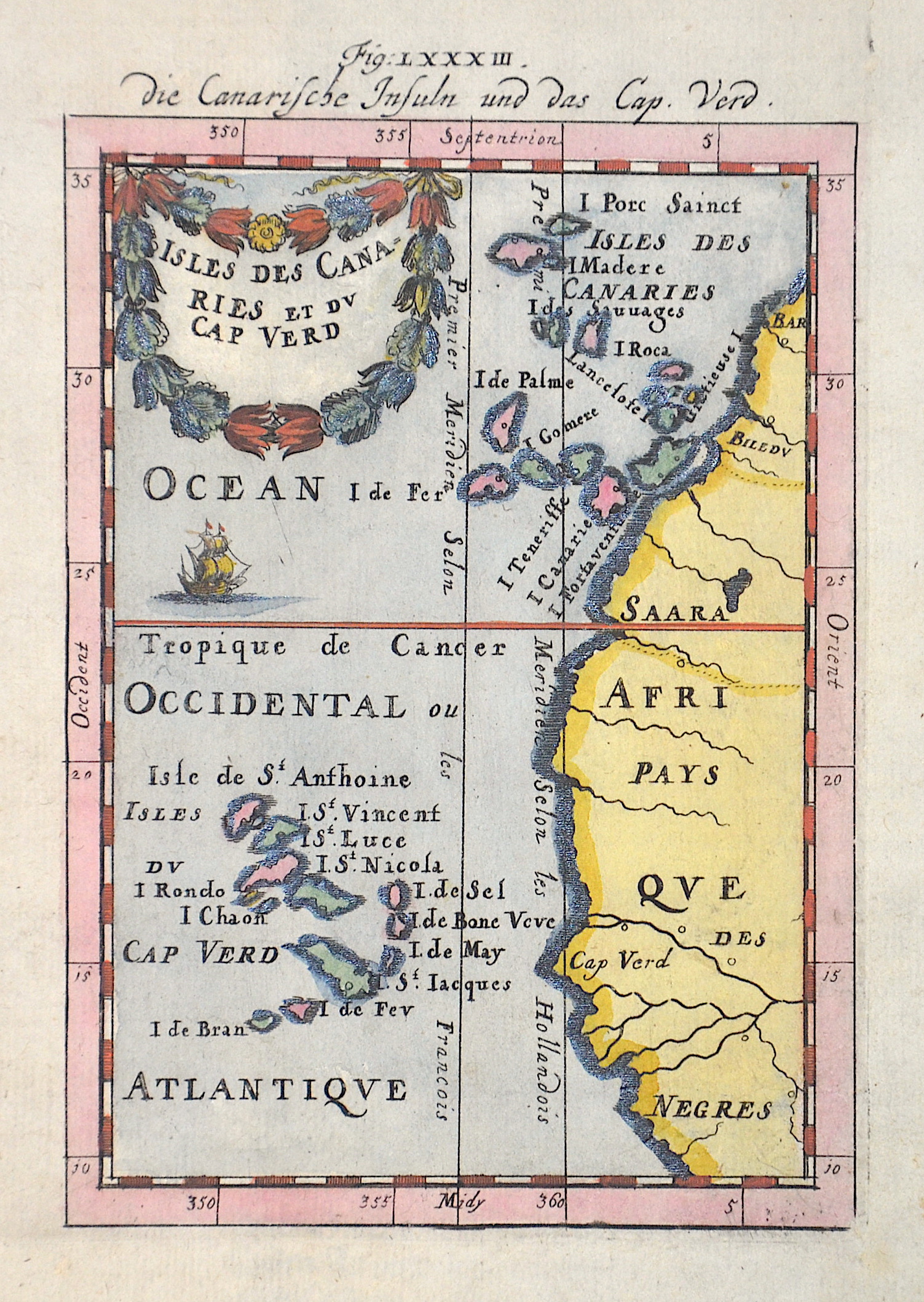
Die Canarische Insuln und das Cap Verd

| Article ID | EUE2174 |
Title | Die Canarische Insuln und das Cap Verd |
Description | Map shows the Canary Islands with the Capverdian Islands and the North West Coast of Africa. Canary Islands with Tenerife, Fuerteventura, Gran Canaria, Lanzarote, La Palma, La Gomera and El Hierro. |
| Year | ca. 1684 |
Artist | Mallet (1630-1706) |
Alain Manesson Mallet (1630- 1706 ) was a French cartographer and engineer. He started his career as a soldier in the army of Louis XIV, became a Sergeant-Major in the artillery and an Inspector of Fortifications. He also served under the King of Portugal, before returning to France, and his appointment to the court of Louis XIV. His military engineering and mathematical background led to his position teaching mathematics at court. His major publications were Description de L'Univers (1683) in 5 volumes, and Les Travaux de Mars ou l'Art de la Guerre (1684) in 3 volumes. His Description de L'Universe contains a wide variety of information, including star maps, maps of the ancient and modern world, and a synopsis of the customs, religion and government of the many nations included in his text. It has been suggested that his background as a teacher led to his being concerned with entertaining his readers. This concern manifested itself in the charming harbor scenes and rural landscapes that he included beneath his description of astronomical concepts and diagrams. Mallet himself drew most of the figures that were engraved for this book. | |
Historical Description | The uninhabited islands were circled by António Fernandes in 1445 and discovered and entered for the first time in 1456 by the Venetian Alvise Cadamosto, who was in Portuguese service (Boa Vista). Antonio da Noli, a Genoese captain who also sailed on behalf of the Portuguese Prince Henry the Navigator, continued to explore the islands from 1458 in collaboration with Diogo Gomes, discovered most of the rest of the eastern Cape Verde Islands and baptized the archipelago with the name Ilhas de Cabo Verde and began settling the islands as governor of the Portuguese crown from 1461. In fact, Diogo Gomes later claimed to be the first of the two to have seen the island of Santiago from afar and also to have been the first to set foot on it. Antonio da Noli, however, managed to return to Portugal earlier, and he was then understandably rewarded by Heinrich the Navigator with the encouragement of the discovery, which, in the words of Diogo Gomes, "I, Gomes, discovered". Because of the rivalry between the two, Diogo Gomes is considered to be the true discoverer of the main island of Santiago in Portuguese historiography. The islands were named by the Portuguese after Cabo Verde (Green Cape) on the west coast of Africa. |
| Place of Publication | Frankfurt on Main |
| Dimensions (cm) | 15 x 10 cm |
| Condition | Perfect condition |
| Coloring | original colored |
| Technique | Copper print |