

Adina Sommer
Antique and Contemporary Art
Winzerer Str. 154
80797 München
telephone
+49 89 304714
business hours:
by appointment
Email
![]()


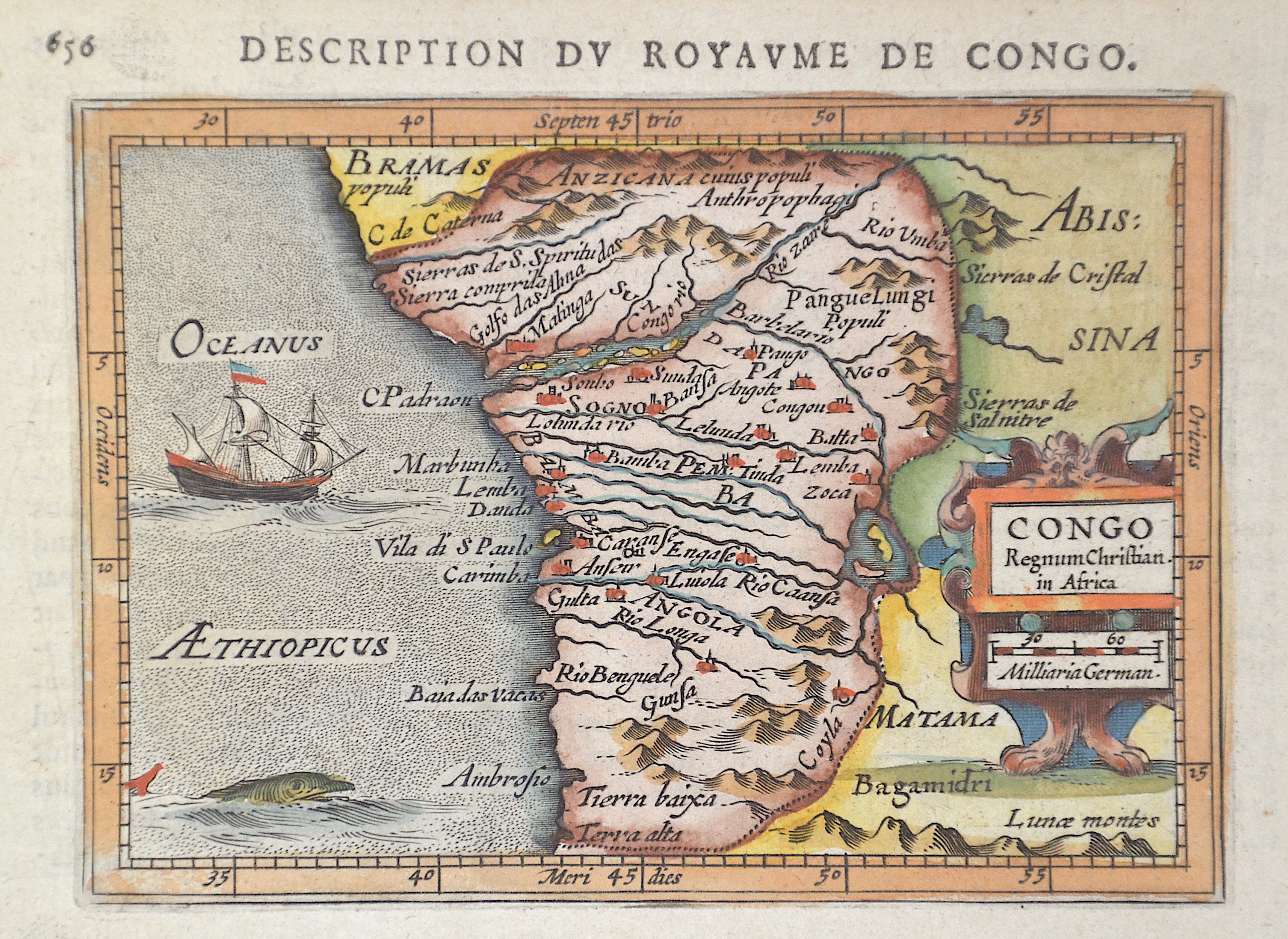
Description du royaume de Congo. / Congo Regnum Christian in Africa.

| Article ID | AF0526 |
Title | Description du royaume de Congo. / Congo Regnum Christian in Africa. |
Description | Map shows the African Republic of Congo (Democratic Republic of Congo) with a part of the Congo River up to its mouth into the Atlantic Ocean. The map shows rivers, mountains and cities in detail. With title cartouche, a sailing ship and a sea monster. |
| Year | ca. 1610 |
Artist | Bertius (1565-1629) |
Petrus Bertius (1565 -1629) was a Flemish theologian, historian, geographer and cartographer, He grew up in Beveren (Flanders). In 1593 he was appointed mathematics professor and librarian of the University of Leyden. His main cartographic work includes a miniature world atlas of 1600, a pocket atlas of the German Empire of 1616 with 26 engraved maps and 101 city views, a version of the Geographia of Ptolemy with 28 maps by Mercator and 14 maps from the Parergon of Ortelius of 1618, but he is known today as a cartographer with his edition of the Geographia of Ptolemy (based on Mercator's edition of 1578) and for his atlas. | |
Historical Description | The indigenous population of today's state consisted of pygmies, who are now only a small minority. Bantu peoples immigrated for centuries. Among the states there, the Kingdom of the Congo, founded in the 14th century and one of the largest African states ever, emerged. In the 15th century, Portuguese sailors around Diogo Cão explored the area of the Congo estuary and established diplomatic relations with the Congo Empire in 1491. From the 16th century onwards, the Congo Empire was in decline. By the end of the 17th century, the kingdom was completely destroyed, as well as being exploited and looted by slave hunters. After this collapse, the Portuguese supremacy was replaced by that of the Dutch and British. At the beginning of the 18th century the Congo Empire had almost completely disintegrated. In 1866 the last Portuguese left. In the 1870s, Henry Morton Stanley from Welsh was the first European to travel to the hinterland. He proposed that the Congo be incorporated into the British colonial empire. The British government refused because it was primarily interested in the sources of the Nile. The Democratic Republic of the Congo was originally administered as the Belgian Congo by a legislative assembly and regional assemblies made up of only Europeans appointed by colonial authorities. By the late 1950s there was a greater turnout of Africans, but not full voting rights until independence when the colony was renamed Zaire. With the global striving for independence in the colonies, the pressure for state self-determination also grew in the Congo. After the first unrest in the capital Léopoldville and under pressure from the global public, Belgium suddenly withdrew from the Congo in early 1959, leaving behind a chaos. In 1960 the Congo gained independence. |
| Place of Publication | Amsterdam |
| Dimensions (cm) | 10 x 13,5 cm |
| Condition | Perfect condition |
| Coloring | original colored |
| Technique | Copper print |