

Adina Sommer
Antique and Contemporary Art
Winzerer Str. 154
80797 München
telephone
+49 89 304714
business hours:
by appointment
Email
![]()


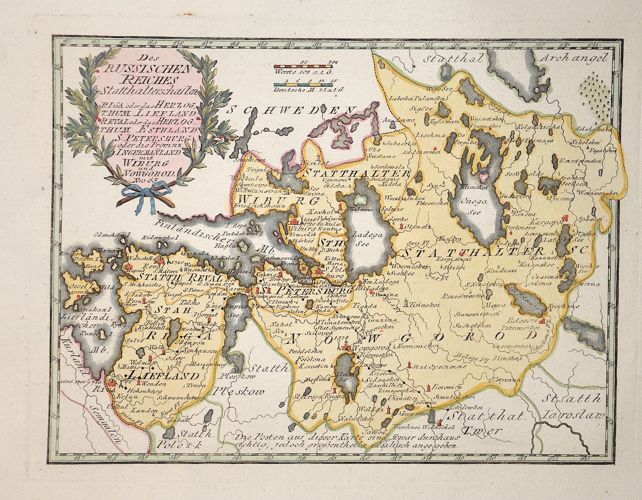
Des Russichen Reiches Statthalterschaften Riga oder das Herzogthum Livland, Reval oder das Herzogthum Esthland S.Petersburg ……

| Article ID | EUO2287 |
Title | Des Russichen Reiches Statthalterschaften Riga oder das Herzogthum Livland, Reval oder das Herzogthum Esthland S.Petersburg …… |
Description | Map shows Lettland and Estland with hat western part of Russia and the earea of St. Petersbourg |
| Year | ca. 1790 |
Artist | Reilly (1766-1820) |
Franz Johann Joseph von Reilly (1766 - 1820) Vienna. Franz Johann Joseph von Reilly was an Austrian publisher, cartographer and writer. He was born the son of the court master Johann Reilly. He initially worked in the civil service, but then devoted himself exclusively to geography. From 1789 to 1806, he produced the atlas Schauplatz der fünf Theile der Welt, which only covers Europe on its 830 sheets. After the Schul Atlas (1791-92) and the Allgemeine Erdbeschreibung (3 volumes, 1792-93), he published the first (complete) Austrian world atlas entitled Grosser deutscher Atlas from 1794 to 1796. In 1796, he produced the series Geschichtliche und bildliche Vorstellung der Regimenter des Erzhauses Oesterreich (Historical and Pictorial Presentation of the Regiments of the Archduke of Austria), and in 1799 the Allgemeine Post Atlas von der ganzen Welt (General Postal Atlas of the Whole World) - the first atlas of its kind in the world. | |
Historical Description | The Eastern European Plain occupies most of European Russia. It consists of wide lowlands interrupted by weakly indented ridges. Only a few elevations reach heights of more than 300 m. In Karelia and on the Kola Peninsula, which geologically belong to the Baltic Shield, the relief is more differentiated in the north. There, in the Chibines of the central Kola Peninsula, a maximum height of 1191 m is reached. In the south, the East European lowlands merge into the Caspian depression, which lies below sea level. During the last ice age a chain of terminal moraines was formed, which runs from the border area with Belarus eastward and north of Moscow to the Arctic coast west of the Pechora River. The region north of it consists of many lakes and swamps. The European part of the territory is much more densely populated and urbanized than the Asian part, which is over three times larger. The capital, Moscow, is one of the largest cities and metropolitan areas in the world. The second most important center is Saint Petersburg, which was the capital from 1712 to 1918 and is today an important cultural center. The next largest cities with over a million inhabitants are Novosibirsk, Yekaterinburg, Kazan and Nizhny Novgorod. In the European part of Russia, the most important river is the Volga. It is the longest river in Europe and runs exclusively through Russia. Together with its two tributaries Kama and Oka, it drains a large part of the East European Plain after 3534 km to the Caspian Sea in the southeast. As a waterway, the Volga has special significance, as it connects Eastern Europe with Central Asia. |
| Place of Publication | Vienna |
| Dimensions (cm) | 20,5 x 27,5 |
| Condition | Very good |
| Coloring | original colored |
| Technique | Copper print |