

Adina Sommer
Antique and Contemporary Art
Winzerer Str. 154
80797 München
telephone
+49 89 304714
business hours:
by appointment
Email
![]()


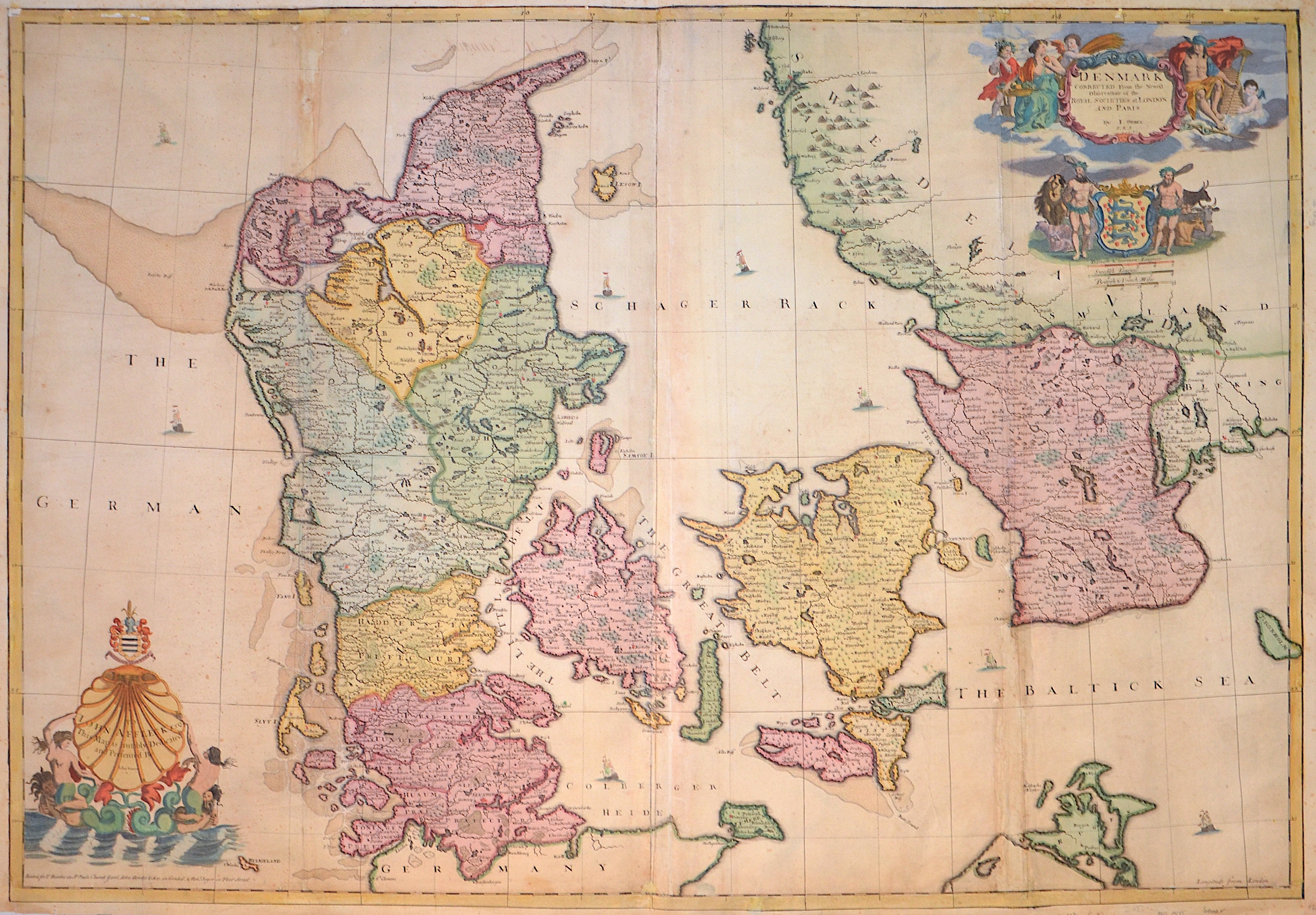
Denmark Corrected From the newest Observations of the Royal Societies at london and Paris

| Article ID | EUS1485 |
Title | Denmark Corrected From the newest Observations of the Royal Societies at london and Paris |
Description | Map shows the whole of Denmark with 2 magnificent cartouches, coats of arms and several ship staffages. Double-page engraved map on 2 sheets joined. |
| Year | ca. 1710 |
Artist | Senex (1678-1740) |
John Senex (1678, London – died 1740, London) was an English cartographer, engraver and explorer. He was also an astrologer, geologist, and geographer to Queen Anne of Great Britain, editor and seller of antique maps and most importantly creator of the pocket-size map of the world. He owned a business on Fleet Street, where he sold maps. A map of Rome by John Senex (1721). He was in particular, one of the principal cartographers of the 18th century. He started his apprenticeship with Robert Clavell, at the Stationers Company, in 1692. Senex is famous for his maps of the world, some of which have added elevations, and which feature minuscule detailed engravings. Many of these maps can be found in museum collections; rarely, copies are available for private sale. Some copies are held in the National Maritime Museum; many of his maps are now in the possession of Trinity College Dublin. Having worked and collaborated with Charles Price, Senex created a series of engravings for the London Almanacs and in 1714 he published together with Maxwell an English Atlas. In 1719 he published a miniature edition of Brittania by Ogilby. He became particularly interested in depicting California as an island instead of part of mainland North America, a trait which makes many of his maps appealing to collectors. In 1721 he published a new general atlas. He used the work of cartographer Guillaume de L’Isle as an influence. In 1728 Senex was elected into the Fellowship of the Royal Society of London. | |
Historical Description | Denmark is a country and sovereign state in Northern Europe and a parliamentary monarchy. Denmark is officially called the Kingdom of Denmark along with the Faroe Islands, which geographically belong to Northern Europe, like the mother country, and Greenland, which belongs to North America. The Danish people are said to have come from Scania to Jutland and the western Baltic islands in the 6th century, where they displaced other Germanic tribes. In the 10th century, Gorm the Old (around 950) united the individual minor kingdoms under his rule. Until 1035, when Knut the Great died, the Danish kings succeeded in conquering large parts of the British Isles. Until well into the 11th century, the Danes, Swedes and Norwegians, among others, were called Vikings, who founded colonies and traded throughout Europe. The only land border is between Denmark and Germany. A Danish minority lives in the former Danish southern Schleswig. With the Kalmar Union, Halland was suddenly in the center of the Danish Empire and, according to the Union Treaty, Erich of Pomerania should have been crowned in Halmstad. In the period that followed, Halland was not spared the wars of the era. In 1434, the landscape was conquered by the fighters of the Engelbrekt uprising and the Falkenberg castle was burned down. In the course of the Three Crown War, the Battle of Axtorna (also: Battle on the Falkenberger Haide) took place here in 1565, during which the Danish general Rantzau defeated a superior Swedish army. Until 1645 Halland belonged to Denmark and was then awarded in the peace of Brömsebro to Sweden for 30 years. Since the Peace of Roskilde in 1658, Halland has finally belonged to Sweden, although Denmark tried again in the Schoen War (1675–1679) to recapture lost territory. |
| Place of Publication | London |
| Dimensions (cm) | 66,5 x 96 cm |
| Condition | Marins replaced, missing parts in folding area on lower right and upper left side replaced |
| Coloring | original colored |
| Technique | Copper print |