

Adina Sommer
Antique and Contemporary Art
Winzerer Str. 154
80797 München
telephone
+49 89 304714
business hours:
by appointment
Email
![]()


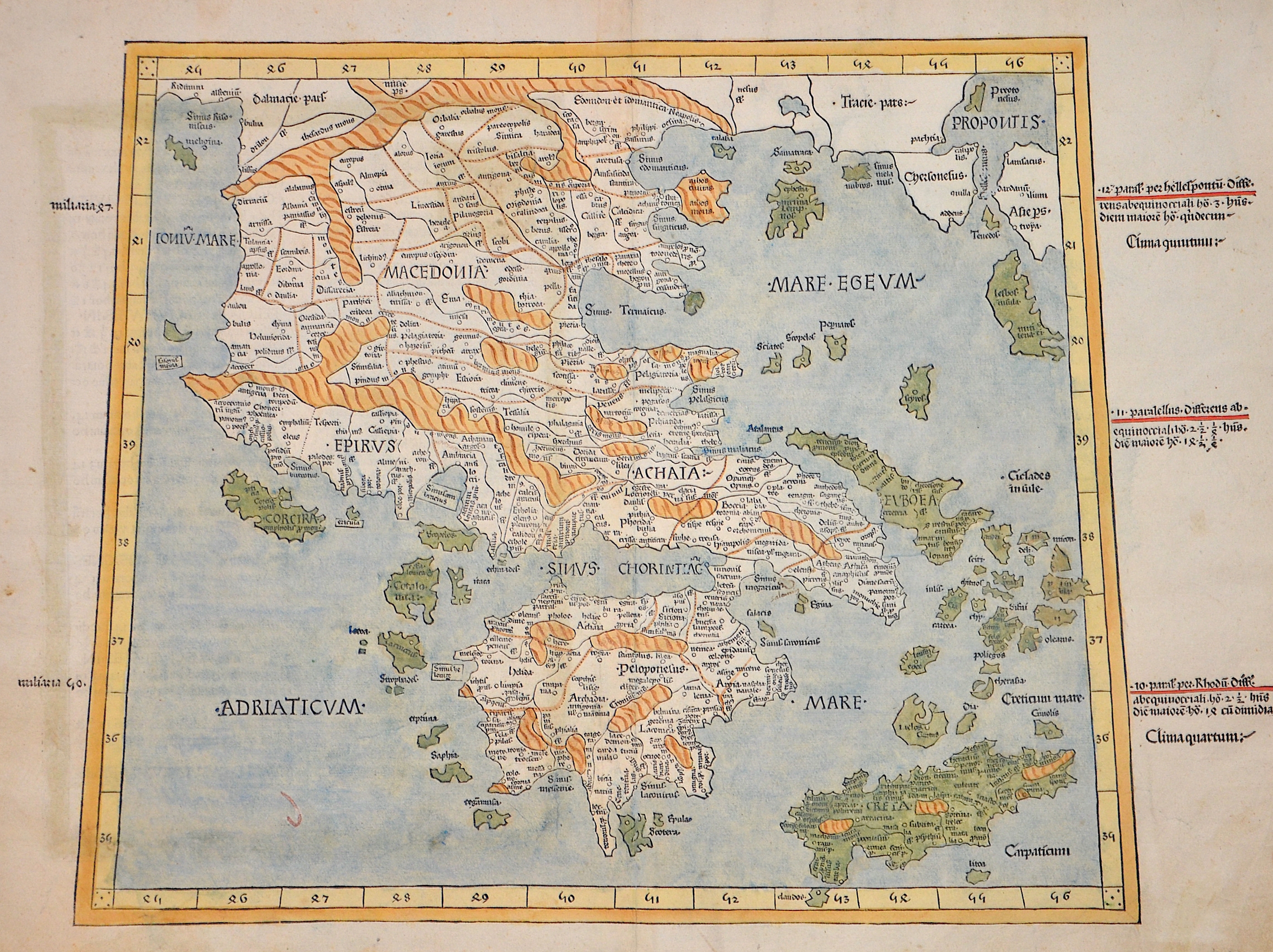
Decima Europe tabula continet Macedonia et epitu et Achaiam et Peloponesum

| Article ID | EUK5260 |
Title | Decima Europe tabula continet Macedonia et epitu et Achaiam et Peloponesum |
Description | Map shows the whole of Greece, the Aegean, Crete and the Bosporus. Text in Latin on the reverse. The map shows the region based on the writings of the Alexandrian mapmaker Claudius Ptolemy, who flourished in the second century AD and whose geographical text was translated into Latin and later inspired handwritten maps that used Ptolemy's table of geographical coordinates. The earliest surviving examples of such handwritten maps date from the beginning of the 14th century. These maps and Ptolemy's text were eventually combined in the 15th century, coinciding with the advent of printing, to form the most influential treatise on geography, leading to its widespread distribution in Europe and, ironically, eclipsing the work of other Greek geographers of the time, such as Strabo, whose work was probably more accurate than Ptolemy's calculations. |
| Year | ca. 1482 |
Artist | Ptolemy/Holle |
Lienhart Holle (? - 1492) was a German printer, living and working in Ulm. He is most noted for his 1482 Ptolemy, the first edition of Geographia printed north of the Alps. Some of the most important, and the most numerous, early printed maps were in editions of Ptolemy’s Geographia (Cosmographia); indeed, 31 editions of the work with the maps were printed before 1600. Some of the most important, and rarest, of these editions, including the Ulm Ptolemy from which this map originated, were the earliest editions of the work ever printed. The Ulm is also important for its world map is the earliest printed map to be signed by its maker, Johannes Schnitzer. The publication was the first project of Lienhart Holle, who had previously worked as a woodcut engraver. He wanted the work to be grand. A new type was cut for the atlas, Johannes of Armsheim cuts the block, and Holle oversaw the coloring of deluxe examples of the print run. However, the expense involved in producing the book was a bit too grand, Holle went bankrupt after printing just one other book and his stock was taken over by Johann Reger, who re-issued the atlas in 1486. Little is known of L. Holle´s life. He appears in the historical record in 1478 as a formschneider and woodcut dealer, among other things printing playing cards. He would then become the third book printer in Ulm, producing some outstanding works of the incunable period, most notably his edition of Ptolemy. Masterpiece though this was, it ruined him financially within two years of its publication. The elaborate designs of his books made them extravagantly expensive to produce, and he could only raise the capital by borrowing it, mortgaging his printing materials to a Venetian patron, Justus de Albano. As with many early printed works, a broad market failed to materialize, and Holle was unable to pay his debts. De Albano seized the blocks and typeset for nonpayment, and Holle was forced to flee Ulm in 1484. Whether he returned is unfortunately not known. | |
Historical Description | Greece is considered the cradle of Western civilisation, being the birthplace of democracy, Western philosophy, Western literature, historiography, political science, major scientific and mathematical principles, Western drama and the Olympic Games. From the eighth century B.C., the Greeks were organised into various independent city-states, known as poleis (singular polis), which spanned the entire Mediterranean region and the Black Sea. Philip of Macedon united most of the Greek mainland in the fourth century BC, with his son Alexander the Great rapidly conquering much of the ancient world, from the eastern Mediterranean to India. Greece was annexed by Rome in the second century B.C., becoming an integral part of the Roman Empire and its successor, the Byzantine Empire, which adopted the Greek language and culture. The Greek Orthodox Church, which emerged in the first century A.D., helped shape modern Greek identity and transmitted Greek traditions to the wider Orthodox World. After falling under Ottoman dominion in the mid-15th century, Greece emerged as a modern nation state in 1830 following a war of independence. |
| Place of Publication | Ulm |
| Dimensions (cm) | 37 x 53 cm |
| Condition | Small break point restored |
| Coloring | original colored |
| Technique | Wood engraving |