

Adina Sommer
Antique and Contemporary Art
Winzerer Str. 154
80797 München
telephone
+49 89 304714
business hours:
by appointment
Email
![]()


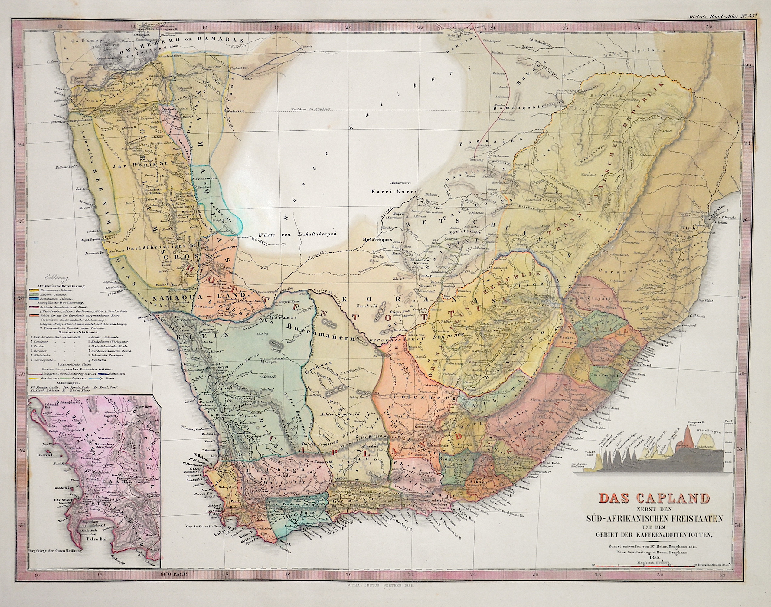
Das Capland nebst den Süd-Afrikanischen Freistaaten und dem Gebiet der Kaffern u. Hottentotten.

| Article ID | AF0517 |
Title | Das Capland nebst den Süd-Afrikanischen Freistaaten und dem Gebiet der Kaffern u. Hottentotten. |
Description | Map shows South Africa with its surrounding areas and a profile map. Furthermore, a partial map with Cape Town, Table Bay and False Bay at the Cape of Good Hope. From Stieler's Hand Atlas. |
| Year | c. 1855 |
Artist | Perthes (1749-1816) |
Johann Georg Justus Perthes ( 1749- 1816) was a German bookseller and publisher. Justus Perthes was the son of the Rudolstadt court physician Johann Justus Perthes. After training as a merchant, he obtained employment in the bookshop of Carl Wilhelm Ettinger in Gotha. Together with the latter and his later brother-in-law Friedrich Duerfeldt, he founded a company in 1778 to continue Ettinger's bookshop on his own. In September 1785, he founded Justus Perthes' Verlagsbuchhandlung, which from then on produced and distributed the Gothaische Genealogische Hofkalender, first published in 1763 and published by Ettinger, and its French edition, the Almanach de Gotha. Thanks to Perthes, the reference work soon known throughout Europe as "Der Gotha" was transformed from a calendar of the Enlightenment to an encyclopedia of the nobility with a diplomatic-statistical state handbook. In 1815, Perthes, together with the cartographers Adolf Stieler and Christian Gottlieb Reichard, planned the publication of an atlas, which was to be distinguished by "convenient format, the greatest possible accuracy, clarity and completeness, yet practical selection, uniformity of projection and scale, beautiful paper, good printing, careful illumination, and a reasonable price" and expand the publisher's program. In 1816, the year of Perthes' death, the first edition of Stieler's Hand-Atlas was published, which established the worldwide reputation of Justus Perthes' Geographical (Publishing) Institute Gotha - which only came into being after Perthes' death. | |
Historical Description | The term Southern Africa , refers to the southern part of the African continent. It includes Angola, Botswana, Democratic Republic of Congo, Eswatini, Comoros, Lesotho, Madagascar, Malawi, Mauritius, Mozambique, Namibia, Zambia, Seychelles, South Africa, Tanzania and Zimbabwe. According to the "Out-of-Africa theory", Africa is considered the "cradle of mankind", where homo development led to the development of the anatomically modern human Homo sapiens. One of the earliest advanced civilizations in mankind was formed in ancient Egypt. Over the millennia, various "great empires" such as the Empire of Abyssinia emerged on the continent. There were other kingdoms in West Africa, such as the Ashanti and Haussa, but they emerged much later. There were also some important cultures in East and South Africa, as in the area of today's Sudan, then called Nubia or Kush. Nubian pharaohs ruled all of Egypt for a dynasty. For example, the inhabitants of Greater Zimbabwe were important cultures in southern Africa. This stone castle was architecturally a masterpiece at that time and important for trade between the peoples of the south and east. The Swahili were known in East Africa. North Africa was connected to Europe and the Near East by the Mediterranean rather than separated. Carthage, a foundation of the Phoenicians in what is now Tunisia, was around the middle of the 1st millennium BC. The dominant power in the western Mediterranean until it was replaced by Rome in the Punic Wars. This prevailed from 30 BC. BC (conquest of Egypt) over all of North Africa. Even the ancient Egyptians (Queen Hatshepsut) made trips to Punt, probably in what is now Somalia. The kingdom of the Queen of Sheba, which probably had its center in southern Arabia, is said to have spanned parts of the Horn from Africa to the north of Ethiopia. |
| Place of Publication | Gotha |
| Dimensions (cm) | 32,5 x 42,5 cm |
| Condition | Perfect condition |
| Coloring | original colored |
| Technique | Steel engraving |