

Adina Sommer
Antique and Contemporary Art
Winzerer Str. 154
80797 München
telephone
+49 89 304714
business hours:
by appointment
Email
![]()


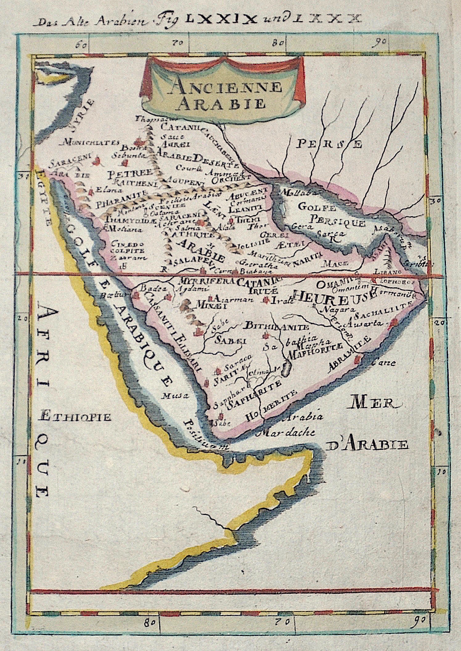
Das Alte Arabien Fig LXXIX und LXXX /Ancienne Arabie

| Article ID | ASA1070 |
Title | Das Alte Arabien Fig LXXIX und LXXX /Ancienne Arabie |
Description | Map shows total Arabia, partly the red sea and the Persian Gulf. |
| Year | ca. 1684 |
Artist | Mallet (1630-1706) |
Alain Manesson Mallet (1630- 1706 ) was a French cartographer and engineer. He started his career as a soldier in the army of Louis XIV, became a Sergeant-Major in the artillery and an Inspector of Fortifications. He also served under the King of Portugal, before returning to France, and his appointment to the court of Louis XIV. His military engineering and mathematical background led to his position teaching mathematics at court. His major publications were Description de L'Univers (1683) in 5 volumes, and Les Travaux de Mars ou l'Art de la Guerre (1684) in 3 volumes. His Description de L'Universe contains a wide variety of information, including star maps, maps of the ancient and modern world, and a synopsis of the customs, religion and government of the many nations included in his text. It has been suggested that his background as a teacher led to his being concerned with entertaining his readers. This concern manifested itself in the charming harbor scenes and rural landscapes that he included beneath his description of astronomical concepts and diagrams. Mallet himself drew most of the figures that were engraved for this book. | |
Historical Description | Arabia, an early empire on the largely uninhabitable Arabian Peninsula, was the legendary Saba in the south, which at times ruled all of southwest Arabia and had colonies in Eritrea and Tanzania. In the seventh century, Islam became the dominant religion on the peninsula. The Islamic prophet Muhammad was born in Mecca around 570 and began preaching in the city in 610, but immigrated to Medina in 622. Mohammed founded a new unified polity on the Arabian Peninsula which, under the subsequent caliphates of Rashidun and Umayyads, experienced a century of rapid expansion of Arab power far beyond the Arabian Peninsula in the form of a vast Muslim Arab Empire with an expanding sphere of influence from the northwest Indian subcontinent across Central Asia, the Middle East, North Africa, South Italy and the Iberian Peninsula to the Pyrenees. Despite its spiritual significance, Arabia soon became politically a fringe region of the Islamic world, with the main medieval Islamic states located at different times in cities as distant as Damascus, Baghdad and Cairo. However, from the 10th century (and indeed until the 20th century) the Hashemite Sharifs of Mecca retained a state in the most developed part of the region, the Hejaz. Their domain originally included only the holy cities of Mecca and Medina, but was extended to the rest of the Hejaz in the 13th century. Although the Sharifs in the Hejaz exercised largely independent authority, they were usually subject to the suzerainty of one of the great Islamic empires of the time. In the Middle Ages, this included the Abbasids of Baghdad and the Fatimids, Ayyubids and Mamluks of Egypt. |
| Place of Publication | Frankfurt on Main |
| Dimensions (cm) | 15,5 x 10,5 |
| Condition | Perfect condition |
| Coloring | colored |
| Technique | Copper print |