

Adina Sommer
Antique and Contemporary Art
Winzerer Str. 154
80797 München
telephone
+49 89 304714
business hours:
by appointment
Email
![]()


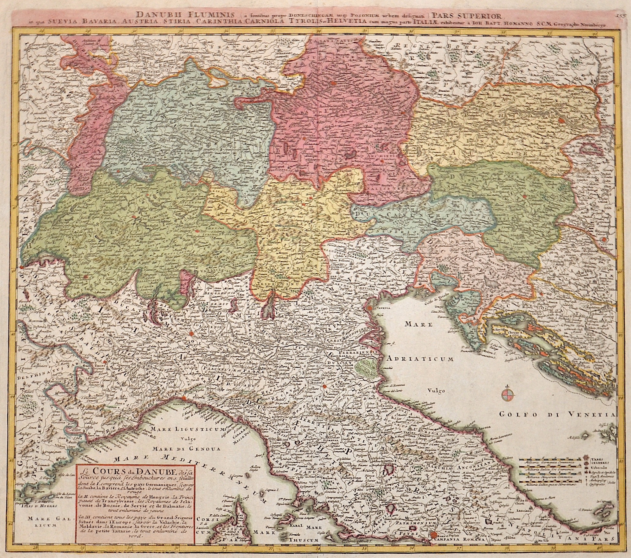
Danubii fluminis pars superior in qua Suevia , Bavaria, Austria, Stiria, Carinthia, Carniola, Tyrolis et Helvetia cum magna parte Italiae

| Article ID | EUX941 |
Title | Danubii fluminis pars superior in qua Suevia , Bavaria, Austria, Stiria, Carinthia, Carniola, Tyrolis et Helvetia cum magna parte Italiae |
Description | Map shows South Germany, Swizzerland, Austria and north Italy |
| Year | ca. 1710 |
Artist | Homann (1664-1724) |
Johann Babtiste Homann (1664-1724), Nuremberg, was born in Oberkammlach, the Electorate of Bavaria. Although educated at a Jesuit school, and preparing for an ecclesiastical career, he eventually converted to Protestantism and from 1687 worked as a civil law notary in Nuremberg. He soon turned to engraving and cartography; in 1702 he founded his own publishing house. Homann acquired renown as a leading German cartographer, and in 1715 was appointed Imperial Geographer by Emperor Charles VI. Giving such privileges to individuals was an added right that the Holy Roman Emperor enjoyed. In the same year he was also named a member of the Prussian Academy of Sciences in Berlin. Of particular significance to cartography were the imperial printing privileges (Latin: privilegia impressoria). These protected for a time the authors in all scientific fields such as printers, copper engravers, map makers and publishers. They were also very important as a recommendation for potential customers. In 1716 Homann published his masterpiece Grosser Atlas ueber die ganze Welt (Grand Atlas of all the World). Numerous maps were drawn up in cooperation with the engraver Christoph Weigel the Elder, who also published Siebmachers Wappenbuch. Homann died in Nuremberg. He was succeeded by the Homann heirs company, which was in business until 1848. The company was known as Homann Erben, Homanniani Heredes, or Heritiers de Homann abroad. | |
Historical Description | The Danube is the second largest and second longest river in Europe after the Volga. It flows through or touches ten countries (Germany, Austria, Slovakia, Hungary, Croatia, Serbia, Bulgaria, Romania, the Republic of Moldova and Ukraine) - more than any other river in the world. As early as the seventh century BC, Greeks who came from the Black Sea via the city of Tomis, now Constanța, sailed upstream. Their voyage of discovery ended at the Iron Gate, a rocky cataract section with many shallows, whose dangerous course made it impossible for the Greek ships to continue their journey via the Southern Carpathians and the Serbian Ore Mountains. Under the Romans, the Danube formed the border with the peoples to the north almost from its source to its mouth and also served as a transportation route for troops and to supply the settlements downstream. Charlemagne's route, which was used by Gottfried of Bouillon's army during the First Crusade between 1096 and 1099, also ran along the Danube from Regensburg to Belgrade. In 1529, the Turks reached Vienna (then the center of Central Europe) and besieged it, but were defeated. The Ottomans' expansion along the Danube was thus halted and from the second Battle of Mohács (1687) onwards, they lost land and power again. Alongside the Austrians, however, the Ottoman Empire remained the most important political factor in south-eastern Europe until the final loss of its Balkan territories through the Russo-Turkish Wars (1768-1774) and the Balkan Wars of 1912/13. The Danube was not only the main military and commercial artery, but also the political, cultural and religious border between the Orient and the Occident. In the peace treaty of Versailles after the First World War, the Danube was declared an international river in 1919 along with the Elbe, Memel and Oder. This internationalization of the waterway led to hopes arising in the Danube city of Regensburg in 1925 that the city could connect to the rapidly developing international air traffic. Flughafen GmbH Regensburg had a water landing site on the Danube near Winzer. At the time, seaplanes were seen as a promising technology for the short term and the Royal British Government was planning an airmail route with seaplanes across Europe to India with stopovers on the Danube. The plans came to nothing in 1926 / 27 after the rapid development of aviation technology. |
| Place of Publication | Nuremberg |
| Dimensions (cm) | 49 x 55 |
| Condition | Very good |
| Coloring | colored |
| Technique | Copper print |