

Adina Sommer
Antique and Contemporary Art
Winzerer Str. 154
80797 München
telephone
+49 89 304714
business hours:
by appointment
Email
![]()


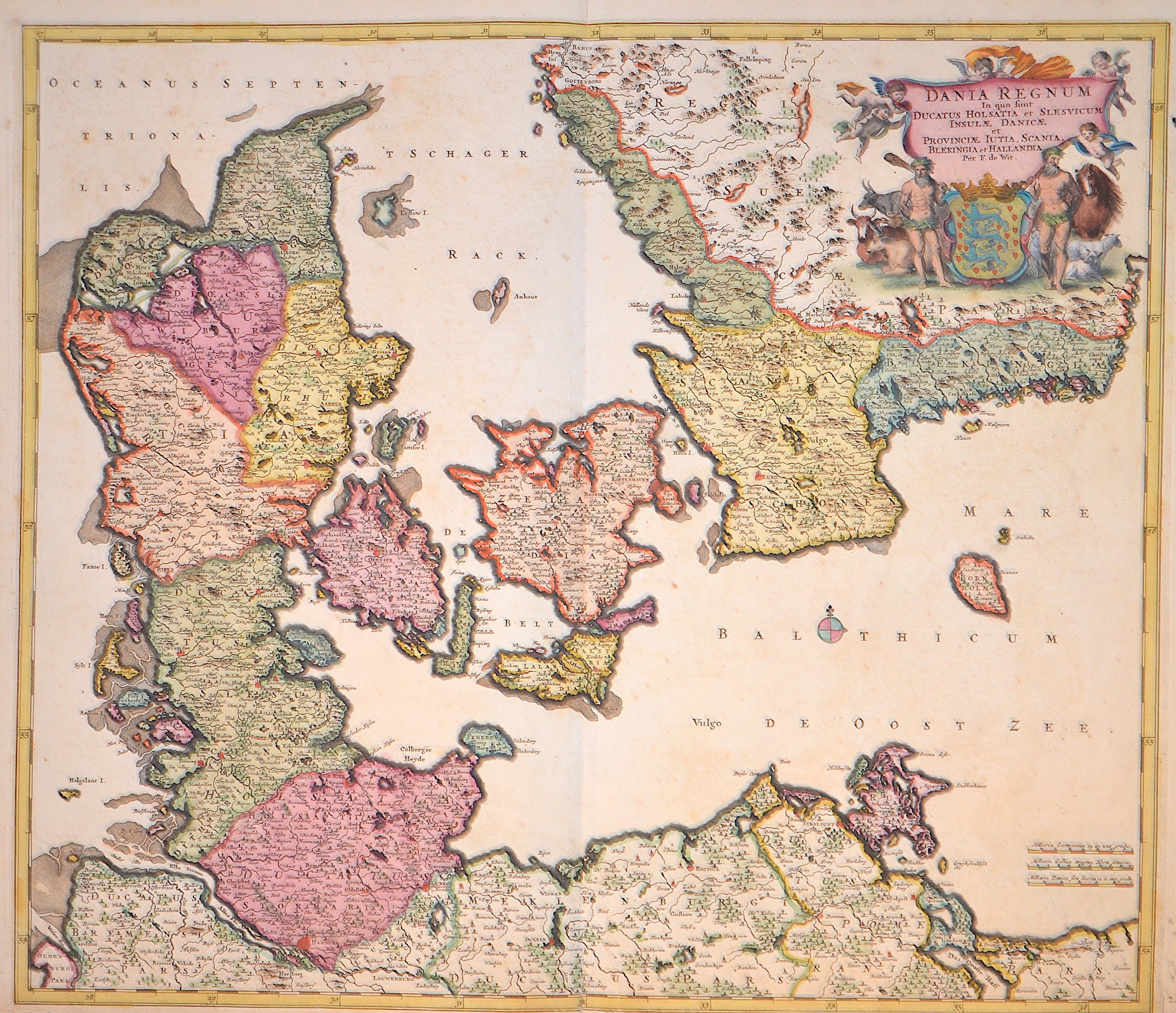
Dania regnum In quo sunt Ducatus Holsatia et Slesvicum Insulae Danicae et Provinciae Jutia, Scania, Blekingia et Hallandia

| Article ID | EUS630 |
Title | Dania regnum In quo sunt Ducatus Holsatia et Slesvicum Insulae Danicae et Provinciae Jutia, Scania, Blekingia et Hallandia |
Description | Map shows the whole of Denmark with title cartouche and coat of arms. |
| Year | ca. 1688 |
Artist | Wit, de (1610-1698) |
Frederik de Wit (1610 – 1698). His Atlas began to appear around 1662 and by 1671 included anywhere from 17 to 151 maps each. In the 1690s he began to use a new title page "Atlas Maior" but continued to use his old title page. His atlas of the Low Countries first published in 1667,was named Nieuw Kaertboeck van de XVII Nederlandse Provinciën and contained 14 to 25 maps. Frederik de Wit quickly expanded upon his first small folio atlas which contained mostly maps printed from plates that he had acquired, to an atlas with 27 maps engraved by or for him. By 1671 he was publishing a large folio atlas with as many as 100 maps. Smaller atlases of 17 or 27 or 51 maps could still be purchased and by the mid-1670s an atlas of as many as 151 maps and charts could be purchased from his shop. In ca.1675 Frederik de Wit released a new nautical atlas. The charts in this atlas replaced the earlier charts from 1664 that are known today in only four bound examples and a few loose copies. Frederik de Wit new charts were sold in a chart book and as part of his atlases. Frederik de Wit published no fewer than 158 land maps and 43 charts on separate folio sheets. In 1695 Frederik de Wit began to publish a town atlas of the Netherlands after he acquired a large number of city plans at the auction of the famous Blaeu publishing firm’s printing plates. Dating Frederik de Wit atlases is considered difficult because usually no dates were recorded on the maps and their dates of publication extended over many years. | |
Historical Description | Denmark is a country and sovereign state in Northern Europe and a parliamentary monarchy. Denmark is officially called the Kingdom of Denmark along with the Faroe Islands, which geographically belong to Northern Europe, like the mother country, and Greenland, which belongs to North America. The Danish people are said to have come from Scania to Jutland and the western Baltic islands in the 6th century, where they displaced other Germanic tribes. In the 10th century, Gorm the Old (around 950) united the individual minor kingdoms under his rule. Until 1035, when Knut the Great died, the Danish kings succeeded in conquering large parts of the British Isles. Until well into the 11th century, the Danes, Swedes and Norwegians, among others, were called Vikings, who founded colonies and traded throughout Europe. The only land border is between Denmark and Germany. A Danish minority lives in the former Danish southern Schleswig. With the Kalmar Union, Halland was suddenly in the center of the Danish Empire and, according to the Union Treaty, Erich of Pomerania should have been crowned in Halmstad. In the period that followed, Halland was not spared the wars of the era. In 1434, the landscape was conquered by the fighters of the Engelbrekt uprising and the Falkenberg castle was burned down. In the course of the Three Crown War, the Battle of Axtorna (also: Battle on the Falkenberger Haide) took place here in 1565, during which the Danish general Rantzau defeated a superior Swedish army. Until 1645 Halland belonged to Denmark and was then awarded in the peace of Brömsebro to Sweden for 30 years. Since the Peace of Roskilde in 1658, Halland has finally belonged to Sweden, although Denmark tried again in the Schoen War (1675–1679) to recapture lost territory. |
| Place of Publication | Amsterdam |
| Dimensions (cm) | 50 x 58 cm |
| Condition | Some restoration at lower centerfold |
| Coloring | original colored |
| Technique | Copper print |