

Adina Sommer
Antique and Contemporary Art
Winzerer Str. 154
80797 München
telephone
+49 89 304714
business hours:
by appointment
Email
![]()


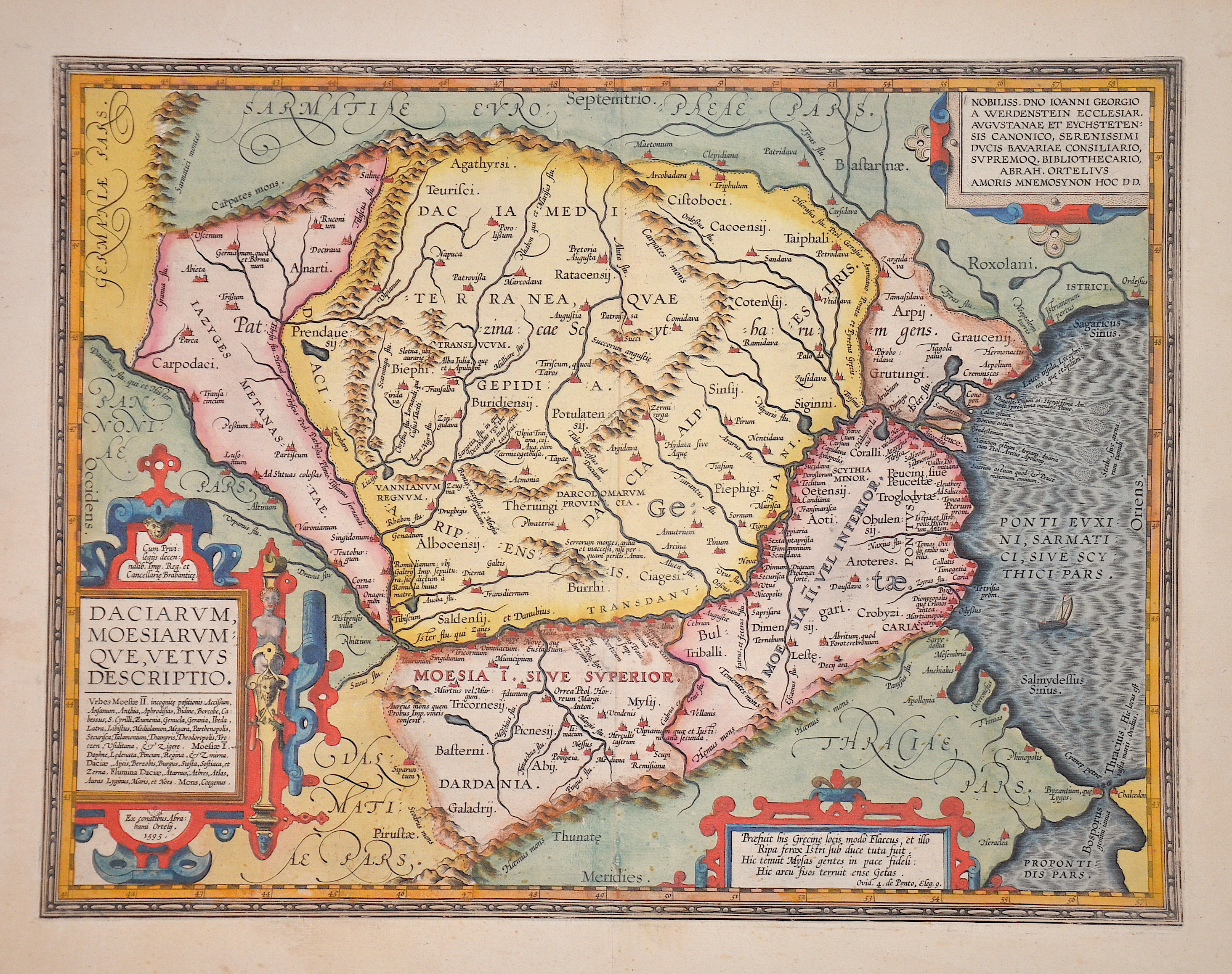
Daciarum, Moesiarum que, vetus descriptio.

| Article ID | EUR711 |
Title | Daciarum, Moesiarum que, vetus descriptio. |
Description | Map shows Romania with its neighboring countries and three cartouches. |
| Year | dated 1595 |
Artist | Ortelius (1527-1598) |
Abraham Ortelius (1527–1598) was a Flemish cartographer and publisher from Antwerp. Originally a map colorist, he became a major figure in cartography through his Theatrum Orbis Terrarum (1570), considered the first modern atlas—a uniform collection of reliable maps in book form. Influenced by Gerardus Mercator, Ortelius published several maps before compiling the Theatrum, which clearly showed America as a separate continent. The work was published in 42 editions and 7 languages by 1612. Unlike many of his peers, Ortelius cited his sources, and his atlas became a milestone in mapmaking and geographic knowledge. | |
Historical Description | Romania is a sovereign state located at the crossroads of Central, Eastern, and Southeastern Europe. It borders the Black Sea, Bulgaria, Ukraine, Hungary, Serbia, and Moldova. Modern Romania was formed in 1859 through a personal union of the Danubian Principalities of Moldavia and Wallachia. Prior to the Roman conquest of Dacia, the territories between the Danube and Dniester rivers were inhabited by various Thracian peoples, including the Dacians and the Getae. In the Middle Ages, Romanians lived in three principalities: Moldavia and in Transylvania. The existence of independent Romanian voivodeships in Transylvania as early as the 9th century is mentioned in Gesta Hungarorum[ but by the 11th century, Transylvania had become a largely autonomous part of the Kingdom of Hungary In the other parts, many small local states with varying degrees of independence developed, but only under Basarab I and Bogdan I the larger principalities of Wallachia and Moldaviawould emerge in the 14th century to fight the threat of the Ottoman Empire. By 1541, the entire Balkan peninsula and most of Hungary had been conquered and integrated into the Ottoman Empire. By contrast, Moldavia, Wallachia, and Transylvania, while under Ottoman suzerainty, preserved partial or full internal autonomy until the mid-19th century. In 1600, all three principalities were ruled simultaneously by the Wallachian prince Michael the Brave. During the period of the Austro-Hungarian rule in Transylvania and of Ottoman suzerainty over Wallachia and Moldavia, most Romanians were given few rights in a territory where they formed the majority of the population. Nationalistic themes became principal during the Wallachian uprising of 1821, and the 1848 revolutions in Wallachia and Moldavia. After the failed 1848 revolutions not all the Great Powers supported the Romanians' expressed desire to officially unite in a single state. But in the aftermath of the Crimean War, the electors in both Moldavia and Wallachia voted in 1859 for the same leader, Alexandru Ioan Cuza, as Domnitor and the two principalities became a personal unionformally under the suzerainty of the Ottoman Empire. Following a coup d'état in 1866, Cuza was exiled and replaced with Prince Carol I of Romania of the House of Hohenzollern-Sigmaringen. During the 1877–1878 Russo-Turkish War Romania fought on the Russian side and in the aftermath, it was recognized as an independent state both by the Ottoman Empire and the Great Powers by the Treaty of San Stefano and the Treaty of Berlin. The new Kingdom of Romania underwent a period of stability and progress until 1914, and also acquired Southern Dobruja from Bulgaria after the Second Balkan War. |
| Place of Publication | Antwerp |
| Dimensions (cm) | 35 x 45,5 cm |
| Condition | Perfect condition |
| Coloring | original colored |
| Technique | Copper print |