

Adina Sommer
Antique and Contemporary Art
Winzerer Str. 154
80797 München
telephone
+49 89 304714
business hours:
by appointment
Email
![]()


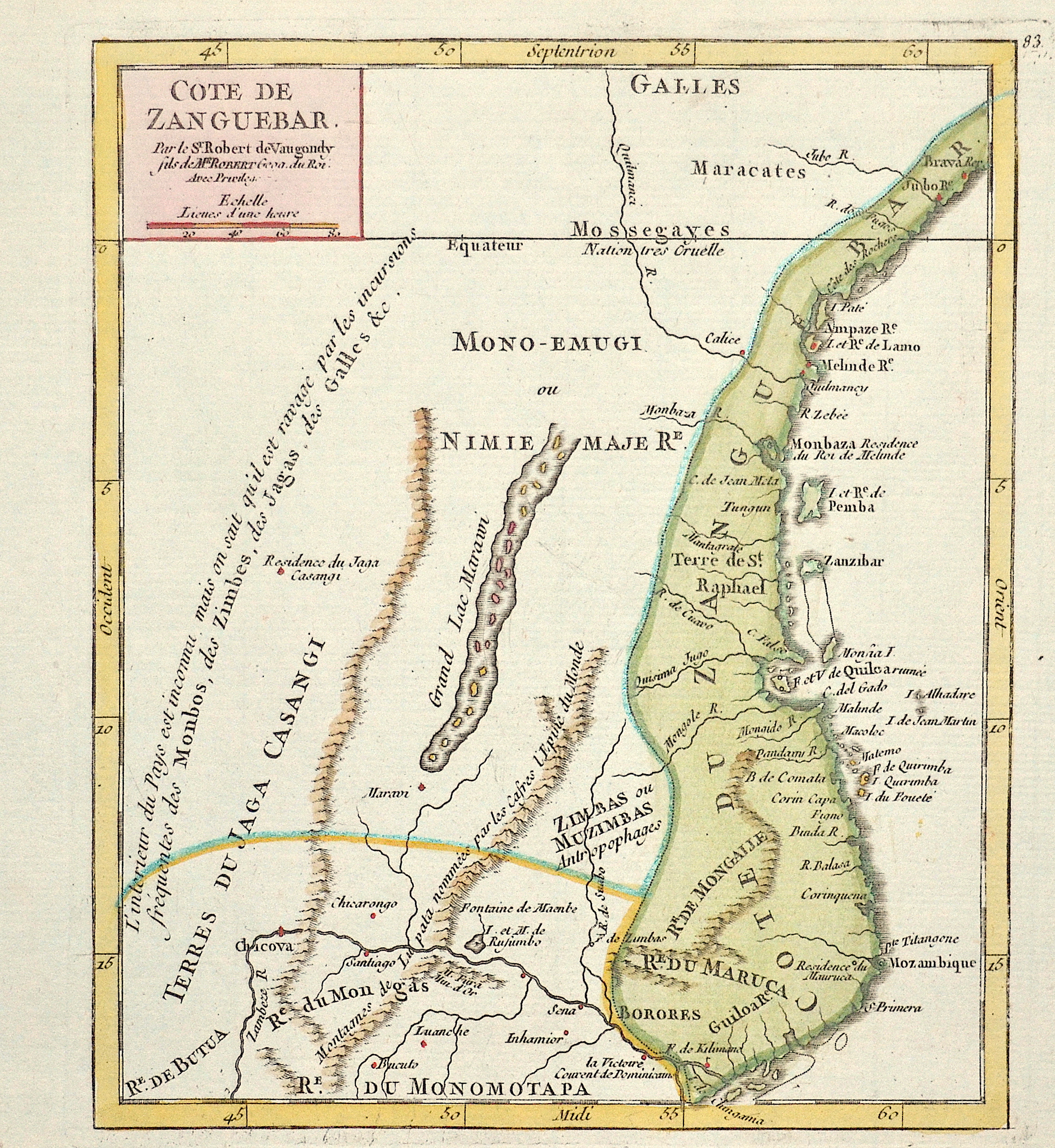
Cote de Zanguebar.

| Article ID | AF0480 |
Title | Cote de Zanguebar. |
Description | Map shows the east African coast of Kenya and Tanzania with the port city of Mombasa (located on Mombasa Island) and the island of Zanzibar (Tanzania). |
| Year | ca. 1760 |
Artist | Vaugondy,de (1723-1786) |
Didier Robert de Vaugondy (1723 -1786) also known as Le Sieur or Monsieur Robert, and his son, were leading cartographers in France during the 18th century. In 1757, Gilles and Didier Robert De Vaugondy published The Atlas Universel, one of the most important atlases of the 18th century. To produce the atlas, the Vaugondys integrated older sources with more modern surveyed maps. They verified and corrected the latitude and longitude of many regional maps in the atlas with astronomical observations. The older material was revised with the addition of many new place names. In 1760, Didier Robert de Vaugondy was appointed geographer to Louis XV. Gilles and Didier Robert De Vaugondy produced their maps and terrestrial globes working together as father and son. Globes of a variety of sizes were made by gluing copperplate-printed gores on a plaster-finished papier-mache core, a complicated and expensive manufacturing process, employing several specialists. In some cases it is uncertain whether Gilles or Didier made a given map. Gilles often signed maps as M.Robert, while Didier commonly signed his maps as ""Robert de Vaugondy"", or added ""fils"" or ""filio"" after his name. The Robert de Vaugondys were descended from the Nicolas Sanson family through Sanson's grandson, Pierre Moulard-Sanson. From him, they inherited much of Sanson's cartographic material, which they combined with maps and plates acquired after Hubert Jaillot's death in 1712 to form the basis the Atlas Universel. | |
Historical Description | Before the great exploratory trips by the Europeans, Arabs had ruled the coast off Africa for centuries. They traded between Africa, the Orient and India in gold, ivory and African slaves. The first Portuguese to land in Sofala in 1497 was Pedro da Covilhã, who was commissioned by the Portuguese king to explore the sea route from Arabia to East Africa. In 1498 Vasco da Gama reached Mozambique on the way to India: On the island of Mozambique he met Sheikh Moussa Ben Mbiki, from whom the name Mozambique is derived. The Portuguese then seized these trading centers and penetrated inland along the Zambezi in search of gold. For centuries the Portuguese were content with trading slaves and cared little about the population. Their rule lasted into the 20th century, and living conditions in the colonies deteriorated considerably as a result of forced labor, exploitative employment contracts and reckless treatment. Until 1898, the city of Ilha de Moçambique was the country's capital. She also gave the country its name. |
| Place of Publication | Paris |
| Dimensions (cm) | 19 x 16 cm |
| Condition | Perfect condition |
| Coloring | original colored |
| Technique | Copper print |