

Adina Sommer
Antique and Contemporary Art
Winzerer Str. 154
80797 München
telephone
+49 89 304714
business hours:
by appointment
Email
![]()


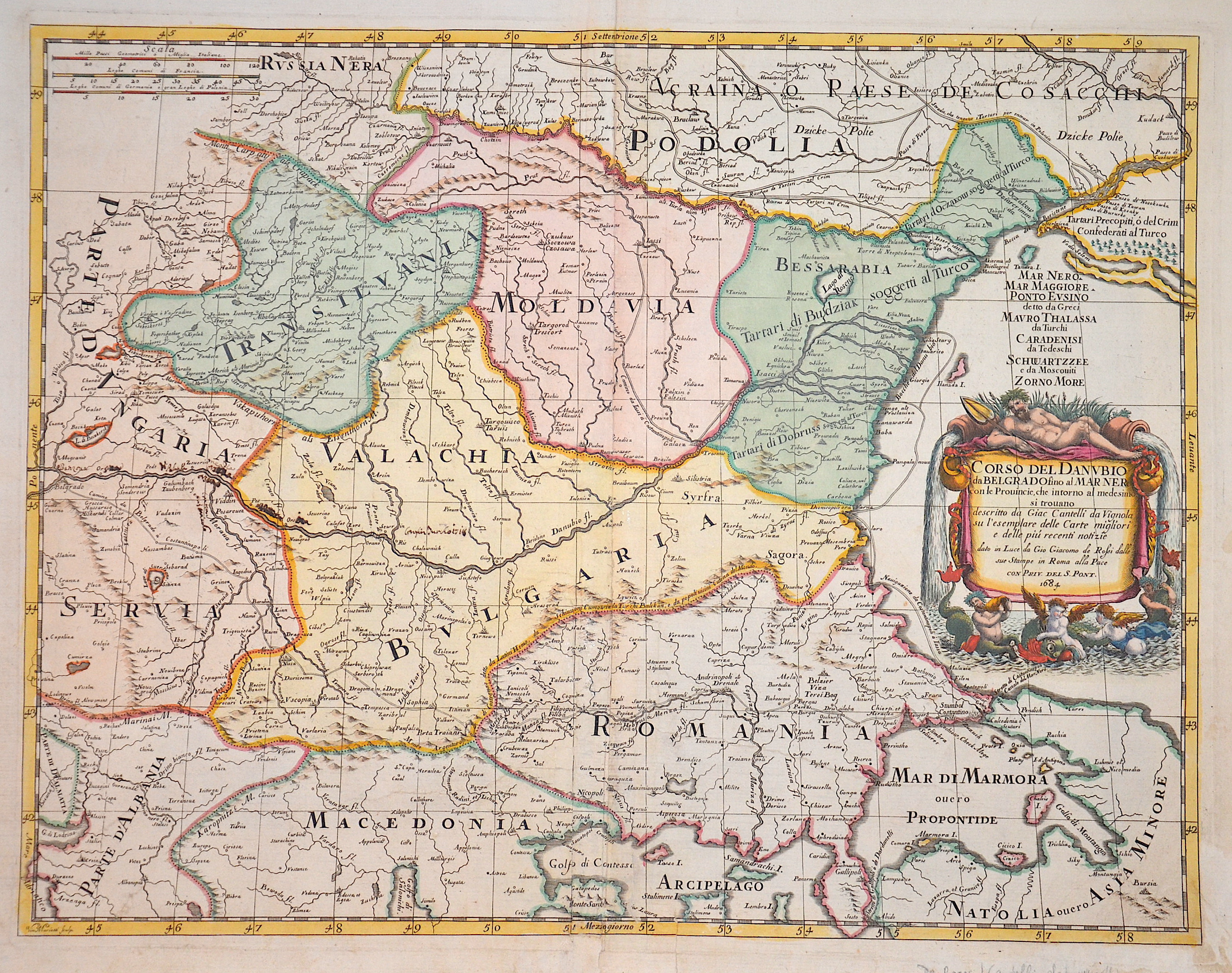
Corso dell Danubio da Belgrado fino al marnero

| Article ID | EUR559 |
Title | Corso dell Danubio da Belgrado fino al marnero |
Description | Map shows the Balkan with Romania and the Danube |
| Year | dated 1684 |
Artist | Cantelli da Vignola (1643-1695) |
Giacomo Cantelli (1643–1695) studied literature in Bologna and later became secretary to the Marquis of Ferrara, Obizzi. He moved to Venice, where he gained recognition as a geographer, and likely traveled to Paris as part of a Venetian diplomatic mission to the court of Louis XIV. In Paris, he connected with cartographers such as Guillaume Sanson, Jacques-André Duval, and Michel-Antoine Baudrand. After returning to Italy, he served as secretary to Count Rinieri Marescotti in Bologna and traveled extensively, including to Rome, where he met publisher Giovanni Giacomo De Rossi. In 1672, De Rossi began publishing Cantelli’s maps, starting with the Holy Land, the Kingdom of Persia, and regions of the Ottoman Empire. In 1680–1681, Cantelli’s maps of Upper and Lower Lombardy appeared in the Mercury Geographic Atlas in Rome, showing strong influence from Giovanni Antonio Magini’s cartographic style. | |
Historical Description | Romania is a sovereign state located at the crossroads of Central, Eastern, and Southeastern Europe. It borders the Black Sea, Bulgaria, Ukraine, Hungary, Serbia, and Moldova. Modern Romania was formed in 1859 through a personal union of the Danubian Principalities of Moldavia and Wallachia. Prior to the Roman conquest of Dacia, the territories between the Danube and Dniester rivers were inhabited by various Thracian peoples, including the Dacians and the Getae. In the Middle Ages, Romanians lived in three principalities: Moldavia and in Transylvania. The existence of independent Romanian voivodeships in Transylvania as early as the 9th century is mentioned in Gesta Hungarorum[ but by the 11th century, Transylvania had become a largely autonomous part of the Kingdom of Hungary In the other parts, many small local states with varying degrees of independence developed, but only under Basarab I and Bogdan I the larger principalities of Wallachia and Moldaviawould emerge in the 14th century to fight the threat of the Ottoman Empire. By 1541, the entire Balkan peninsula and most of Hungary had been conquered and integrated into the Ottoman Empire. By contrast, Moldavia, Wallachia, and Transylvania, while under Ottoman suzerainty, preserved partial or full internal autonomy until the mid-19th century. In 1600, all three principalities were ruled simultaneously by the Wallachian prince Michael the Brave. During the period of the Austro-Hungarian rule in Transylvania and of Ottoman suzerainty over Wallachia and Moldavia, most Romanians were given few rights in a territory where they formed the majority of the population. Nationalistic themes became principal during the Wallachian uprising of 1821, and the 1848 revolutions in Wallachia and Moldavia. After the failed 1848 revolutions not all the Great Powers supported the Romanians' expressed desire to officially unite in a single state. But in the aftermath of the Crimean War, the electors in both Moldavia and Wallachia voted in 1859 for the same leader, Alexandru Ioan Cuza, as Domnitor and the two principalities became a personal unionformally under the suzerainty of the Ottoman Empire. Following a coup d'état in 1866, Cuza was exiled and replaced with Prince Carol I of Romania of the House of Hohenzollern-Sigmaringen. During the 1877–1878 Russo-Turkish War Romania fought on the Russian side and in the aftermath, it was recognized as an independent state both by the Ottoman Empire and the Great Powers by the Treaty of San Stefano and the Treaty of Berlin. The new Kingdom of Romania underwent a period of stability and progress until 1914, and also acquired Southern Dobruja from Bulgaria after the Second Balkan War. |
| Place of Publication | Rome |
| Dimensions (cm) | 42 x 54 |
| Condition | Centerfold perfetly restored |
| Coloring | original colored |
| Technique | Copper print |