

Adina Sommer
Antique and Contemporary Art
Winzerer Str. 154
80797 München
telephone
+49 89 304714
business hours:
by appointment
Email
![]()


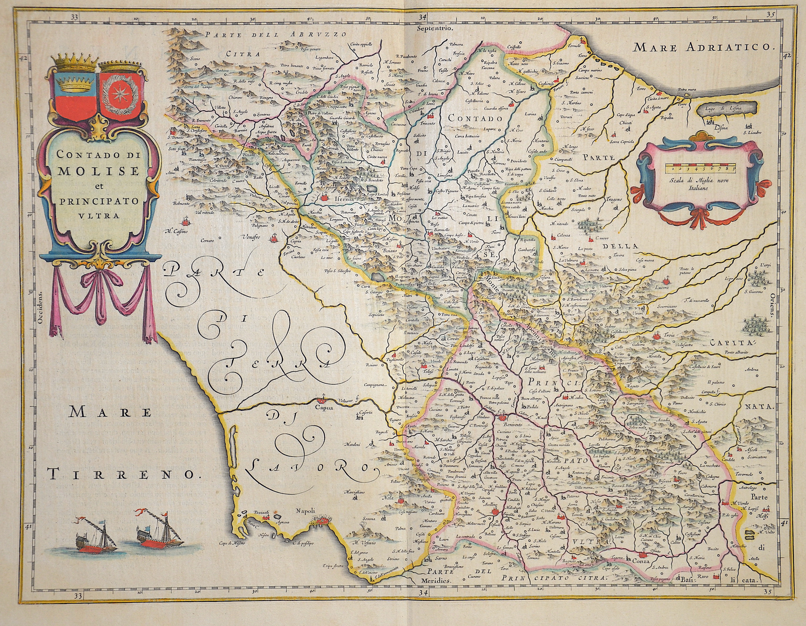
Contado di Molise et Principato ultra”

| Article ID | EUI0395 |
Title | Contado di Molise et Principato ultra” |
Description | Map of Molise and the Campania with two splendid cartouches, a title cartouche with depictions of coats of arms, a mileage scale and two sailing ships. |
| Year | ca. 1640 |
Artist | Blaeu (1571-1638) |
Joan Guilliemus Blaeu was the eldest son of Willem Janszoon Blaeu (1571-1638), and was probably born in Alkmaar in the province of Noord-Holland in the final years of the 16th century. He was brought up in Amsterdam, and studied law at the University of Leiden before going into partnership with his father in the 1630s. Although his father Willem had cartographic interests, having studied under the Danish astronomer Tycho Brahe and having manufactured globes and instruments, his primary business was as a printer. It was under the control of Joan that the Blaeu printing press achieved lasting fame by moving towards the printing of maps and expanding to become the largest printing press in Europe in the 17th century. By the 1660s the Theatrum Orbis Terrarum (or Atlas Maior as it had became known by this time) had expanded to between 9 and 12 volumes, depending on the language. With over 3,000 text pages and approximately 600 maps, it was the most expensive book money could buy in the later 17th century. The translation of the text from Latin into Dutch, English, German, French, and Spanish for several volumes created enormous work for those involved in typography and letterpress activities. It is estimated that over 80 men must have been employed full-time in the Blaeu printing house in Bloemgracht, not including engravers who worked elsewhere, with over 15 printing presses running simultaneously, and in 1667 a second press was acquired at Gravenstraat. At the same time as producing the Atlas Maior, Blaeu was also publishing town plans of Italy, maps for globes, and other volumes. At its peak the Blaeu press managed to produce over 1 million impressions from 1,000 copper plates within four years. | |
Historical Description | Central Italy is the central section of the Italy peninsula, which is divided into northern Italy, central Italy and southern Italy. It stretches from the Apennine ridge between La Spezia and Rimini to the historic northern border of the Kingdom of Naples. The southern boundary today runs along the rivers Tronto and Garigliano after changes in the provinces in the 1920s. Central Italy is formed by the regions of Tuscany, Umbria, Marche and Lazio, whereby only Tuscany can be linguistically and culturally uniformly classified as Central Italy. Within these borders, central Italy also forms one of the five Italian macro regions. In ancient times, in northern Italy, unlike in southern Italy, there was hardly any Greek colonization. For the Roman Empire, Northern Italy was initially Gallia cisalpina. Since the Middle Ages, northern Italy has been characterized by remarkable trading cities, which, starting from the Veronese Confederation, united in the Lombardenbund against Emperor Barbarossa. The history of Italy, documented by written sources, begins only after the settlement by Italian peoples. Alongside them, the culture of the Etruscans, whose origin is unknown, was experienced around 600 BC. Their heyday. In the 8th century BC The Greek colonization of the southern Italian mainland and Sicily had begun, and Phoenicians settled on the west coast of the island. These colonies later belonged to Carthage. From the 4th century BC began the expansion of Rome. From the 5th century Italy came under the rule of Germanic tribes, the population declined drastically until around 650, and Ostrom briefly conquered the former core area of the empire in the 6th century. In the 8th century, the north, ruled by the Lombards for about two centuries, was annexed to the Franconian Empire, later to the Holy Roman Empire, while Arabs and Byzantines ruled in the south from the 11th century onwards. In most regions, feudalism prevailed in the early Middle Ages. The northern Italian municipalities, which came together in the Lombardenbund, were able to free themselves from the influence of the empire in the 12th and 13th centuries and establish their own territories. Of this multitude of territories, the most important were Milan, the sea powers Genoa and Venice, Florence and Rome, and the south of Italy, which was partly French and partly Spanish. After four centuries of fragmentation and foreign rule, the peninsula became politically united in the course of the Risorgimento national movement. The modern Italian state was founded in 1861. |
| Place of Publication | Amsterdam |
| Dimensions (cm) | 38 x 50 cm |
| Condition | Perfect condition |
| Coloring | original colored |
| Technique | Copper print |