

Adina Sommer
Antique and Contemporary Art
Winzerer Str. 154
80797 München
telephone
+49 89 304714
business hours:
by appointment
Email
![]()


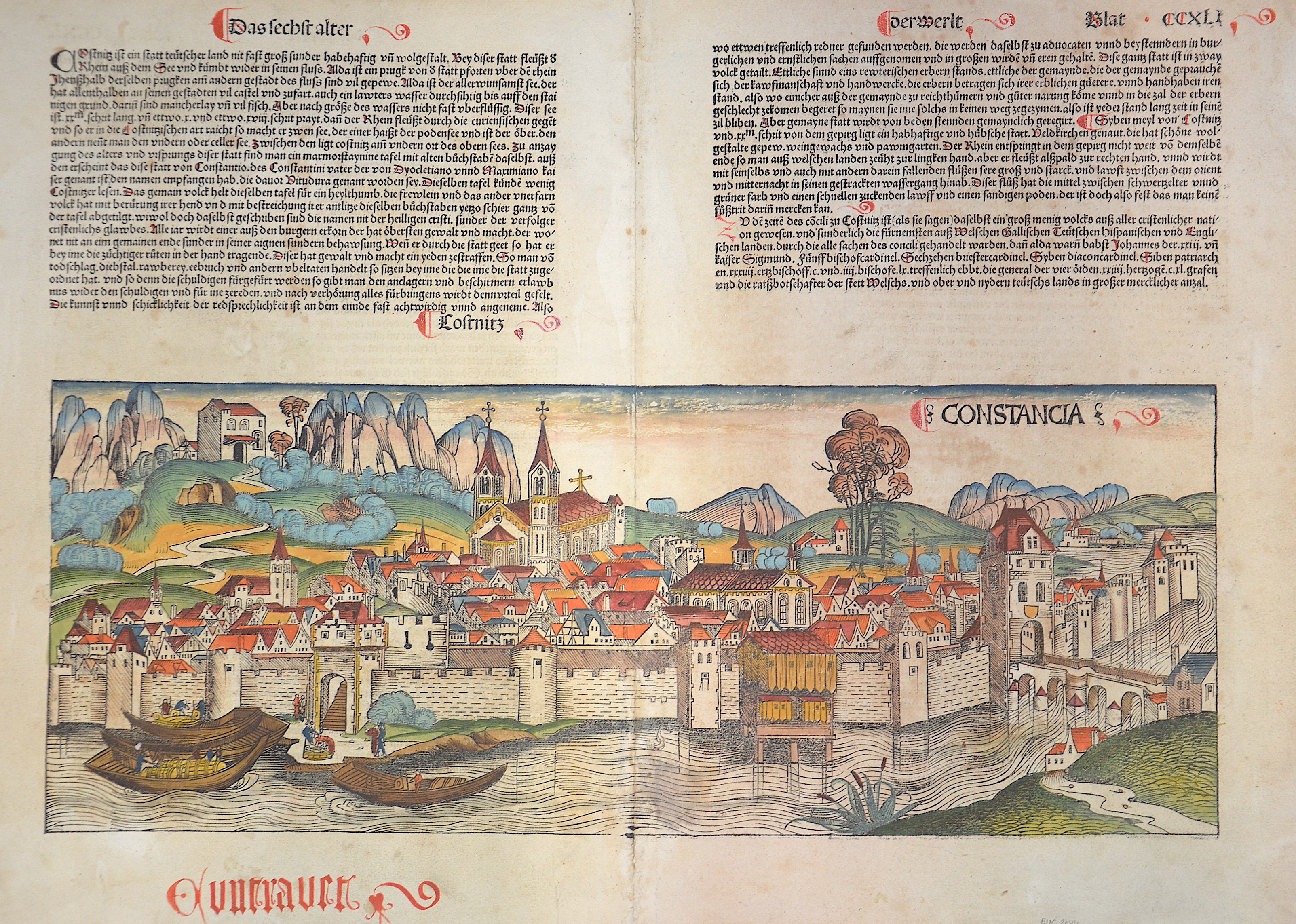
Constancia / Kosnitz

| Article ID | EUD2144 |
Title | Constancia / Kosnitz |
Description | Map shows the city of Constanz at the Bodensee, on riverse portraits of kings, dukes and bishops. |
| Year | ca. 1495 |
Artist | Schedel (1440-1515) |
Hartmann Schedel (1440–1515) from Nuremberg is best known for the 1493 publication of the Schedel’s World Chronicle (Liber chronicarum), a universal history featuring 1,809 woodcuts—making it the most richly illustrated book of early printing. The chronicle, written in Latin by Schedel for merchants Sebald Schreyer and Sebastian Kammermeister, was translated into German by Georg Alt and printed by Anton Koberger. The illustrations came from the workshop of Michael Wolgemut and Wilhelm Pleydenwurff. The work covers world history up to 1492/93, divided into eight ages of the world, and draws on numerous sources, including Jacobus Foresta and Enea Silvio Piccolomini. Notably, it features highly accurate city views, many depicted in detail for the first time. Pleydenwurff introduced a new perspective by portraying cities from a fixed viewpoint, emphasizing their unique architectural and landscape features. The project was funded in part by the patron Sebald Schreyer. | |
Historical Description | Baden-Wuertemberg is a state in southwest Germany, east of the Rhine, which forms the border with France. It is is formed from the historical territories of Baden, Prussian Hohenzollern, and Württemberg, and also parts of Swabia. Baden Würtemberg was only founded in 1952 by the merger of the states of Württemberg-Baden, Baden and Württemberg-Hohenzollern. Today the most populous city of Baden-Württemberg is the state capital Stuttgart, followed by Karlsruhe and Mannheim. Other major cities are Freiburg im Breisgau, Heidelberg, Ulm, Heilbronn, Pforzheim and Reutlingen. The early modern period was marked by the Reformation and the expansion efforts of the emerging states of Austria, Prussia, France and Sweden. Conflicts such as the Peasant War, the Thirty Years' War and the Palatinate War of Succession resulted from these. One of the focal points of the fighting, with corresponding consequences for the population and the economy, was in what is today Baden-Württemberg, which remained extremely fragmented territorially. At the beginning of the 19th century, around 300 states still had territorial rights in what is now Baden-Württemberg, but their number was reduced to four after the dissolution of the Old Empire. The Kingdom of Württemberg and the Grand Duchy of Baden were among the winners of the coalition wars. The two principalities of Hohenzollern-Sigmaringen and Hohenzollern-Hechingen survived mediatization due to their special relationship with Napoléon. In 1849, the Baden Revolution was put down by Prussian intervention forces, the Baden army was dissolved and rebuilt under Prussian leadership. In 1850 the two Hohenzollern states became the Prussian province of Hohenzollernsche Lande. With the new formation of the tribal duchies, the southern areas of what is now the state of Baden-Württemberg belonged to the Duchy of Swabia until the end of the High Middle Ages, the northern areas were located with the Duchy of Franconia. |
| Place of Publication | Nuremberg |
| Dimensions (cm) | 37 x 52 cm |
| Condition | Some restoration at centerfold |
| Coloring | original colored |
| Technique | Woodcut |