

Adina Sommer
Antique and Contemporary Art
Winzerer Str. 154
80797 München
telephone
+49 89 304714
business hours:
by appointment
Email
![]()


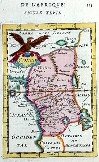
Congo

| Article ID | AF0138 |
Title | Congo |
Description | Map shows Congo with Kamerun and Gabun and its neighbour countries with the islands of Fernando - Poo and Sao Tome |
| Year | ca. 1683 |
Artist | Mallet (1630-1706) |
Alain Manesson Mallet (1630- 1706 ) was a French cartographer and engineer. He started his career as a soldier in the army of Louis XIV, became a Sergeant-Major in the artillery and an Inspector of Fortifications. He also served under the King of Portugal, before returning to France, and his appointment to the court of Louis XIV. His military engineering and mathematical background led to his position teaching mathematics at court. His major publications were Description de L'Univers (1683) in 5 volumes, and Les Travaux de Mars ou l'Art de la Guerre (1684) in 3 volumes. His Description de L'Universe contains a wide variety of information, including star maps, maps of the ancient and modern world, and a synopsis of the customs, religion and government of the many nations included in his text. It has been suggested that his background as a teacher led to his being concerned with entertaining his readers. This concern manifested itself in the charming harbor scenes and rural landscapes that he included beneath his description of astronomical concepts and diagrams. Mallet himself drew most of the figures that were engraved for this book. | |
Historical Description | The indigenous population of today's state consisted of pygmies, who are now only a small minority. Bantu peoples immigrated for centuries. Among the states there, the Kingdom of the Congo, founded in the 14th century and one of the largest African states ever, emerged. In the 15th century, Portuguese sailors around Diogo Cão explored the area of the Congo estuary and established diplomatic relations with the Congo Empire in 1491. From the 16th century onwards, the Congo Empire was in decline. By the end of the 17th century, the kingdom was completely destroyed, as well as being exploited and looted by slave hunters. After this collapse, the Portuguese supremacy was replaced by that of the Dutch and British. At the beginning of the 18th century the Congo Empire had almost completely disintegrated. In 1866 the last Portuguese left. In the 1870s, Henry Morton Stanley from Welsh was the first European to travel to the hinterland. He proposed that the Congo be incorporated into the British colonial empire. The British government refused because it was primarily interested in the sources of the Nile. The Democratic Republic of the Congo was originally administered as the Belgian Congo by a legislative assembly and regional assemblies made up of only Europeans appointed by colonial authorities. By the late 1950s there was a greater turnout of Africans, but not full voting rights until independence when the colony was renamed Zaire. With the global striving for independence in the colonies, the pressure for state self-determination also grew in the Congo. After the first unrest in the capital Léopoldville and under pressure from the global public, Belgium suddenly withdrew from the Congo in early 1959, leaving behind a chaos. In 1960 the Congo gained independence. |
| Place of Publication | Paris |
| Dimensions (cm) | 16,5 x 10 |
| Condition | Very good |
| Coloring | original colored |
| Technique | Copper print |