

Adina Sommer
Antique and Contemporary Art
Winzerer Str. 154
80797 München
telephone
+49 89 304714
business hours:
by appointment
Email
![]()


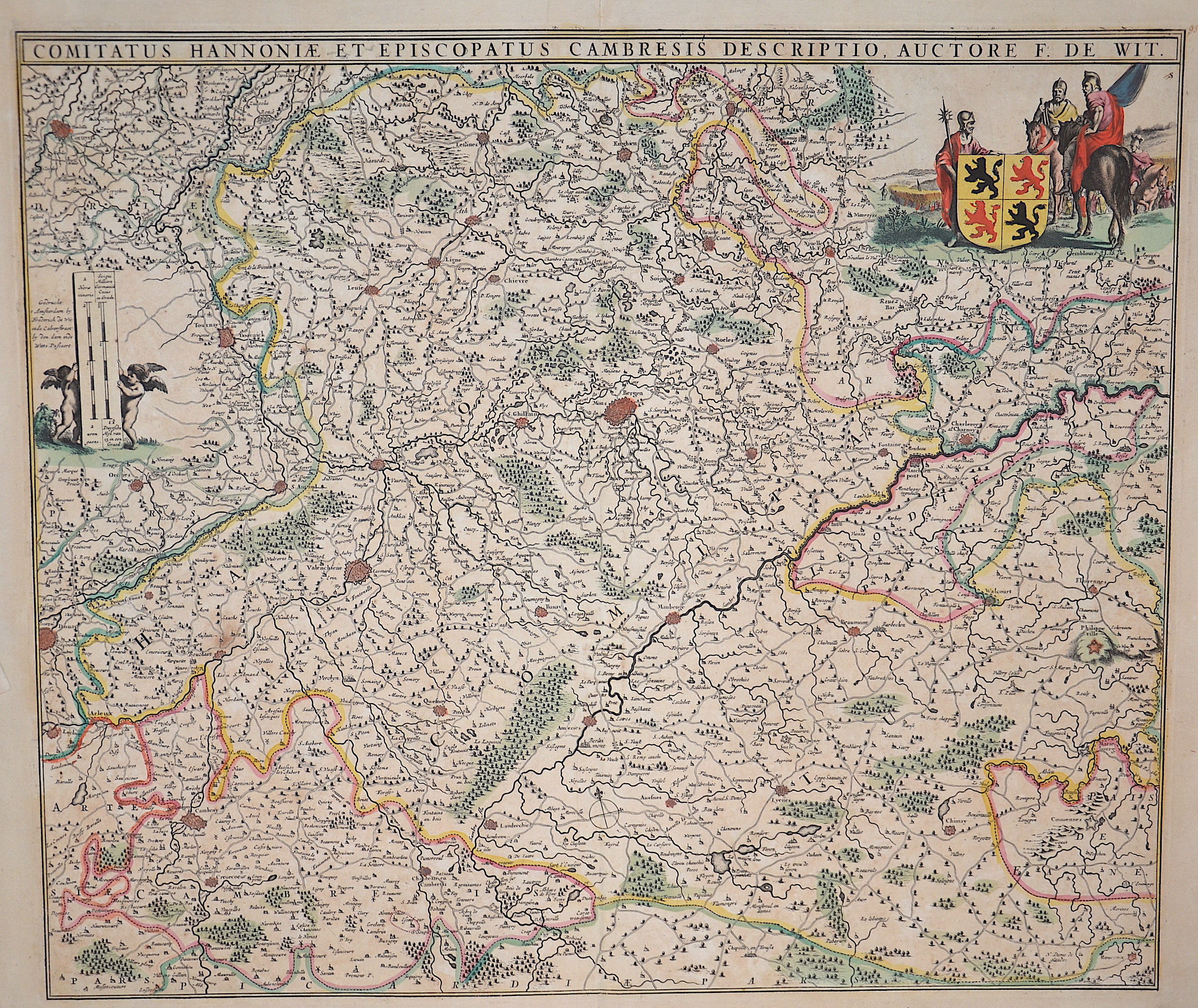
Comitatus Hannoniae et episcopatus Cambresis descriptio, Auctore F. de Wit.

| Article ID | EUB4827 |
Title | Comitatus Hannoniae et episcopatus Cambresis descriptio, Auctore F. de Wit. |
Description | Map shows the province of Hainaut in Belgium (partly France) with the city of Mons, Tournai, Ath, Charleroi, Walcourt, Maubeuge, Aymries, Dour, Valenciennes, La Cateau-Cambrésis and many more. Furthermore, on the upper right a cartouche with warriors and the coat of arms of Hainaut, on the left a mileage scale held by two putti. |
| Year | ca. 1670 |
Artist | Wit, de (1610-1698) |
Frederik de Wit (1610 – 1698). His Atlas began to appear around 1662 and by 1671 included anywhere from 17 to 151 maps each. In the 1690s he began to use a new title page "Atlas Maior" but continued to use his old title page. His atlas of the Low Countries first published in 1667,was named Nieuw Kaertboeck van de XVII Nederlandse Provinciën and contained 14 to 25 maps. Frederik de Wit quickly expanded upon his first small folio atlas which contained mostly maps printed from plates that he had acquired, to an atlas with 27 maps engraved by or for him. By 1671 he was publishing a large folio atlas with as many as 100 maps. Smaller atlases of 17 or 27 or 51 maps could still be purchased and by the mid-1670s an atlas of as many as 151 maps and charts could be purchased from his shop. In ca.1675 Frederik de Wit released a new nautical atlas. The charts in this atlas replaced the earlier charts from 1664 that are known today in only four bound examples and a few loose copies. Frederik de Wit new charts were sold in a chart book and as part of his atlases. Frederik de Wit published no fewer than 158 land maps and 43 charts on separate folio sheets. In 1695 Frederik de Wit began to publish a town atlas of the Netherlands after he acquired a large number of city plans at the auction of the famous Blaeu publishing firm’s printing plates. Dating Frederik de Wit atlases is considered difficult because usually no dates were recorded on the maps and their dates of publication extended over many years. | |
Historical Description | As the province of Belgica - a name introduced by Caesar - what is now Belgium experienced many rulers. From the High Middle Ages to the early modern period, the cities of Flanders with their cloth industries represented one of the two centers of the European economy. Politically, the individual territories came under the House of Burgundy, which was inherited by the Habsburgs in 1477. In 1579 the Catholic Union of Arras and the Calvinist-Protestant Union of Utrecht were formed. The provinces of the Union of Utrecht broke away from Spain in 1581 and founded the Republic of the Seven United Provinces, whose independence was recognized in the Peace of Westphalia of 1648 after the end of the Eighty Years War. The provinces of the Union of Arras, Flanders and Brabant were administered as the Spanish Netherlands by a Spanish governor. After the extinction of the Spanish Habsburgs (1700) and the resulting War of the Spanish Succession, the Austrian Netherlands came under the rule of the Austrian Habsburgs in 1714. As a result of the absolutist-centralistic efforts of the Austrian ruler Joseph II, the Brabant Revolution came in 1789 and the short-lived United Belgian States. Revolutionary France annexed the Austrian Netherlands between 1792 and 1794, followed by incorporation into the French Republic in 1795. At the Congress of Vienna (1815) the provinces were awarded to the Netherlands. After the Belgian Revolution, the country gained independence in 1830. |
| Place of Publication | Amsterdam |
| Dimensions (cm) | 47 x 55 cm |
| Condition | Perfect condition |
| Coloring | original colored |
| Technique | Copper print |