

Adina Sommer
Antique and Contemporary Art
Winzerer Str. 154
80797 München
telephone
+49 89 304714
business hours:
by appointment
Email
![]()


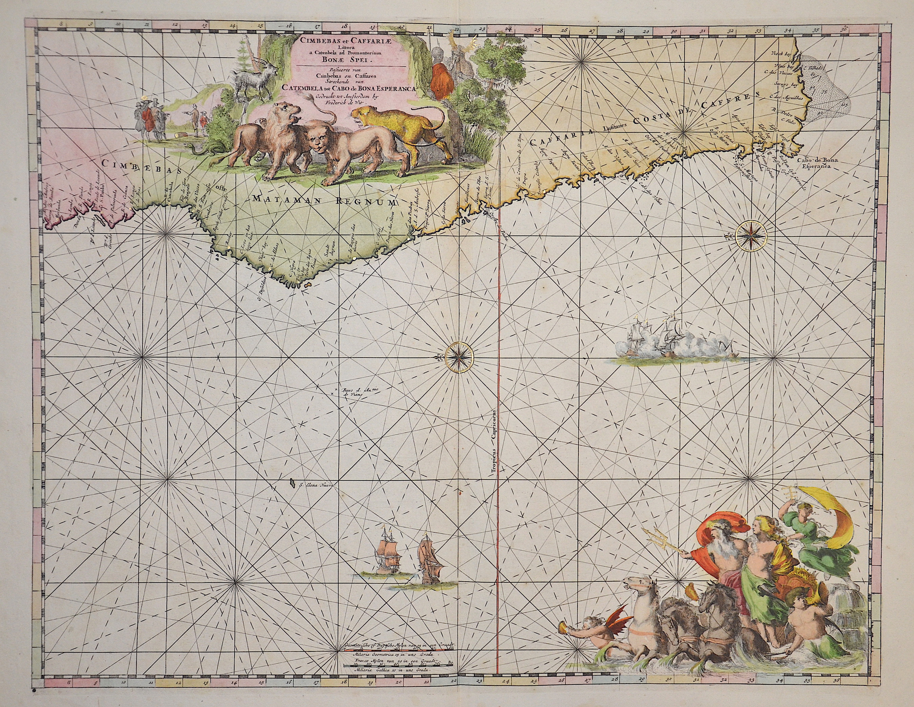
Cimbebas et Caffariae Littora a Catembela ad Promontorium Boan Spei..

| Article ID | SE0290 |
Title | Cimbebas et Caffariae Littora a Catembela ad Promontorium Boan Spei.. |
Description | Map shows the Atlatic with the western coast of Africa |
| Year | ca. 1675 |
Artist | Wit, de (1610-1698) |
Frederik de Wit (1610 – 1698). His Atlas began to appear around 1662 and by 1671 included anywhere from 17 to 151 maps each. In the 1690s he began to use a new title page "Atlas Maior" but continued to use his old title page. His atlas of the Low Countries first published in 1667,was named Nieuw Kaertboeck van de XVII Nederlandse Provinciën and contained 14 to 25 maps. Frederik de Wit quickly expanded upon his first small folio atlas which contained mostly maps printed from plates that he had acquired, to an atlas with 27 maps engraved by or for him. By 1671 he was publishing a large folio atlas with as many as 100 maps. Smaller atlases of 17 or 27 or 51 maps could still be purchased and by the mid-1670s an atlas of as many as 151 maps and charts could be purchased from his shop. In ca.1675 Frederik de Wit released a new nautical atlas. The charts in this atlas replaced the earlier charts from 1664 that are known today in only four bound examples and a few loose copies. Frederik de Wit new charts were sold in a chart book and as part of his atlases. Frederik de Wit published no fewer than 158 land maps and 43 charts on separate folio sheets. In 1695 Frederik de Wit began to publish a town atlas of the Netherlands after he acquired a large number of city plans at the auction of the famous Blaeu publishing firm’s printing plates. Dating Frederik de Wit atlases is considered difficult because usually no dates were recorded on the maps and their dates of publication extended over many years. | |
Historical Description | For a long time in human history, the Atlantic was the great body of water that separated the "Old World" from the "New World." Covering an area of about 106 million square kilometers, the Atlantic Ocean makes up roughly one-fifth of the Earth's surface. Due to its vast size, the Atlantic is commonly divided into the North Atlantic and the South Atlantic. In the 17th century, the Atlantic Ocean was a central stage for global trade, colonialism, and naval power politics among the European powers. European countries such as Spain, Portugal, England, France, and the Netherlands used the Atlantic for their colonial ventures. The Americas, West Africa, and the Caribbean were interconnected through the Atlantic—economically, politically, and militarily. The transatlantic triangular trade flourished: European goods were brought to Africa, exchanged for enslaved people, who were then shipped to the Americas. From there, raw materials such as sugar, tobacco, or cotton were transported back to Europe. Thus, the Atlantic was also a major zone of intensive slave trade. The Atlantic routes were dangerous: in addition to natural hazards, there were also pirates and conflicts between rival colonial powers. By around 1680, the Atlantic had become the backbone of the emerging global economic system—shaped by colonialism, the slave trade, and naval power. It connected continents, but also spread violence, exploitation, and power struggles. After Christopher Columbus's first crossing in 1492, regular ocean crossings did not begin until the 19th century. People in Europe wanted to leave behind the poor living conditions of the time and start a new life in the rapidly developing Americas. This led to large waves of emigration.The first transatlantic steamship set sail from Bremerhaven on July 2, 1847. |
| Place of Publication | Amsterdam |
| Dimensions (cm) | 42,5 x 55 |
| Condition | Very good |
| Coloring | original colored |
| Technique | Copper print |