

Adina Sommer
Antique and Contemporary Art
Winzerer Str. 154
80797 München
telephone
+49 89 304714
business hours:
by appointment
Email
![]()


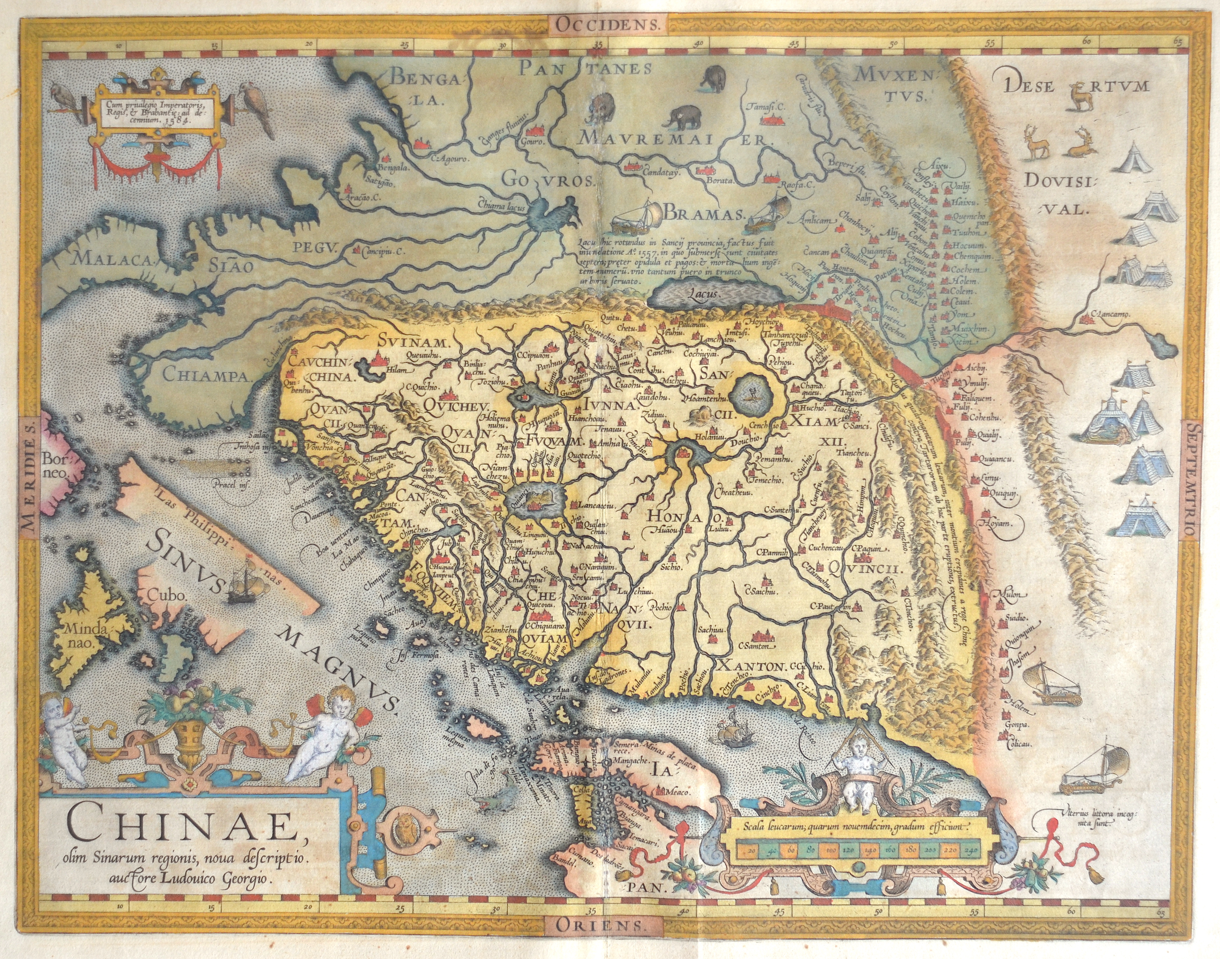
Chinae, olim Sinarum regionis, nova descriptio. Auctore Ludovico Georgio.

| Article ID | ASC1255 |
Title | Chinae, olim Sinarum regionis, nova descriptio. Auctore Ludovico Georgio. |
Description | Rare and first state of Ortelius' map of China, the first western map of China, from the first Spanish Edition of Ortelius' Theatrum Orbis Terrarum , the modern atlas of the World of these days.Ortelius' map of China is taken directly from reports of the Portuguese mapmaker Luis Jorge de Barbuda (Ludovicus Georgius), who made a manuscript map of China which reached Ortelius via Arias Montanus. First published in 1584, Ortelius' map of China is the earliest printed map to focus on China and the first to illustrate the Great Wall of China. Tooley referred to the map as the standard map of the interior of China for over sixty years. With its three lushly designed cartouches and many illustrations of indigenous shelters, modes of transportation and animals, this is one of Ortelius's richest engravings. When this map appeared, it was by far the most accurate representation of China to appear on a printed map. Japan is shown on a curious curved projection reminiscent of Poruguese charts of the period, with Honshu dissected along the line of Lake Biwa. The Great Wall is shown, but only a relatively small section, its length is significantly underestimated. The Tartar ;yurts; are dotted across the plains and steppes of Central and East Asia. |
| Year | ca. 1584 |
Artist | Ortelius (1527-1598) |
Abraham Ortelius (1527–1598) was a Flemish cartographer and publisher from Antwerp. Originally a map colorist, he became a major figure in cartography through his Theatrum Orbis Terrarum (1570), considered the first modern atlas—a uniform collection of reliable maps in book form. Influenced by Gerardus Mercator, Ortelius published several maps before compiling the Theatrum, which clearly showed America as a separate continent. The work was published in 42 editions and 7 languages by 1612. Unlike many of his peers, Ortelius cited his sources, and his atlas became a milestone in mapmaking and geographic knowledge. | |
Historical Description | During the Qin Dynasty of the first emperor Qin Shihuangdi, much was unified, thus laying the foundations for a common cultural identity, including the Chinese script, consisting of thousands of Chinese characters, which is considered to be the oldest still used writing system in the world. According to the myth, China's history spans 5000 years, in which Chinese culture and science, especially Chinese languages, Chinese names, Chinese philosophy, Chinese cuisine, Chinese folk belief and traditional Chinese medicine have developed. However, the historical influence of Chinese traditions and cultural practices has not been confined to this narrow definition, as it has also spread to other Southeast Asian countries like Thailand, Myanmar, Singapore, Malaysia, Indonesia, Cambodia, Laos, Philippines, etc, through the establishment of overseas Chinese communities. The East Asian cultural sphere shares a Confucian ethical philosophy, Buddhism, Taoism, and it historically has shared a 3,000-year-old ancient Han Chinese writing system. The core regions of the East Asian cultural sphere are generally taken to be Greater China, Japan, Korea, and Vietnam. Chinese music, Chinese literature, Chinese painting, Chinese architecture, Chinese garden art and Chinese martial arts are typical of the style of Chinese art. |
| Place of Publication | Antwerp |
| Dimensions (cm) | 37 x 47 cm |
| Condition | Centerfold mounted |
| Coloring | original colored |
| Technique | Copper print |