

- Alsace
- Aquitaine
- Auvergne
- Bourgogne
- Bourgogne-Franche-Comte
- Brittany
- Centre
- Champagne
- France Islands
- Gascogne
- Gironde
- Hauts-de-France
- Ile de France
- Languedoc
- Lothringen
- Midi-Pyrénées
- Nivernais
- Nord-Pas-de-Calais
- Normandie
- Occitanie
- Pas-de-Calais
- Pays de la Loire
- Picardie
- Poitou-Charentes
- Provence-Alpes-Cote d Azur
- Pyrénées
- Rhone- Alpes
- Saintonge
- Savoyen
- Tourain
- Westcoast
Adina Sommer
Antique and Contemporary Art
Winzerer Str. 154
80797 München
telephone
+49 89 304714
business hours:
by appointment
Email
![]()


Chart of the Roads of Brusc and Bandol.
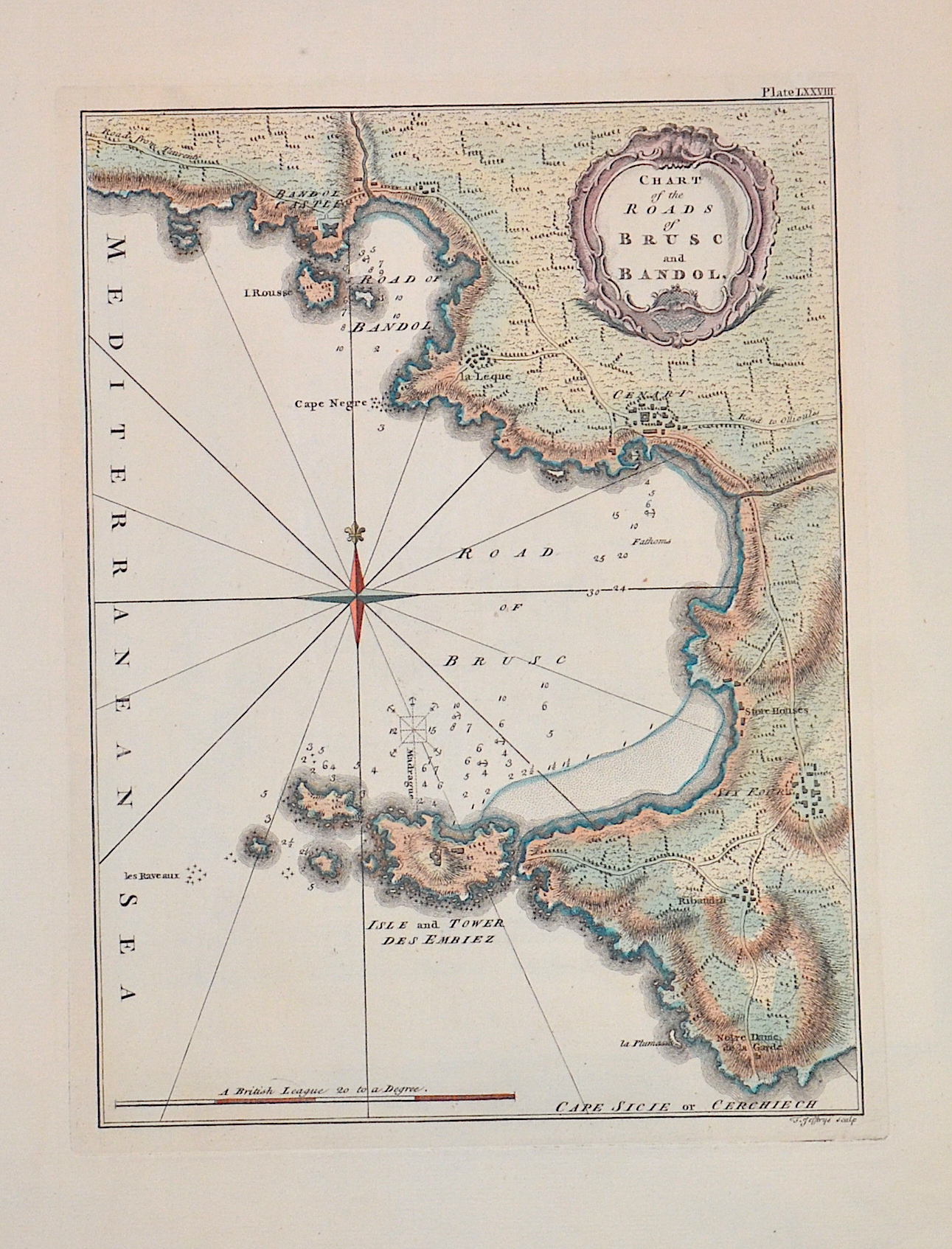

| Article ID | EUF5146 |
Title | Chart of the Roads of Brusc and Bandol. |
Description | Map showing the Mediterranean coast from the town of Bandol (Côte d'Azur) to the Île des Embiez at the port of Le Brusc in the Var department. Furthermore a title cartouche, a compass rose and a mileage indicator. |
| Year | ca. 1760 |
Artist | Jefferys (1719-1771) |
Thomas Jefferys "Geographer to King George III", was an English cartographer who was the leading map supplier of his day. He engraved and printed maps for government and other official bodies and produced a wide range of commercial maps and atlases, especially of North America | |
Historical Description | It is estimated that today's France was settled about 48,000 years ago. Important rock paintings from the Paleolithic period have been preserved in the Lascaux cave From 600 BC Chr. Phoenician and Greek traders founded bases on the Mediterranean coast, while Celts settled from the northwest the country that was later called by the Romans as Gaul. The French Middle Ages were marked by the rise of kingship in the constant struggle against the independence of the nobility and the secular violence of the monasteries and religious orders. Starting from today's Île-de-France, the Capetinians enforced the idea of a unitary state, which was underpinned by participation in various crusades. The Normans invaded Normandy repeatedly, hence its name; in 1066 they conquered England. A long series of armed conflicts with England began under Louis VII after Ludwig's divorced wife Eleonore von Poitou and Aquitaine married Heinrich Plantagenet in 1152 and thus about half of France's territory fell to England. Philip II August, together with the Hohenstaufen family, largely displaced England from France until 1299; the English king Henry III Ludwig IX. recognize as suzerain. From 1226 France became an inheritance monarchy; in 1250 Ludwig IX was one of the most powerful rulers in the West. In the 17th and 18th centuries, France held European leadership and supremacy. The political and cultural charisma was significant: The court of Louis XIV became the model for absolutist states throughout Europe and the French Revolution with the declaration of human and civil rights, together with occupations by Napoleon Bonaparte, started in many countries the time and again Setbacks interrupted development towards democracy. |
| Place of Publication | London |
| Dimensions (cm) | 25,5 x 19 cm |
| Condition | Perfect condition |
| Coloring | original colored |
| Technique | Copper print |